Zastávky na linke
Gänserndorf Bahnhof po ¤,
Gänserndorf Hans-Kudlich-Gasse po 1,20 km ¤,
autobusová zastávka po 1,54 km ¤,
Gänserndorf Augasse po 2,3 km ¤,
Prottes Friedensgasse po 6,3 km ¤,
Prottes Volksschule po 6,7 km ¤,
Prottes Lerchengasse po 7,2 km ¤,
Matzen Hofgartenstraße po 10,6 km ¤,
Matzen Schule po 11,2 km ¤,
Prottes Lerchengasse po 15 km ¤,
Prottes Dörfleser Straße po 16 km ¤,
Ebenthal Florianiplatz po 24 km ¤,
Ebenthal Stillfrieder Straße po 25 km ¤,
Waidendorf Feuerwehr po 29 km ¤,
Dürnkrut Badsiedlung po 31 km ¤,
Dürnkrut Schulen po 32 km ¤,
Dürnkrut Bahnhof po 33 km ¤Zastávky popri linke:, 1 z 2
Gänserndorf Bahnhof po ¤,
Gänserndorf Bahnhof po 5 m ¤,
Gänserndorf Bahnhof po 15 m ¤,
Gänserndorf Villagasse po 100 m ¤,
Trafik po 0,85 km ¤,
Gänserndorf Hans-Kudlich-Gasse po 1,20 km ¤,
autobusová zastávka po 1,52 km ¤,
autobusová zastávka po 1,54 km ¤,
Busbahnhof Gänserndorf po 1,56 km ¤,
autobusová zastávka po 1,56 km ¤,
autobusová zastávka po 1,58 km ¤,
autobusová zastávka po 1,60 km ¤,
autobusová zastávka po 1,64 km ¤,
Gänserndorf Rathausplatz po 1,71 km ¤,
Gänserndorf Rathausplatz po 1,75 km ¤,
Gänserndorf Augasse po 2,2 km ¤,
Gänserndorf Augasse po 2,3 km ¤,
Prottes Friedensgasse po 6,2 km ¤Zastávky popri linke:, 2 z 2
Prottes Friedensgasse po 6,3 km ¤,
Prottes Volksschule po 6,7 km ¤,
Prottes Volksschule po 6,7 km ¤,
Prottes Lerchengasse po 7,2 km ¤,
Matzen Hofgartenstraße po 10,6 km ¤,
Matzen Hofgartenstraße po 10,6 km ¤,
Matzen Schule po 11,2 km ¤,
Prottes Lerchengasse po 15 km ¤,
Prottes Dörfleser Straße po 16 km ¤,
Ebenthal Florianiplatz po 24 km ¤,
Ebenthal Stillfrieder Straße po 25 km ¤,
Waidendorf Feuerwehr po 29 km ¤,
Waidendorf Feuerwehr po 29 km ¤,
Dürnkrut Badsiedlung po 31 km ¤,
Dürnkrut Badsiedlung po 31 km ¤,
Dürnkrut Schulen po 32 km ¤,
Dürnkrut Schulen po 32 km ¤,
Dürnkrut Bahnhof po 33 km ¤Automaty na lístky:
Trafik po 0,85 km ¤prestupné linky:
Bus 551: Groß Enzersdorf Volksschule = > Gänserndorf Busbahnhof po 1,45 km ¤,
Bus 524: Strasshof Werndlgasse = > Gänserndorf Busbahnhof po 1,45 km ¤,
Bus 524: Strasshof Industriestraße = > Gänserndorf Busbahnhof po 1,45 km ¤,
Bus 551: Groß-Enzersdorf Auvorstadt = > Gänserndorf Busbahnhof po 1,45 km ¤,
Bus 551: Gänserndorf = > Groß-Enzersdorf po 1,61 km ¤,
railjet: Praha = > Wien = > Villach po 33 km ¤,
EuroCity Warszawa – Wien po 33 km ¤,
NJ 457: Berlin = > Graz po 33 km ¤,
EN 407: Praha - Wien po 33 km ¤,
REX1: Břeclav = > Wiener Neustadt po 33 km ¤,
railjet: Villach = > Wien = > Praha po 33 km ¤,
EN 40406: Wien - Praha po 33 km ¤,
REX1: Wiener Neustadt = > Břeclav po 33 km ¤,
EuroCity Wien – Warszawa po 33 km ¤,
Bus 525: Gänserndorf Lagerhausstraße = > Gänserndorf Volksschule Má spoločné úseky s linkami:
Bus 528: Gänserndorf Bahnhof = > Weikendorf Volksschule po 20 m ¤ ,
Bus 528: Gänserndorf Bahnhof = > Marchegg Fünfhaus po 20 m ¤ ,
Bus 528: Gänserndorf Bahnhof = > Zwerndorf Ortsmitte po 20 m ¤ ,
Bus 545: Orth an der Donau = > Gänserndorf po 27 m ¤ ,
Bus 546: Stopfenreuth = > Gänserndorf po 27 m ¤ ,
Bus 545: Haringsee = > Gänserndorf po 27 m ¤ ,
Bus 521: Deutsch-Wagram = > Gänserndorf Bahnhof po 199 m ¤ ,
Bus 528: Weikendorf Volksschule = > Gänserndorf Bahnhof po 199 m ¤ ,
Bus 528: Marchegg Fünfhaus = > Gänserndorf Bahnhof po 199 m ¤ ,
Bus 524: Gänserndorf Volksschule = > Gänserndorf Bahnhof po 199 m ¤ ,
Bus 528: Zwerndorf Ortsmitte = > Gänserndorf Bahnhof po 199 m ¤ ,
Bus 105: Gänserndorf Bahnhof = > St. Pölten Hauptbahnhof Nord po 199 m ¤ ,
Bus 521: Deutsch-Wagram = > Gänserndorf Bahnhof po 199 m ¤ ,
Bus 524: Gänserndorf Bahnhof = > Strasshof Werndlgasse = > Gänserndorf Süd Habichtweg po 233 m ¤ ,
Bus 525: Gänserndorf Volksschule = > Gänserndorf Flurgasse po 254 m ¤ ,
Bus 528: Oberweiden Gemeindeamt = > Gänserndorf Busbahnhof po 311 m ¤ ,
Bus 545: Gänserndorf = > Orth an der Donau Biotech Campus = > Orth an der Donau po 311 m ¤ ,
Bus 531: Wolkersdorf Gymnasium = > Auersthal Europa-Siedlung = > Gänserndorf Bahnhof po 311 m ¤ ,
Bus 531: Wolkersdorf Gymnasium = > Gänserndorf Bahnhof po 311 m ¤ ,
Bus 531: Auersthal Schulen = > Schönkirchen Volksschule = > Gänserndorf Bahnhof po 311 m ¤ ,
Bus 531: Auersthal Schulen = > Gänserndorf Bahnhof po 311 m ¤ ,
Bus 524: Gänserndorf Volksschule = > Gänserndorf Süd Eschenweg = > Strasshof Werndlgasse po 311 m ¤ ,
Bus 524: Gänserndorf Volksschule = > Strasshof Werndlgasse po 311 m ¤ ,
Bus 524: Strasshof Kleistgasse = > Gänserndorf Bahnhof po 311 m ¤ ,
Bus 524: Strasshof Werndlgasse = > Gänserndorf Bahnhof po 311 m ¤ ,
Bus 524: Strasshof Grenzstraße 3 = > Gänserndorf Bahnhof po 311 m ¤ ,
Bus 105: St. Pölten Landhaus Nord = > Gänserndorf Bahnhof po 311 m ¤ ,
Bus 546: Gänserndorf = > Markthof = > Stopfenreuth po 311 m ¤ ,
Bus 546: Gänserndorf = > Stopfenreuth po 311 m ¤ ,
Bus 528: Markthof Nr. 10 = > Gänserndorf Busbahnhof po 311 m ¤ ,
Bus 545: Gänserndorf = > Orth an der Donau po 311 m ¤ ,
Bus 545: Gänserndorf = > Haringsee po 311 m ¤ ,
Bus 530: Gänserndorf Bahnhof = > Auersthal Europa-Siedlung = > Wolkersdorf Wiener Straße po 311 m ¤ ,
Bus 530: Gänserndorf Bahnhof = > Wolkersdorf Wiener Straße po 311 m ¤ ,
Bus 530: Wolkersdorf Bahnhof = > Gänserndorf Bahnhof po 311 m ¤ ,
Bus 521: Deutsch-Wagram = > Gänserndorf po 311 m ¤ ,
Bus 521: Gänserndorf = > Deutsch-Wagram po 311 m ¤ ,
Bus 521: Gänserndorf = > Deutsch-Wagram (nicht über Helmahof Andreas-Reischek-Gasse) po 311 m ¤ ,
Bus 525: Gänserndorf Bahnhof = > Gänserndorf Volksschule po 311 m ¤ ,
Bus 536: Gänserndorf Bahnhof = > Spannberg Hauptplatz po 311 m ¤ ,
Bus 535: Gänserndorf Bahnhof = > Mistelbach Bahnhof po 358 m ¤ ,
Bus 535: Gänserndorf Bahnhof = > Mistelbach Bahnhof po 358 m ¤ ,
Bus 537: Gänserndorf Bahnhof = > OMV = > Ebenthal Stillfrieder Straße po 449 m ¤ ,
Bus 535: Mistelbach Bahnhof = > Gänserndorf Bahnhof po 449 m ¤ ,
Bus 534: Gänserndorf Bahnhof = > Zistersdorf Schloßplatz po 449 m ¤ ,
Bus 536: Gänserndorf Bahnhof = > Dürnkrut Bahnhof po 449 m ¤ ,
Bus 537: Gänserndorf Bahnhof = > Matzen Schule po 449 m ¤ ,
Bus 537: Gänserndorf Bahnhof = > Ebenthal Stillfrieder Straße po 449 m ¤ ,
Bus 537: Gänserndorf Bahnhof = > Ebenthal Stillfrieder Straße (ohne Matzen) po 449 m ¤ ,
Bus 528: Gänserndorf Hans-Kudlich-Gasse = > Weikendorf Volksschule (ohne Halt in Gänserndorf Schillergasse, Grillparzergasse) po 1,51 km ¤ ,
Bus 526: Gänserndorf Hans-Kudlich-Gasse = > Angern/March Bahnhof (ohne Dörfles) po 1,51 km ¤ ,
Bus 526: Gänserndorf Hans-Kudlich-Gasse = > Ebenthal Stillfrieder Straße po 1,51 km ¤ ,
Bus 524: Gänserndorf Hans-Kudlich-Gasse = > Strasshof Werndlgasse po 1,51 km ¤ ,
Bus 528: Gänserndorf Hans-Kudlich-Gasse = > Markthof Nr. 10 po 1,51 km ¤ ,
Bus 528: Gänserndorf Hans-Kudlich-Gasse = > Baumgarten/March Ortsmitte (ohne Halt in Gänserndorf Schillergasse, Grillparzergasse) po 1,51 km ¤ ,
Bus 528: Gänserndorf Hans-Kudlich-Gasse = > Baumgarten/March Ortsmitte po 1,51 km ¤ ,
Bus 531: Gänserndorf Busbahnhof = > Auersthal Schulen po 1,72 km ¤ ,
Bus 531: Gänserndorf Bahnhof = > Auersthal Schulen po 1,73 km ¤ ,
Bus 531: Gänserndorf Bahnhof = > Wolkersdorf Mittelschule po 1,73 km ¤ ,
Bus 531: Gänserndorf Bahnhof = > Wolkersdorf Bahnhof po 1,73 km ¤ ,
Bus 525: Gänserndorf Volksschule = > Gänserndorf Rathausplatz po 1,84 km ¤ ,
Bus 526: Angern an der March Bahnhof = > Gänserndorf Bbf (ohne Dörfles) po 1,89 km ¤ ,
Bus 534: Hohenruppersdorf Gemeindeamt = > Gänserndorf Siebenbrunner Straße po 1,89 km ¤ ,
Bus 534: Zistersdorf Schloßplatz = > Gänserndorf Bahnhof po 1,89 km ¤ ,
Bus 526: Ollersdorf Tallesbrunner Straße = > Gänserndorf Bbf po 1,89 km ¤ ,
Bus 526: Angern an der March Marktplatz = > Gänserndorf Bbf po 1,89 km ¤ ,
Bus 536: Spannberg Hauptplatz = > Gänserndorf Busbahnhof po 11,0 km ¤ ,
Bus 532: Matzen Schule = > Auersthal Schulen = > Strasshof Lehargasse po 11,1 km ¤ ,
Bus 534: Matzen Schule = > Hohenruppersdorf Marktplatz po 11,1 km ¤ ,
Bus 534: Matzen Schule = > Obersulz Ortsmitte po 11,1 km ¤ ,
Bus 534: Matzen Schule = > Zistersdorf Schloßplatz po 11,1 km ¤ ,
Bus 534: Raggendorf Hauptstraße = > Matzen Schule po 11,2 km ¤ ,
Bus 532: Strasshof Lehárgasse = > Matzen Schule po 11,2 km ¤ ,
Bus 536: Reyersdorf Kirche = > Spannberg Hauptplatz po 11,2 km ¤ ,
Bus 536: Spannberg Hauptplatz = > Reyersdorf Hauptstraße po 11,2 km ¤ ,
Bus 530: Raggendorf Busbahnhof = > Gänserndorf Bahnhof po 11,3 km ¤ ,
Bus 532: Matzen Schule = > Strasshof Lehargasse po 11,3 km ¤ ,
Bus 530: Gänserndorf Bahnhof = > Auersthal Europa-Siedlung = > Wolkersdorf Wiener Straße po 11,3 km ¤ ,
Bus 530: Gänserndorf Bahnhof = > Wolkersdorf Wiener Straße po 11,3 km ¤ ,
Bus 530: Wolkersdorf Wiener Straße = > Gänserndorf Bahnhof po 11,3 km ¤ ,
Bus 537: Matzen Schule = > Dürnkrut Bahnhof po 16 km ¤ ,
Bus 537: Prottes Volksschule = > Ebenthal Stillfrieder Straße (ohne Matzen) po 24 km ¤ ,
Bus 537: Ebenthal Stillfrieder Straße = > Gänserndorf Bahnhof po 24 km ¤ ,
Bus 537: Matzen Schule = > Ebenthal Stillfrieder Straße po 24 km ¤ ,
Bus 537: Ebenthal Stillfrieder Straße = > OMV = > Gänserndorf Bahnhof po 24 km ¤ ,
Bus 537: Ebenthal Stillfrieder Straße = > Prottes Volksschule po 24 km ¤ ,
Bus 537: Dürnkrut Bahnhof = > Prottes Volksschule po 25 km ¤ ,
Bus 537: Ebenthal Florianiplatz = > Dürnkrut Bahnhof po 25 km ¤ ,
Bus 565: Mistelbach Bahnhof = > Ebenthal = > Dürnkrut Bahnhof po 25 km ¤ ,
Bus 537: Dürnkrut Bahnhof = > Gänserndorf Bahnhof po 29 km ¤ ,
Bus 537: Dürnkrut Bahnhof = > Matzen Schule = > Gänserndorf Bahnhof po 29 km ¤ ,
Bus 537: Dürnkrut Bahnhof = > Ebenthal Florianiplatz po 29 km ¤ ,
Bus 573: Hollabrunn Internat = > Altlichtenwarth Neusiedler Straße po 31 km ¤ ,
Bus 573: Altlichtenwarth Neusiedler Straße = > Hollabrunn Internat po 31 km ¤ ,
Bus 564: Mistelbach Bahnhof = > Dürnkrut Bahnhof po 32 km ¤ ,
Bus 564: Mistelbach Hauptplatz = > Mistelbach Alleegasse = > Drösing Bahnhof po 32 km ¤ ,
Bus 565: Dürnkrut Bahnhof = > Niedersulz Kirche po 32 km ¤ ,
Bus 565: Dürnkrut Bahnhof = > Niedersulz Museumsdorf = > Mistelbach Bahnhof po 32 km ¤ ,
Bus 565: Dürnkrut Bahnhof = > Mistelbach Bahnhof po 32 km ¤ ,
Bus 564: Zistersdorf Schloßplatz = > Drösing Bahnhof (ohne Drösing Kaiser-Josef-Platz) po 32 km ¤ ,
Bus 565: Dürnkrut Bahnhof = > Spannberg Hauptplatz po 32 km ¤ ,
Bus 565: Mistelbach Bahnhof = > Niedersulz Museumsdorf = > Dürnkrut Bahnhof po 32 km ¤ ,
Bus 565: Mistelbach Bahnhof = > Dürnkrut Bahnhof po 32 km ¤ ,
Bus 565: Niedersulz Kirche = > Dürnkrut Bahnhof po 32 km ¤ ,
Bus 564: Drösing Bahnhof = > Lanzendorf Zayabrücke = > Mistelbach Bahnhof po 32 km ¤ ,
Bus 564: Drösing Bahnhof = > Drösing Kaiser-Josef-Platz = > Mistelbach Bahnhof po 32 km ¤ ,
Bus 564: Drösing Bahnhof = > Drösing Kaiser-Josef-Platz = > Wilfersdorf bei Mistelbach Wirtschaftspark = > Mistelbach Bahnhof po 32 km ¤ ,
Bus 536: Matzen Schule = > Dürnkrut Bahnhof po 32 km ¤ ,
Bus 564: Drösing Bahnhof = > Mistelbach Bahnhof po 32 km ¤ ,
Bus 564: Drösing Bahnhof = > Zistersdorf Kaiserstraße (ohne Großinzersdorf) po 32 km ¤ ,
Bus 564: Dürnkrut Bahnhof = > Wilfersdorf Wirtschaftspark = > Mistelbach Bahnhof po 32 km ¤ ,
Bus 536: Dürnkrut Bahnhof = > Gänserndorf Busbahnhof po 32 km ¤ ,
Bus 564: Dürnkrut Bahnhof = > Wilfersdorf bei Mistelbach Wirtschaftspark = > Mistelbach Hauptplatz = > Mistelbach Bahnhof po 32 km ¤ ,
Bus 564: Mistelbach Bahnhof = > Drösing Bahnhof (ohne Großinzersdorf) po 32 km ¤ ,
Bus 564: Mistelbach Bahnhof = > Drösing Bahnhof (ohne Mistelbach Hauptplatz, Drösing Kaiser-Josef-Platz) po 32 km ¤ ,
Bus 564: Mistelbach Bahnhof = > Mistelbach Wirtschaftspark = > Drösing Bahnhof po 32 km ¤ ,
Bus 564: Mistelbach Bahnhof = > Drösing Bahnhof po 32 km ¤ ,
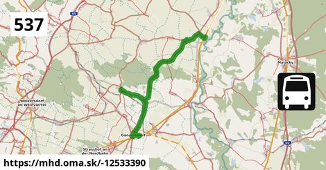
Bus 564: Mistelbach Bahnhof = > Dürnkrut Bahnhof (ohne Mistelbach Hauptplatz) po 32 km ¤ Trasa vedie cez obce
Ebenthal: 7,4 km (22.6 %),
Gemeinde Prottes: 7,4 km (22.6 %),
Gemeinde Gänserndorf: 5,9 km (18.1 %),
Gemeinde Dürnkrut: 5,0 km (15.4 %),
Gemeinde Matzen-Raggendorf: 2,5 km (7.6 %),
Wikipédia
Kruta po 32 km ¤Podobné linky 537:
ine: Bus 537: Ebenthal Florianiplatz = > Dürnkrut Bahnhof, ,
ine: Bus 537: Dürnkrut Bahnhof = > Ebenthal Florianiplatz, ,
ine: Bus 537: Dürnkrut Bahnhof = > Matzen Schule = > Gänserndorf Bahnhof, ,
ine: Bus 537: Gänserndorf Bahnhof = > Ebenthal Stillfrieder Straße, ,
ine: Bus 537: Ebenthal Stillfrieder Straße = > Gänserndorf Bahnhof, ,
ine: Bus 537: Ebenthal Stillfrieder Straße = > Prottes Volksschule, ,
ine: Bus 537: Gänserndorf Bahnhof = > Matzen Schule, ,
ine: Bus 537: Gänserndorf Bahnhof = > OMV = > Ebenthal Stillfrieder Straße, ,
ine: Bus 537: Dürnkrut Bahnhof = > Prottes Volksschule, ,
ine: Bus 537: Matzen Schule = > Ebenthal Stillfrieder Straße, ,
ine: Bus 537: Gänserndorf Bahnhof = > Ebenthal Stillfrieder Straße (ohne Matzen), ,
ine: Bus 537: Prottes Volksschule = > Ebenthal Stillfrieder Straße (ohne Matzen), ,
ine: Bus 537: Ebenthal Stillfrieder Straße = > OMV = > Gänserndorf Bahnhof, ,
ine: Bus 537: Dürnkrut Bahnhof = > Gänserndorf Bahnhof, ,
ine: Bus 537: Matzen Schule = > Dürnkrut Bahnhof,
Viac info:
aktualizovať mapu,
uprav v JOSM (pokročilé),
-12533390,
stiahni GPX, route: bus, to: Dürnkrut Bahnhof, from: Gänserndorf Bahnhof, network: VOR, route name: Bus 537: Gänserndorf Bahnhof => Dürnkrut Bahnhof, osm version: 21, osm changeset: 0, osm timestamp: 2026 03 26T17:41:46Z, Q2516485, de:Verkehrsverbund Ost Region, 2, dlzka: 32826, pocet seg: 1, lon: 16.7577, lat: 48.4072, povodna farba: dr. richard,
Zdroj dát
Mapové údaje pochádzajú z
www.OpenStreetMap.org, databáza je prístupná pod licenciou
ODbL.

Mapový podklad vytvára a aktualizuje
Freemap Slovakia (www.freemap.sk), šíriteľný pod licenciou CC-BY-SA. Fotky sme čerpali z galérie portálu freemap.sk, autori fotiek sú uvedení pri jednotlivých fotkách a sú šíriteľné pod licenciou CC a z wikipédie. Výškový profil trás čerpáme z
SRTM. Niečo vám chýba?
Pridajte to. Sme radi, že tvoríte slobodnú wiki mapu sveta.