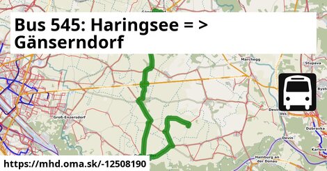
Zastávky na linke
Haringsee Pframastraße po 1 m ¤,
Haringsee Volksschule po 435 m ¤,
Haringsee Hauptstraße/Steingasse po 0,94 km ¤,
Haringsee Friedhofweg po 1,21 km ¤,
Fuchsenbigl Kapelle po 4,2 km ¤,
Straudorf Kirche po 6,3 km ¤,
Wagram/Donau Ortsmitte po 8,9 km ¤,
Orth/Donau Hauptstraße 45 po 13,2 km ¤,
Orth an der Donau Gemeindeamt po 13,9 km ¤,
Orth an der Donau Schlossplatz po 14,2 km ¤,
Orth/Donau Wiener Straße 16/29 po 14,9 km ¤,
Breitstetten Kirche po 20 km ¤,
Breitstetten Leopoldsdorfer Straße po 21 km ¤,
Leopoldsdorf im Marchfeld Breitstetter Straße po 24 km ¤,
Leopoldsdorf im Marchfeld Rathausplatz po 24 km ¤,
Leopoldsdorf/Marchfeld Getreidegasse po 25 km ¤,
Leopoldsdorf/Marchfeld Zuckerfabrik po 26 km ¤,
Siebenbrunn-Leopoldsdorf Bahnhof po 28 km ¤,
Obersiebenbrunn Prinz-Eugen-Straße po 30 km ¤,
Obersiebenbrunn Marktplatz po 31 km ¤,
Obersiebenbrunn Graf-Kollonitsch-Straße po 32 km ¤,
Gänserndorf Siebenbrunner Straße po 38 km ¤,
Gänserndorf Bahnhof po 40 km ¤,
autobusová zastávka po 41 km ¤Zastávky popri linke:, 1 z 2
Haringsee Pframastraße po ¤,
Haringsee Pframastraße po 1 m ¤,
Haringsee Volksschule po 435 m ¤,
Haringsee Volksschule po 437 m ¤,
Haringsee Hauptstraße/Steingasse po 0,94 km ¤,
Haringsee Hauptstraße/Steingasse po 0,94 km ¤,
Haringsee Friedhofweg po 1,21 km ¤,
Haringsee Friedhofweg po 1,21 km ¤,
Fuchsenbigl Kapelle po 4,2 km ¤,
Fuchsenbigl Kapelle po 4,2 km ¤,
Straudorf Kirche po 6,3 km ¤,
Straudorf Kirche po 6,3 km ¤,
Wagram/Donau Ortsmitte po 8,9 km ¤,
Wagram/Donau Ortsmitte po 8,9 km ¤,
Orth/Donau Hauptstraße 75 po 12,8 km ¤,
Orth/Donau Hauptstraße 45 po 13,2 km ¤,
Orth an der Donau Gemeindeamt po 13,9 km ¤,
Orth an der Donau Gemeindeamt po 13,9 km ¤,
Orth an der Donau Schlossplatz po 14,2 km ¤,
Orth an der Donau Schlossplatz po 14,2 km ¤,
Orth/Donau Wiener Straße 16/29 po 14,9 km ¤,
Orth/Donau Wiener Straße 16/29 po 14,9 km ¤,
Breitstetten Am Anger po 20 km ¤,
Breitstetten Kirche po 20 km ¤,
Breitstetten Kirche po 20 km ¤Zastávky popri linke:, 2 z 2
Breitstetten Leopoldsdorfer Straße po 21 km ¤,
Breitstetten Leopoldsdorfer Straße po 21 km ¤,
Leopoldsdorf im Marchfeld Breitstetter Straße po 24 km ¤,
Leopoldsdorf im Marchfeld Breitstetter Straße po 24 km ¤,
Leopoldsdorf im Marchfeld Rathausplatz po 24 km ¤,
Leopoldsdorf im Marchfeld Rathausplatz po 24 km ¤,
Leopoldsdorf/Marchfeld Getreidegasse po 25 km ¤,
Leopoldsdorf/Marchfeld Getreidegasse po 25 km ¤,
Regina Ivanics po 25 km ¤,
Leopoldsdorf/Marchfeld Zuckerfabrik po 26 km ¤,
Leopoldsdorf/Marchfeld Zuckerfabrik po 26 km ¤,
Siebenbrunn-Leopoldsdorf Bahnhof po 28 km ¤,
Obersiebenbrunn Prinz-Eugen-Straße po 30 km ¤,
Obersiebenbrunn Prinz-Eugen-Straße po 30 km ¤,
Obersiebenbrunn Marktplatz po 31 km ¤,
Obersiebenbrunn Marktplatz po 31 km ¤,
Obersiebenbrunn Graf-Kollonitsch-Straße po 31 km ¤,
Obersiebenbrunn Graf-Kollonitsch-Straße po 32 km ¤,
Gänserndorf Siebenbrunner Straße po 38 km ¤,
Gänserndorf Siebenbrunner Straße po 38 km ¤,
Gänserndorf Villagasse po 40 km ¤,
Gänserndorf Bahnhof po 40 km ¤,
Gänserndorf Bahnhof po 40 km ¤,
Gänserndorf Bahnhof po 40 km ¤,
Trafik po 41 km ¤Má spoločné úseky s linkami:
Bus 541: Straudorf Kirche = > Schönfeld-Lassee po 2,9 km ¤ ,
Bus 545: Haringsee = > Orth an der Donau po 12,4 km ¤ ,
Bus 550: Orth an der Donau Schlossplatz = > Engelhartstetten Volksschule po 12,4 km ¤ ,
Bus 550: Engelhartstetten Kirche = > Wien Aspernstraße po 12,8 km ¤ ,
Bus 550: Engelhartstetten Volksschule = > Großenzersdorf Stadtmauer po 12,8 km ¤ ,
Bus 552: Stopfenreuth Uferstraße = > Wien Aspernstraße po 12,8 km ¤ ,
Bus 552: Stopfenreuth Uferstraße = > Orth an der Donau Biotech Campus = > Groß-Enzersdorf Busbahnhof po 12,8 km ¤ ,
Bus 550: Wien Aspernstraße = > Hainburg an der Donau Landesklinikum po 12,8 km ¤ ,
Bus 550: Hainburg an der Donau Landesklinikum = > Wien Aspernstraße po 12,8 km ¤ ,
Bus 552: Stopfenreuth Uferstraße = > Großenzersdorf Busbahnhof po 12,8 km ¤ ,
Bus 552: Groß-Enzersdorf Busbahnhof = > Stopfenreuth Uferstraße po 12,8 km ¤ ,
Bus 552: Stopfenreuth Uferstraße = > Großenzersdorf Stadtmauer po 12,8 km ¤ ,
Bus 552: Groß-Enzersdorf Stadtmauer = > Stopfenreuth Uferstraße po 12,8 km ¤ ,
Bus 545: Obersiebenbrunn = > Orth an der Donau po 14,3 km ¤ ,
Bus 545: Orth/Donau Wiener Straße = > Haringsee po 14,3 km ¤ ,
Bus 550: Orth an der Donau Gemeindeamt = > Wien Aspernstraße po 14,9 km ¤ ,
Bus 553: Orth an der Donau Gemeindeamt = > Großenzersdorf Busbahnhof po 14,9 km ¤ ,
Bus 553: Orth an der Donau Gemeindeamt = > Mühlleiten Hubertusstraße = > Großenzersdorf Busbahnhof po 14,9 km ¤ ,
Bus 550: Wien Aspernstraße = > Orth an der Donau Biotech Campus = > Orth an der Donau Gemeindeamt po 14,9 km ¤ ,
Bus 553: Orth an der Donau Gemeindeamt = > Mühlleiten Hubertusstraße = > Großenzersdorf Stadtmauer po 14,9 km ¤ ,
Bus 552: Groß-Enzersdorf Busbahnhof = > Orth an der Donau Gemeindeamt po 14,9 km ¤ ,
Bus 552: Orth an der Donau Gemeindeamt = > Großenzersdorf Busbahnhof po 14,9 km ¤ ,
Bus 553: Großenzersdorf Busbahnhof = > Orth an der Donau Gemeindeamt po 14,9 km ¤ ,
Bus 553: Großenzersdorf Busbahnhof = > Mühlleiten Hubertusstraße = > Orth an der Donau Gemeindeamt po 14,9 km ¤ ,
Bus 552: Groß-Enzersdorf Stadtmauer = > Orth an der Donau Gemeindeamt po 14,9 km ¤ ,
Bus 550: Wien Aspernstraße = > Orth an der Donau Gemeindeamt po 14,9 km ¤ ,
Bus 545: Leopoldsdorf im Marchfeld = > Haringsee po 20 km ¤ ,
Bus 554: Großhofen Landesstraße = > Orth/Donau Gemeindeamt po 24 km ¤ ,
Bus 554: Deutsch-Wagram Bahnhof = > Orth an der Donau Schlossplatz po 24 km ¤ ,
Bus 554: Orth an der Donau Gemeindeamt = > Deutsch-Wagram Bahnhof po 24 km ¤ ,
Bus 554: Orth an der Donau Schlossplatz = > Deutsch-Wagram Bahnhof po 24 km ¤ ,
Bus 541: Haringsee Pframastraße = > Siebenbrunn-Leopoldsdorf po 25 km ¤ ,
Bus 541: Siebenbrunn-Leopoldsdorf = > Schönfeld im Marchfeld Hauptstraße po 25 km ¤ ,
Bus 541: Schönfeld-Lassee = > Siebenbrunn-Leopoldsdorf po 25 km ¤ ,
Bus 541: Siebenbrunn-Leopoldsdorf = > Schönfeld-Lassee po 25 km ¤ ,
Bus 545: Leopoldsdorf im Marchfeld = > Untersiebenbrunn po 27 km ¤ ,
Bus 540: Schloßhof = > Wien Aspern Nord po 31 km ¤ ,
Bus 540: Obersiebenbrunn Marktplatz = > Wien Aspern Nord po 31 km ¤ ,
Bus 540: Wien Hausfeldstraße = > Schloßhof po 31 km ¤ ,
Bus 540: Schloßhof = > Obersiebenbrunn Marktplatz po 31 km ¤ ,
Bus 546: Obersiebenbrunn Marktplatz = > Stopfenreuth po 31 km ¤ ,
Bus 545: Gänserndorf = > Orth an der Donau po 37 km ¤ ,
Bus 545: Gänserndorf = > Orth an der Donau Biotech Campus = > Orth an der Donau po 37 km ¤ ,
Bus 524: Gänserndorf Hans-Kudlich-Gasse = > Strasshof Werndlgasse po 38 km ¤ ,
Bus 525: Gänserndorf Bockfließer Weg = > Gänserndorf Volksschule po 38 km ¤ ,
Bus 525: Gänserndorf Lagerhausstraße = > Gänserndorf Volksschule po 38 km ¤ ,
Bus 524: Strasshof Industriestraße = > Gänserndorf Busbahnhof po 38 km ¤ ,
Bus 534: Hohenruppersdorf Gemeindeamt = > Gänserndorf Siebenbrunner Straße po 38 km ¤ ,
Bus 525: Gänserndorf Volksschule = > Gänserndorf Rathausplatz po 39 km ¤ ,
Bus 531: Gänserndorf Bahnhof = > Wolkersdorf Mittelschule po 39 km ¤ ,
Bus 531: Gänserndorf Bahnhof = > Wolkersdorf Bahnhof po 39 km ¤ ,
Bus 531: Gänserndorf Bahnhof = > Auersthal Schulen po 39 km ¤ ,
Bus 521: Deutsch-Wagram = > Gänserndorf po 39 km ¤ ,
Bus 546: Stopfenreuth = > Gänserndorf po 39 km ¤ ,
Bus 537: Ebenthal Stillfrieder Straße = > OMV = > Gänserndorf Bahnhof po 39 km ¤ ,
Bus 537: Dürnkrut Bahnhof = > Gänserndorf Bahnhof po 39 km ¤ ,
Bus 528: Gänserndorf Hans-Kudlich-Gasse = > Baumgarten/March Ortsmitte po 39 km ¤ ,
Bus 528: Gänserndorf Hans-Kudlich-Gasse = > Baumgarten/March Ortsmitte (ohne Halt in Gänserndorf Schillergasse, Grillparzergasse) po 39 km ¤ ,
Bus 537: Dürnkrut Bahnhof = > Matzen Schule = > Gänserndorf Bahnhof po 39 km ¤ ,
Bus 526: Ollersdorf Tallesbrunner Straße = > Gänserndorf Bbf po 39 km ¤ ,
Bus 526: Angern an der March Marktplatz = > Gänserndorf Bbf po 39 km ¤ ,
Bus 526: Angern an der March Bahnhof = > Gänserndorf Bbf (ohne Dörfles) po 39 km ¤ ,
Bus 526: Gänserndorf Hans-Kudlich-Gasse = > Ebenthal Stillfrieder Straße po 39 km ¤ ,
Bus 526: Gänserndorf Hans-Kudlich-Gasse = > Angern/March Bahnhof (ohne Dörfles) po 39 km ¤ ,
Bus 521: Deutsch-Wagram = > Gänserndorf Bahnhof po 39 km ¤ ,
Bus 521: Deutsch-Wagram = > Gänserndorf Bahnhof po 39 km ¤ ,
Bus 537: Ebenthal Stillfrieder Straße = > Gänserndorf Bahnhof po 39 km ¤ ,
Bus 528: Gänserndorf Hans-Kudlich-Gasse = > Markthof Nr. 10 po 39 km ¤ ,
Bus 528: Gänserndorf Hans-Kudlich-Gasse = > Weikendorf Volksschule (ohne Halt in Gänserndorf Schillergasse, Grillparzergasse) po 39 km ¤ ,
Bus 528: Marchegg Fünfhaus = > Gänserndorf Bahnhof po 39 km ¤ ,
Bus 528: Weikendorf Volksschule = > Gänserndorf Bahnhof po 39 km ¤ ,
Bus 528: Zwerndorf Ortsmitte = > Gänserndorf Bahnhof po 39 km ¤ ,
Bus 534: Gänserndorf Bahnhof = > Zistersdorf Schloßplatz po 40 km ¤ ,
Bus 524: Strasshof Grenzstraße 3 = > Gänserndorf Bahnhof po 40 km ¤ ,
Bus 536: Gänserndorf Bahnhof = > Spannberg Hauptplatz po 40 km ¤ ,
Bus 536: Gänserndorf Bahnhof = > Dürnkrut Bahnhof po 40 km ¤ ,
Bus 524: Strasshof Werndlgasse = > Gänserndorf Bahnhof po 40 km ¤ ,
Bus 528: Gänserndorf Bahnhof = > Weikendorf Volksschule po 40 km ¤ ,
Bus 528: Gänserndorf Bahnhof = > Marchegg Fünfhaus po 40 km ¤ ,
Bus 528: Gänserndorf Bahnhof = > Zwerndorf Ortsmitte po 40 km ¤ ,
Bus 537: Gänserndorf Bahnhof = > Ebenthal Stillfrieder Straße (ohne Matzen) po 40 km ¤ ,
Bus 537: Gänserndorf Bahnhof = > Dürnkrut Bahnhof po 40 km ¤ ,
Bus 537: Gänserndorf Bahnhof = > Ebenthal Stillfrieder Straße po 40 km ¤ ,
Bus 537: Gänserndorf Bahnhof = > OMV = > Ebenthal Stillfrieder Straße po 40 km ¤ ,
Bus 537: Gänserndorf Bahnhof = > Matzen Schule po 40 km ¤ ,
Bus 524: Gänserndorf Volksschule = > Strasshof Werndlgasse po 40 km ¤ ,
Bus 524: Gänserndorf Volksschule = > Gänserndorf Süd Eschenweg = > Strasshof Werndlgasse po 40 km ¤ ,
Bus 536: Spannberg Hauptplatz = > Gänserndorf Busbahnhof po 40 km ¤ ,
Bus 536: Dürnkrut Bahnhof = > Gänserndorf Busbahnhof po 40 km ¤ ,
Bus 524: Gänserndorf Volksschule = > Gänserndorf Bahnhof po 40 km ¤ ,
Bus 534: Zistersdorf Schloßplatz = > Gänserndorf Bahnhof po 40 km ¤ ,
Bus 530: Gänserndorf Bahnhof = > Wolkersdorf Wiener Straße po 40 km ¤ ,
Bus 530: Gänserndorf Bahnhof = > Auersthal Europa-Siedlung = > Wolkersdorf Wiener Straße po 40 km ¤ ,
Bus 546: Gänserndorf = > Markthof = > Stopfenreuth po 40 km ¤ ,
Bus 528: Markthof Nr. 10 = > Gänserndorf Busbahnhof po 40 km ¤ ,
Bus 525: Gänserndorf Volksschule = > Gänserndorf Flurgasse po 40 km ¤ ,
Bus 530: Wolkersdorf Bahnhof = > Gänserndorf Bahnhof po 40 km ¤ ,
Bus 528: Oberweiden Gemeindeamt = > Gänserndorf Busbahnhof po 40 km ¤ ,
Bus 531: Auersthal Schulen = > Gänserndorf Bahnhof po 40 km ¤ ,
Bus 531: Auersthal Schulen = > Schönkirchen Volksschule = > Gänserndorf Bahnhof po 40 km ¤ ,
Bus 531: Wolkersdorf Gymnasium = > Gänserndorf Bahnhof po 40 km ¤ ,
Bus 105: St. Pölten Landhaus Nord = > Gänserndorf Bahnhof po 40 km ¤ ,
Bus 531: Wolkersdorf Gymnasium = > Auersthal Europa-Siedlung = > Gänserndorf Bahnhof po 40 km ¤ ,
Bus 546: Gänserndorf = > Stopfenreuth po 40 km ¤ ,
Bus 521: Gänserndorf = > Deutsch-Wagram po 40 km ¤ ,
Bus 521: Gänserndorf = > Deutsch-Wagram (nicht über Helmahof Andreas-Reischek-Gasse) po 40 km ¤ ,
Bus 524: Gänserndorf Bahnhof = > Strasshof Werndlgasse = > Gänserndorf Süd Habichtweg po 40 km ¤ ,
Bus 525: Gänserndorf Bahnhof = > Gänserndorf Volksschule po 40 km ¤ ,
Bus 105: Gänserndorf Bahnhof = > St. Pölten Hauptbahnhof Nord po 40 km ¤ ,
Bus 535: Mistelbach Bahnhof = > Gänserndorf Bahnhof po 40 km ¤ ,
Bus 535: Gänserndorf Bahnhof = > Mistelbach Bahnhof po 41 km ¤ ,
Bus 535: Gänserndorf Bahnhof = > Mistelbach Bahnhof po 41 km ¤ ,
Bus 524: Strasshof Kleistgasse = > Gänserndorf Bahnhof po 41 km ¤ ,
Bus 545: Orth an der Donau = > Gänserndorf po 41 km ¤ ,
Bus 545: Gänserndorf = > Haringsee po 41 km ¤ ,
Bus 524: Strasshof Werndlgasse = > Gänserndorf Busbahnhof po 41 km ¤ Trasa vedie cez obce
Gemeinde Orth an der Donau: 8,2 km (19.7 %),
Gemeinde Obersiebenbrunn: 8,0 km (19.4 %),
Gemeinde Leopoldsdorf im Marchfelde: 8,0 km (19.2 %),
Haringsee: 7,4 km (17.8 %),
Gemeinde Gänserndorf: 6,1 km (14.7 %),
Eckartsau: 2,5 km (6.2 %),
Podobné linky 545:
ine: Bus 545: Obersiebenbrunn = > Orth an der Donau, ,
ine: Bus 545: Leopoldsdorf im Marchfeld = > Untersiebenbrunn, ,
ine: Bus 545: Gänserndorf = > Haringsee, ,
ine: Bus 545, ,
ine: Bus 545: Gänserndorf = > Orth an der Donau Biotech Campus = > Orth an der Donau, ,
ine: Bus 545: Leopoldsdorf im Marchfeld = > Haringsee, ,
ine: Bus 545: Haringsee = > Orth an der Donau, ,
ine: Bus 545: Orth/Donau Wiener Straße = > Haringsee, ,
ine: Bus 545: Gänserndorf = > Orth an der Donau, ,
ine: Bus 545: Pezinok = > Šenkvice = > Budmerice, ,
ine: Bus 545: Orth an der Donau = > Gänserndorf, ,
ine: Bus 545: Budmerice = > Šenkvice = > Pezinok,
Viac info:
aktualizovať mapu,
uprav v JOSM (pokročilé),
-12508190,
stiahni GPX, route: bus, to: Gänserndorf Busbahnhof, from: Haringsee Pframastraße, network: VOR, route name: Bus 545: Haringsee => Gänserndorf, osm version: 42, osm changeset: 0, osm timestamp: 2026 05 06T15:41:55Z, Q2516485, 2, dlzka: 41418, pocet seg: 1, lon: 16.7200, lat: 48.2229, povodna farba: dr. richard no blaguss,
Zdroj dát
Mapové údaje pochádzajú z
www.OpenStreetMap.org, databáza je prístupná pod licenciou
ODbL.

Mapový podklad vytvára a aktualizuje
Freemap Slovakia (www.freemap.sk), šíriteľný pod licenciou CC-BY-SA. Fotky sme čerpali z galérie portálu freemap.sk, autori fotiek sú uvedení pri jednotlivých fotkách a sú šíriteľné pod licenciou CC a z wikipédie. Výškový profil trás čerpáme z
SRTM. Niečo vám chýba?
Pridajte to. Sme radi, že tvoríte slobodnú wiki mapu sveta.