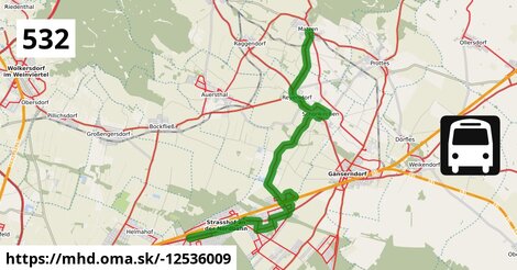
Zastávky na linke
Strasshof Lehárgasse po 1 m ¤,
Strasshof Rote Burg po 1,18 km ¤,
Strasshof Billrothgasse po 1,69 km ¤,
Strasshof Petzoldgasse po 2,3 km ¤,
Strasshof Anzengrubergasse po 2,8 km ¤,
Strasshof Kleistgasse po 3,9 km ¤,
Strasshof Schubertgasse po 5,3 km ¤,
Schönkirchen Tannengasse po 6,6 km ¤,
Silberwald Bahnhof po 7,3 km ¤,
Schönkirchen Waldgasse po 8,2 km ¤,
Schönkirchen Mozartgasse po 8,4 km ¤,
Schönkirchen Haselnussgasse po 9,0 km ¤,
Schönkirchen Volksschule po 14,2 km ¤,
Schönkirchen Schloss po 16 km ¤,
Reyersdorf Hauptstraße po 17 km ¤,
Reyersdorf Kirche po 17 km ¤,
Matzen Schule po 20 km ¤Zastávky popri linke:, 1 z 2
Strasshof Lehárgasse po 1 m ¤,
Strasshof Rote Burg po 1,15 km ¤,
Strasshof Rote Burg po 1,18 km ¤,
Strasshof Billrothgasse po 1,57 km ¤,
Strasshof Billrothgasse po 1,69 km ¤,
Strasshof Petzoldgasse po 2,3 km ¤,
Strasshof Petzoldgasse po 2,3 km ¤,
Strasshof Anzengrubergasse po 2,8 km ¤,
Strasshof Anzengrubergasse po 2,8 km ¤,
Strasshof Kleistgasse po 3,9 km ¤,
Strasshof Kleistgasse po 3,9 km ¤,
Strasshof Marterlweg po 4,4 km ¤,
Strasshof Marterlweg po 4,5 km ¤,
Strasshof Josef-Schwarz-Straße po 4,9 km ¤,
Strasshof Josef-Schwarz-Straße po 5,0 km ¤,
Strasshof Schubertgasse po 5,3 km ¤Zastávky popri linke:, 2 z 2
Ideenbäckerei Geier po 5,4 km ¤,
Schönkirchen Tannengasse po 6,6 km ¤,
Silberwald Bahnhof po 7,3 km ¤,
Schönkirchen Waldgasse po 8,2 km ¤,
Schönkirchen Mozartgasse po 8,4 km ¤,
Schönkirchen Haselnussgasse po 9,0 km ¤,
Silberwald Bahnhof po 9,2 km ¤,
Schönkirchen Volksschule po 14,2 km ¤,
Schönkirchen Schloss po 16 km ¤,
Schönkirchen Schloss po 16 km ¤,
Reyersdorf Hauptstraße po 17 km ¤,
Reyersdorf Hauptstraße po 17 km ¤,
Reyersdorf Kirche po 17 km ¤,
Reyersdorf Kirche po 17 km ¤,
Matzen Schule po 20 km ¤Má spoločné úseky s linkami:
Bus 521: Deutsch-Wagram = > Gänserndorf Bahnhof po 1,28 km ¤ ,
Bus 523: Anton-Fromm-Gasse = > Schulcampus po 1,28 km ¤ ,
Bus 523: Industriestraße = > Schulcampus po 1,28 km ¤ ,
Bus 521: Deutsch-Wagram = > Gänserndorf po 1,28 km ¤ ,
Bus 524: Strasshof Industriestraße = > Gänserndorf Busbahnhof po 1,28 km ¤ ,
Bus 521: Gänserndorf = > Deutsch-Wagram po 1,28 km ¤ ,
Bus 521: Gänserndorf = > Deutsch-Wagram (nicht über Helmahof Andreas-Reischek-Gasse) po 1,28 km ¤ ,
Bus 521: Deutsch-Wagram = > Gänserndorf Bahnhof po 1,28 km ¤ ,
Bus 521: Deutsch-Wagram = > Gänserndorf Süd Volksschule po 1,28 km ¤ ,
Bus 532: Schönkirchen Volksschule = > Reyersdorf Hauptstraße = > Strasshof Lehargasse po 1,32 km ¤ ,
Bus 532: Matzen Schule = > Strasshof Lehargasse po 1,32 km ¤ ,
Bus 523: Schulcampus = > Anzengrubergasse po 1,43 km ¤ ,
Bus 532: Matzen Schule = > Auersthal Schulen = > Strasshof Lehargasse po 1,65 km ¤ ,
Bus 523: Sillerstraße = > Schulcampus po 3,9 km ¤ ,
Bus 524: Strasshof Kleistgasse = > Gänserndorf Bahnhof po 3,9 km ¤ ,
Bus 523: Schulcampus = > Silberwald po 4,2 km ¤ ,
Bus 523: Werndlgasse = > Schulcampus po 4,2 km ¤ ,
Bus 523: Albert-Sever-Straße = > Schulcampus po 7,4 km ¤ ,
Bus 532: Schönkirchen Volksschule = > Reyersdorf Hauptstraße = > Schönkirchen Tannengasse po 7,7 km ¤ ,
Bus 532: Schönkirchen Tannengasse = > Schönkirchen Volksschule po 7,7 km ¤ ,
Bus 532: Schönkirchen Volksschule = > Schönkirchen Tannengasse po 7,7 km ¤ ,
Bus 536: Spannberg Hauptplatz = > Gänserndorf Busbahnhof po 14,0 km ¤ ,
Bus 536: Dürnkrut Bahnhof = > Gänserndorf Busbahnhof po 14,0 km ¤ ,
Bus 535: Gänserndorf Bahnhof = > Mistelbach Bahnhof po 14,0 km ¤ ,
Bus 535: Mistelbach Bahnhof = > Gänserndorf Bahnhof po 14,0 km ¤ ,
Bus 535: Gänserndorf Bahnhof = > Mistelbach Bahnhof po 14,0 km ¤ ,
Bus 531: Auersthal Schulen = > Schönkirchen Volksschule = > Gänserndorf Bahnhof po 16 km ¤ ,
Bus 105: Gänserndorf Bahnhof = > St. Pölten Hauptbahnhof Nord po 17 km ¤ ,
Bus 531: Gänserndorf Bahnhof = > Wolkersdorf Mittelschule po 17 km ¤ ,
Bus 531: Gänserndorf Bahnhof = > Wolkersdorf Bahnhof po 17 km ¤ ,
Bus 531: Gänserndorf Bahnhof = > Auersthal Schulen po 17 km ¤ ,
Bus 531: Gänserndorf Busbahnhof = > Auersthal Schulen po 17 km ¤ ,
Bus 531: Wolkersdorf Gymnasium = > Auersthal Europa-Siedlung = > Gänserndorf Bahnhof po 17 km ¤ ,
Bus 531: Wolkersdorf Mittelschule = > Reyersdorf Hauptstraße po 17 km ¤ ,
Bus 531: Wolkersdorf Gymnasium = > Gänserndorf Bahnhof po 17 km ¤ ,
Bus 531: Wolkersdorf Volksschule = > Reyersdorf Hauptstraße po 17 km ¤ ,
Bus 531: Auersthal Schulen = > Reyersdorf Hauptstraße po 17 km ¤ ,
Bus 531: Auersthal Schulen = > Gänserndorf Bahnhof po 17 km ¤ ,
Bus 105: St. Pölten Landhaus Nord = > Gänserndorf Bahnhof po 17 km ¤ ,
Bus 536: Gänserndorf Bahnhof = > Spannberg Hauptplatz po 17 km ¤ ,
Bus 536: Gänserndorf Bahnhof = > Dürnkrut Bahnhof po 17 km ¤ ,
Bus 536: Spannberg Hauptplatz = > Reyersdorf Hauptstraße po 17 km ¤ ,
Bus 536: Reyersdorf Kirche = > Spannberg Hauptplatz po 17 km ¤ ,
Bus 537: Gänserndorf Bahnhof = > OMV = > Ebenthal Stillfrieder Straße po 20 km ¤ ,
Bus 537: Gänserndorf Bahnhof = > Ebenthal Stillfrieder Straße po 20 km ¤ ,
Bus 537: Gänserndorf Bahnhof = > Matzen Schule po 20 km ¤ ,
Bus 537: Dürnkrut Bahnhof = > Matzen Schule = > Gänserndorf Bahnhof po 20 km ¤ ,
Bus 534: Gänserndorf Bahnhof = > Zistersdorf Schloßplatz po 20 km ¤ ,
Bus 530: Gänserndorf Bahnhof = > Auersthal Europa-Siedlung = > Wolkersdorf Wiener Straße po 20 km ¤ ,
Bus 530: Gänserndorf Bahnhof = > Wolkersdorf Wiener Straße po 20 km ¤ ,
Bus 530: Wolkersdorf Wiener Straße = > Gänserndorf Bahnhof po 20 km ¤ ,
Bus 530: Raggendorf Busbahnhof = > Gänserndorf Bahnhof po 20 km ¤ ,
Bus 534: Hohenruppersdorf Gemeindeamt = > Gänserndorf Siebenbrunner Straße po 20 km ¤ ,
Bus 534: Zistersdorf Schloßplatz = > Gänserndorf Bahnhof po 20 km ¤ ,
Bus 534: Raggendorf Hauptstraße = > Matzen Schule po 20 km ¤ ,
Bus 530: Wolkersdorf Bahnhof = > Gänserndorf Bahnhof po 20 km ¤ ,
Bus 530: Gänserndorf Bahnhof = > Wolkersdorf Wiener Straße po 20 km ¤ ,
Bus 530: Gänserndorf Bahnhof = > Auersthal Europa-Siedlung = > Wolkersdorf Wiener Straße po 20 km ¤ ,
Bus 537: Gänserndorf Bahnhof = > Dürnkrut Bahnhof po 20 km ¤ Podobné linky 532:
ine: Bus 532: Matzen Schule = > Auersthal Schulen = > Strasshof Lehargasse, ,
ine: Bus 532: Schönkirchen Volksschule = > Schönkirchen Tannengasse, ,
ine: Bus 532: Schönkirchen Volksschule = > Reyersdorf Hauptstraße = > Strasshof Lehargasse, ,
ine: Bus 532: Matzen Schule = > Strasshof Lehargasse, ,
ine: Bus 532: Schönkirchen Volksschule = > Reyersdorf Hauptstraße = > Schönkirchen Tannengasse, ,
ine: Bus 532: Schönkirchen Tannengasse = > Schönkirchen Volksschule,
Viac info:
aktualizovať mapu,
uprav v JOSM (pokročilé),
-12536009,
stiahni GPX, route: bus, to: Matzen Schule, from: Strasshof Lehárgasse, network: VOR, route name: Bus 532: Strasshof Lehárgasse => Matzen Schule, osm version: 14, osm changeset: 0, osm timestamp: 2025 12 28T00:54:46Z, Q2516485, de:Verkehrsverbund Ost Region, 2, dlzka: 20088, pocet seg: 1, lon: 16.6761, lat: 48.3444, povodna farba: dr. richard no,
Zdroj dát
Mapové údaje pochádzajú z
www.OpenStreetMap.org, databáza je prístupná pod licenciou
ODbL.

Mapový podklad vytvára a aktualizuje
Freemap Slovakia (www.freemap.sk), šíriteľný pod licenciou CC-BY-SA. Fotky sme čerpali z galérie portálu freemap.sk, autori fotiek sú uvedení pri jednotlivých fotkách a sú šíriteľné pod licenciou CC a z wikipédie. Výškový profil trás čerpáme z
SRTM. Niečo vám chýba?
Pridajte to. Sme radi, že tvoríte slobodnú wiki mapu sveta.