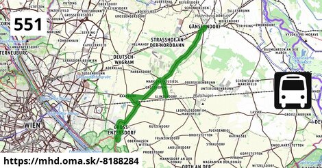
Zastávky na linke
Groß-Enzersdorf Auvorstadt po 4 m ¤,
Groß-Enzersdorf Napoleongasse po 375 m ¤,
Groß-Enzersdorf Fliedergasse po 0,90 km ¤,
Groß Enzersdorf Volksschule po 1,56 km ¤,
Groß-Enzersdorf Busbahnhof po 2,2 km ¤,
Großenzersdorf Stadtmauer po 2,8 km ¤,
Raasdorf Bahnhof po 9,0 km ¤,
Raasdorf Kirche po 10,9 km ¤,
Großhofen Landesstraße po 16 km ¤,
Markgrafneusiedl Gemeindeamt po 18 km ¤,
Markgrafneusiedl Altes Dorf 29/68 po 18 km ¤,
Glinzendorf Kirche po 20 km ¤,
Markgrafneusiedl Feuerwehr po 22 km ¤,
Gänserndorf Süd Volksschule po 28 km ¤,
Gänserndorf Süd Silberwaldstraße po 29 km ¤,
autobusová zastávka po 33 km ¤Zastávky popri linke:, 1 z 2
Groß-Enzersdorf Auvorstadt po 4 m ¤,
Groß-Enzersdorf Napoleongasse po 375 m ¤,
Groß-Enzersdorf Fliedergasse po 0,90 km ¤,
Groß-Enzersdorf Fliedergasse po 0,91 km ¤,
Trafik Krekner po 1,04 km ¤,
Groß Enzersdorf Volksschule po 1,56 km ¤,
Groß-Enzersdorf Busbahnhof po 2,1 km ¤,
Groß-Enzersdorf Busbahnhof po 2,1 km ¤,
Groß-Enzersdorf Busbahnhof po 2,2 km ¤,
Groß-Enzersdorf po 2,2 km ¤,
Groß-Enzersdorf Busbahnhof po 2,2 km ¤,
Großenzersdorf Stadtmauer po 2,8 km ¤,
Großenzersdorf Stadtmauer po 2,8 km ¤,
Raasdorf Bahnhof po 9,0 km ¤,
Trafik Raasdorf po 10,9 km ¤,
Raasdorf Kirche po 10,9 km ¤,
Raasdorf Kirche po 10,9 km ¤Zastávky popri linke:, 2 z 2
Großhofen Landesstraße po 16 km ¤,
Großhofen Landesstraße po 16 km ¤,
Markgrafneusiedl Gemeindeamt po 18 km ¤,
Markgrafneusiedl Gemeindeamt po 18 km ¤,
Markgrafneusiedl Altes Dorf 29/68 po 18 km ¤,
Markgrafneusiedl Altes Dorf 29/68 po 18 km ¤,
Glinzendorf Kirche po 20 km ¤,
Markgrafneusiedl Feuerwehr po 22 km ¤,
Gänserndorf Süd Volksschule po 28 km ¤,
Gänserndorf Süd Volksschule po 28 km ¤,
Gänserndorf Süd Silberwaldstraße po 29 km ¤,
Gänserndorf Süd Silberwaldstraße po 29 km ¤,
autobusová zastávka po 33 km ¤,
autobusová zastávka po 33 km ¤,
Busbahnhof Gänserndorf po 33 km ¤,
autobusová zastávka po 33 km ¤prestupné linky:
Bus 553: Orth an der Donau Gemeindeamt = > Großenzersdorf Busbahnhof po 2,4 km ¤,
Bus 553: Orth an der Donau Gemeindeamt = > Mühlleiten Hubertusstraße = > Großenzersdorf Busbahnhof po 2,4 km ¤,
Bus 525: Gänserndorf Lagerhausstraße = > Gänserndorf Volksschule po 32 km ¤,
Bus 545: Gänserndorf = > Orth an der Donau Biotech Campus = > Orth an der Donau po 32 km ¤,
Bus 545: Gänserndorf = > Haringsee po 32 km ¤,
Bus 545: Gänserndorf = > Orth an der Donau po 32 km ¤,
Bus 546: Gänserndorf = > Stopfenreuth po 32 km ¤,
Bus 546: Gänserndorf = > Markthof = > Stopfenreuth po 32 km ¤,
Bus 525: Gänserndorf Bahnhof = > Gänserndorf Volksschule po 32 km ¤,
Bus 525: Gänserndorf Bockfließer Weg = > Gänserndorf Volksschule po 32 km ¤,
Bus 534: Hohenruppersdorf Gemeindeamt = > Gänserndorf Siebenbrunner Straße po 32 km ¤,
Bus 528: Oberweiden Gemeindeamt = > Gänserndorf Busbahnhof po 33 km ¤,
Bus 536: Gänserndorf Bahnhof = > Spannberg Hauptplatz po 33 km ¤,
Bus 536: Gänserndorf Bahnhof = > Dürnkrut Bahnhof po 33 km ¤,
Bus 545: Haringsee = > Gänserndorf po 33 km ¤,
Bus 535: Gänserndorf Bahnhof = > Mistelbach Bahnhof po 33 km ¤,
Bus 545: Orth an der Donau = > Gänserndorf po 33 km ¤,
Bus 528: Markthof Nr. 10 = > Gänserndorf Busbahnhof po 33 km ¤,
Bus 535: Mistelbach Bahnhof = > Gänserndorf Bahnhof po 33 km ¤,
Bus 546: Stopfenreuth = > Gänserndorf po 33 km ¤,
Bus 537: Gänserndorf Bahnhof = > Matzen Schule po 33 km ¤,
Bus 537: Gänserndorf Bahnhof = > Ebenthal Stillfrieder Straße po 33 km ¤,
Bus 537: Gänserndorf Bahnhof = > Ebenthal Stillfrieder Straße (ohne Matzen) po 33 km ¤,
Bus 537: Gänserndorf Bahnhof = > Dürnkrut Bahnhof po 33 km ¤,
Bus 537: Gänserndorf Bahnhof = > OMV = > Ebenthal Stillfrieder Straße po 33 km ¤,
Bus 535: Gänserndorf Bahnhof = > Mistelbach Bahnhof po 33 km ¤,
Bus 534: Gänserndorf Bahnhof = > Zistersdorf Schloßplatz po 33 km ¤Má spoločné úseky s linkami:
Bus 551: Groß-Enzersdorf Busbahnhof = > Groß-Enzersdorf Auvorstadt = > Groß-Enzersdorf Busbahnhof po 1,36 km ¤ ,
Bus 552: Orth an der Donau Gemeindeamt = > Großenzersdorf Busbahnhof po 2,1 km ¤ ,
Bus 552: Stopfenreuth Uferstraße = > Orth an der Donau Biotech Campus = > Groß-Enzersdorf Busbahnhof po 2,1 km ¤ ,
Bus 553: Großenzersdorf Busbahnhof = > Orth an der Donau Gemeindeamt po 2,1 km ¤ ,
Bus 553: Großenzersdorf Busbahnhof = > Mühlleiten Hubertusstraße = > Orth an der Donau Gemeindeamt po 2,1 km ¤ ,
Bus 552: Stopfenreuth Uferstraße = > Großenzersdorf Busbahnhof po 2,1 km ¤ ,
Bus 552: Groß-Enzersdorf Busbahnhof = > Stopfenreuth Uferstraße po 2,2 km ¤ ,
Bus 552: Groß-Enzersdorf Busbahnhof = > Orth an der Donau Gemeindeamt po 2,2 km ¤ ,
Bus 552: Stopfenreuth Uferstraße = > Großenzersdorf Stadtmauer po 2,5 km ¤ ,
Bus 552: Groß-Enzersdorf Stadtmauer = > Stopfenreuth Uferstraße po 2,5 km ¤ ,
Bus 552: Groß-Enzersdorf Stadtmauer = > Orth an der Donau Gemeindeamt po 2,5 km ¤ ,
Bus 550: Engelhartstetten Volksschule = > Großenzersdorf Stadtmauer po 2,5 km ¤ ,
Bus 553: Orth an der Donau Gemeindeamt = > Mühlleiten Hubertusstraße = > Großenzersdorf Stadtmauer po 2,5 km ¤ ,
Bus 551: Groß-Enzersdorf Busbahnhof = > Groß-Enzersdorf Auvorstadt = > Groß-Enzersdorf Stadtmauer po 2,5 km ¤ ,
Bus 550: Wien Aspernstraße = > Orth an der Donau Gemeindeamt po 3,2 km ¤ ,
Bus 550: Hainburg an der Donau Landesklinikum = > Wien Aspernstraße po 3,2 km ¤ ,
Bus 550: Wien Aspernstraße = > Hainburg an der Donau Landesklinikum po 3,2 km ¤ ,
Bus 550: Wien Aspernstraße = > Orth an der Donau Biotech Campus = > Orth an der Donau Gemeindeamt po 3,2 km ¤ ,
Bus 26A: Kagran = > Groß-Enzersdorf po 3,2 km ¤ ,
Bus 26A: Groß-Enzersdorf = > Kagran po 3,2 km ¤ ,
Bus 552: Stopfenreuth Uferstraße = > Wien Aspernstraße po 3,2 km ¤ ,
Bus 550: Orth an der Donau Gemeindeamt = > Wien Aspernstraße po 3,2 km ¤ ,
Bus 550: Engelhartstetten Kirche = > Wien Aspernstraße po 3,2 km ¤ ,
Bus 551: Gänserndorf = > Groß-Enzersdorf po 9,5 km ¤ ,
Bus 551: Groß Enzersdorf Volksschule = > Gänserndorf Busbahnhof po 9,5 km ¤ ,
Bus 551: Raasdorf Kirche = > Groß-Enzersdorf Auvorstadt = > Groß-Enzersdorf Busbahnhof po 9,5 km ¤ ,
Bus 540: Obersiebenbrunn Marktplatz = > Wien Hausfeldstraße po 10,6 km ¤ ,
Bus 540: Wien Hausfeldstraße = > Schloßhof po 10,6 km ¤ ,
Bus 540: Schloßhof = > Wien Hausfeldstraße po 10,6 km ¤ ,
Bus 554: Leopoldsdorf im Marchfeld Rathausplatz = > Großhofen Landesstraße po 16 km ¤ ,
Bus 554: Deutsch-Wagram Bahnhof = > Orth an der Donau Schlossplatz po 20 km ¤ ,
Bus 554: Großhofen Landesstraße = > Orth/Donau Gemeindeamt po 20 km ¤ ,
Bus 554: Leopoldsdorf im Marchfeld Rathausplatz = > Deutsch-Wagram Bahnhof po 20 km ¤ ,
Bus 554: Orth an der Donau Schlossplatz = > Deutsch-Wagram Bahnhof po 20 km ¤ ,
Bus 554: Orth an der Donau Gemeindeamt = > Deutsch-Wagram Bahnhof po 20 km ¤ ,
Bus 521: Deutsch-Wagram = > Gänserndorf Bahnhof po 27 km ¤ ,
Bus 521: Gänserndorf = > Deutsch-Wagram po 28 km ¤ ,
Bus 521: Gänserndorf = > Deutsch-Wagram (nicht über Helmahof Andreas-Reischek-Gasse) po 28 km ¤ ,
Bus 521: Deutsch-Wagram = > Gänserndorf Süd Volksschule po 28 km ¤ ,
Bus 524: Gänserndorf Süd Waldweg = > Gänserndorf Süd Eschenweg = > Gänserndorf Süd Volksschule po 28 km ¤ ,
Bus 524: Gänserndorf Süd Volksschule = > Strasshof Werndlgasse = > Gänserndorf Süd Habichtweg po 29 km ¤ ,
Bus 521: Deutsch-Wagram = > Gänserndorf Bahnhof po 32 km ¤ ,
Bus 524: Strasshof Kleistgasse = > Gänserndorf Bahnhof po 32 km ¤ ,
Bus 524: Strasshof Industriestraße = > Gänserndorf Busbahnhof po 32 km ¤ ,
Bus 526: Angern an der March Bahnhof = > Gänserndorf Bbf (ohne Dörfles) po 32 km ¤ ,
Bus 526: Angern an der March Marktplatz = > Gänserndorf Bbf po 32 km ¤ ,
Bus 526: Ollersdorf Tallesbrunner Straße = > Gänserndorf Bbf po 32 km ¤ ,
Bus 531: Gänserndorf Bahnhof = > Wolkersdorf Bahnhof po 32 km ¤ ,
Bus 531: Gänserndorf Bahnhof = > Auersthal Schulen po 32 km ¤ ,
Bus 531: Gänserndorf Bahnhof = > Wolkersdorf Mittelschule po 32 km ¤ ,
Bus 537: Dürnkrut Bahnhof = > Gänserndorf Bahnhof po 32 km ¤ ,
Bus 537: Ebenthal Stillfrieder Straße = > Gänserndorf Bahnhof po 32 km ¤ ,
Bus 534: Zistersdorf Schloßplatz = > Gänserndorf Bahnhof po 32 km ¤ ,
Bus 536: Spannberg Hauptplatz = > Gänserndorf Busbahnhof po 32 km ¤ ,
Bus 536: Dürnkrut Bahnhof = > Gänserndorf Busbahnhof po 32 km ¤ ,
Bus 537: Ebenthal Stillfrieder Straße = > OMV = > Gänserndorf Bahnhof po 32 km ¤ ,
Bus 537: Dürnkrut Bahnhof = > Matzen Schule = > Gänserndorf Bahnhof po 32 km ¤ ,
Bus 521: Deutsch-Wagram = > Gänserndorf po 33 km ¤ ,
Bus 526: Gänserndorf Hans-Kudlich-Gasse = > Angern/March Bahnhof (ohne Dörfles) po 33 km ¤ ,
Bus 524: Strasshof Werndlgasse = > Gänserndorf Busbahnhof po 33 km ¤ ,
Bus 524: Gänserndorf Volksschule = > Gänserndorf Süd Eschenweg = > Strasshof Werndlgasse po 33 km ¤ ,
Bus 524: Gänserndorf Volksschule = > Strasshof Werndlgasse po 33 km ¤ ,
Bus 524: Gänserndorf Bahnhof = > Strasshof Werndlgasse = > Gänserndorf Süd Habichtweg po 33 km ¤ ,
Bus 524: Gänserndorf Hans-Kudlich-Gasse = > Strasshof Werndlgasse po 33 km ¤ ,
Bus 524: Strasshof Werndlgasse = > Gänserndorf Bahnhof po 33 km ¤ ,
Bus 524: Strasshof Grenzstraße 3 = > Gänserndorf Bahnhof po 33 km ¤ ,
Bus 528: Gänserndorf Hans-Kudlich-Gasse = > Weikendorf Volksschule (ohne Halt in Gänserndorf Schillergasse, Grillparzergasse) po 33 km ¤ ,
Bus 528: Gänserndorf Hans-Kudlich-Gasse = > Baumgarten/March Ortsmitte po 33 km ¤ ,
Bus 528: Gänserndorf Hans-Kudlich-Gasse = > Baumgarten/March Ortsmitte (ohne Halt in Gänserndorf Schillergasse, Grillparzergasse) po 33 km ¤ ,
Bus 526: Gänserndorf Hans-Kudlich-Gasse = > Ebenthal Stillfrieder Straße po 33 km ¤ ,
Bus 528: Gänserndorf Hans-Kudlich-Gasse = > Markthof Nr. 10 po 33 km ¤ Trasa vedie cez obce
Gemeinde Groß-Enzersdorf: 7,8 km (23.8 %),
Gemeinde Gänserndorf: 7,2 km (22 %),
Gemeinde Raasdorf: 5,5 km (16.7 %),
Markgrafneusiedl: 5,3 km (16.1 %),
Gemeinde Großhofen: 3,5 km (10.8 %),
Gemeinde Glinzendorf: 1,50 km (4.6 %),
Podobné linky 551:
ine: Bus 551: Groß-Enzersdorf Busbahnhof = > Groß-Enzersdorf Auvorstadt = > Groß-Enzersdorf Busbahnhof, ,
ine: Bus 551: Groß Enzersdorf Volksschule = > Gänserndorf Busbahnhof, ,
ine: Bus 551: Groß-Enzersdorf Busbahnhof = > Groß-Enzersdorf Auvorstadt = > Groß-Enzersdorf Stadtmauer, ,
ine: Bus 551: Orlová, Lutyně, aut. nádr. = > Ostrava,Hranečník, ,
ine: Bus 551: Gänserndorf = > Groß-Enzersdorf, ,
ine: Bus 551, ,
ine: Bus 551: Raasdorf Kirche = > Groß-Enzersdorf Auvorstadt = > Groß-Enzersdorf Busbahnhof, ,
ine: Bus 551: Ostrava,Hranečník = > Orlová Lutyně,aut. nádr.,
Viac info:
aktualizovať mapu,
uprav v JOSM (pokročilé),
-8188284,
stiahni GPX, route: bus, to: Gänserndorf Busbahnhof, from: Groß Enzersdorf Auvorstadt, network: VOR, route name: Bus 551: Groß Enzersdorf Auvorstadt => Gänserndorf Busbahnhof, osm version: 26, osm changeset: 0, osm timestamp: 2025 12 07T15:27:42Z, Q2516485, 2, dlzka: 32722, pocet seg: 1, lon: 16.6173, lat: 48.2576, povodna farba: dr. richard no,
Zdroj dát
Mapové údaje pochádzajú z
www.OpenStreetMap.org, databáza je prístupná pod licenciou
ODbL.

Mapový podklad vytvára a aktualizuje
Freemap Slovakia (www.freemap.sk), šíriteľný pod licenciou CC-BY-SA. Fotky sme čerpali z galérie portálu freemap.sk, autori fotiek sú uvedení pri jednotlivých fotkách a sú šíriteľné pod licenciou CC a z wikipédie. Výškový profil trás čerpáme z
SRTM. Niečo vám chýba?
Pridajte to. Sme radi, že tvoríte slobodnú wiki mapu sveta.