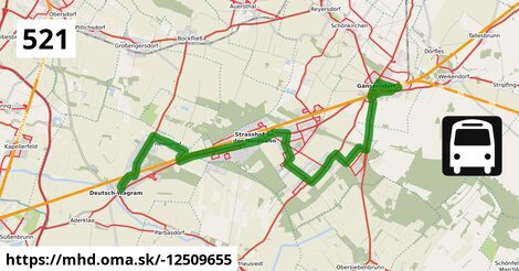
Zastávky na linke, 1 z 2
Deutsch-Wagram Gemeindeamt po ¤,
Deutsch-Wagram Bahnhof po 658 m ¤,
Deutsch-Wagram Eichengasse po 1,29 km ¤,
Helmahof Stefan Fadinger-Straße po 1,59 km ¤,
Helmahof Albrecht-Dürer-Gasse po 1,83 km ¤,
Helmahof Andreas-Reischek-Gasse po 2,1 km ¤,
Helmahof Gottlieb-Fichte-Gasse po 2,4 km ¤,
Helmahof Lindenhof po 3,1 km ¤,
Helmahof Kleistgasse po 3,5 km ¤,
Helmahof Quadenstraße po 3,9 km ¤,
Helmahof Ofnerstraße po 4,2 km ¤,
Helmahof Bahnhof po 4,8 km ¤,
Strasshof Lehárgasse po 7,2 km ¤,
Strasshof Rote Burg po 8,3 km ¤,
Strasshof Billrothgasse po 8,8 km ¤,
Strasshof Petzoldgasse po 9,4 km ¤Zastávky na linke, 2 z 2
Strasshof Anzengrubergasse po 9,9 km ¤,
Strasshof Kleistgasse po 11,0 km ¤,
Strasshof Promenadestraße po 11,4 km ¤,
Strasshof Grenzstraße 3 po 12,3 km ¤,
Gänserndorf Süd Forstgasse po 12,6 km ¤,
Gänserndorf Süd Blumengasse po 13,1 km ¤,
Gänserndorf Süd Äußere-Jochen-Straße po 13,4 km ¤,
Gänserndorf Süd Volksschule po 14,6 km ¤,
Gänserndorf Süd Silberwaldstraße po 15 km ¤,
Gänserndorf Süd Föhrenweg po 16 km ¤,
Gänserndorf Süd Fuchsenwaldstraße po 16 km ¤,
Gänserndorf Süd Waldheimstraße po 17 km ¤,
Gänserndorf Siebenbrunner Straße po 19 km ¤,
Gänserndorf Bahnhof po 21 km ¤,
autobusová zastávka po 22 km ¤Zastávky popri linke:, 1 z 2
Deutsch-Wagram Gemeindeamt po ¤,
Deutsch-Wagram Gemeindeamt po 66 m ¤,
Deutsch-Wagram Bahnhof po 658 m ¤,
Deutsch-Wagram Bahnhof po 667 m ¤,
Deutsch-Wagram Eichengasse po 1,29 km ¤,
Deutsch-Wagram Eichengasse po 1,29 km ¤,
Helmahof Stefan Fadinger-Straße po 1,57 km ¤,
Helmahof Stefan Fadinger-Straße po 1,59 km ¤,
Helmahof Albrecht-Dürer-Gasse po 1,83 km ¤,
Helmahof Albrecht-Dürer-Gasse po 1,84 km ¤,
Helmahof Andreas-Reischek-Gasse po 2,1 km ¤,
Helmahof Andreas-Reischek-Gasse po 2,1 km ¤,
Helmahof Gottlieb-Fichte-Gasse po 2,4 km ¤,
Helmahof Gottlieb-Fichte-Gasse po 2,4 km ¤,
Helmahof Lindenhof po 3,1 km ¤,
Helmahof Lindenhof po 3,2 km ¤,
Helmahof Kleistgasse po 3,5 km ¤,
Helmahof Kleistgasse po 3,5 km ¤,
Helmahof Quadenstraße po 3,9 km ¤,
Helmahof Quadenstraße po 3,9 km ¤,
Helmahof Ofnerstraße po 4,2 km ¤,
Helmahof Ofnerstraße po 4,2 km ¤,
Helmahof Bahnhof po 4,8 km ¤,
Helmahof Bahnhof po 4,8 km ¤,
Strasshof Industriestraße po 6,2 km ¤Zastávky popri linke:, 2 z 2
Strasshof Lehárgasse po 7,1 km ¤,
Strasshof Lehárgasse po 7,2 km ¤,
Strasshof Rote Burg po 8,3 km ¤,
Strasshof Rote Burg po 8,3 km ¤,
Strasshof Billrothgasse po 8,7 km ¤,
Strasshof Billrothgasse po 8,8 km ¤,
Strasshof Petzoldgasse po 9,4 km ¤,
Strasshof Petzoldgasse po 9,4 km ¤,
Strasshof Anzengrubergasse po 9,9 km ¤,
Strasshof Anzengrubergasse po 9,9 km ¤,
Strasshof Kleistgasse po 11,0 km ¤,
Strasshof Kleistgasse po 11,0 km ¤,
Strasshof Promenadestraße po 11,4 km ¤,
Strasshof Promenadestraße po 11,4 km ¤,
Strasshof Grenzstraße 3 po 12,2 km ¤,
Strasshof Grenzstraße 3 po 12,3 km ¤,
Gänserndorf Süd Forstgasse po 12,6 km ¤,
Gänserndorf Süd Forstgasse po 12,7 km ¤,
Gänserndorf Süd Blumengasse po 13,1 km ¤,
Gänserndorf Süd Blumengasse po 13,1 km ¤,
Gänserndorf Süd Äußere-Jochen-Straße po 13,4 km ¤,
Gänserndorf Süd Volksschule po 14,6 km ¤,
Gänserndorf Süd Volksschule po 14,7 km ¤,
Gänserndorf Süd Silberwaldstraße po 15 km ¤,
Gänserndorf Süd Silberwaldstraße po 15 km ¤Automaty na lístky:
Trafik po 22 km ¤Má spoločné úseky s linkami:
Bus 554: Orth an der Donau Gemeindeamt = > Deutsch-Wagram Bahnhof po 592 m ¤ ,
Bus 554: Deutsch-Wagram Bahnhof = > Orth an der Donau Schlossplatz po 592 m ¤ ,
Bus 554: Leopoldsdorf im Marchfeld Rathausplatz = > Deutsch-Wagram Bahnhof po 592 m ¤ ,
Bus 554: Orth an der Donau Schlossplatz = > Deutsch-Wagram Bahnhof po 592 m ¤ ,
Bus 522: Aderklaa Dorfanger = > Deutsch-Wagram Bahnhof po 592 m ¤ ,
Bus 521: Helmahof Gottlieb-Fichte-Gasse = > Deutsch-Wagram po 0,96 km ¤ ,
Bus 520: Kollnbrunn Brünner Straße = > Wien Aderklaaer Straße po 1,08 km ¤ ,
Bus 520: Bad Pirawarth Kurzentrum = > Wien Aderklaaer Straße po 1,08 km ¤ ,
Bus 520: Wien Aderklaaer Straße = > Kollnbrunn Brünner Straße po 1,08 km ¤ ,
Bus 520: Wien Aderklaaer Straße = > Bad Pirawarth Kurzentrum po 1,08 km ¤ ,
Bus 521: Deutsch-Wagram = > Helmahof Bahnhof po 1,08 km ¤ ,
Bus 520: Deutsch-Wagram Gemeindeamt = > Auersthal Schulen po 1,08 km ¤ ,
Bus 521: Helmahof Bahnhof = > Deutsch-Wagram po 1,08 km ¤ ,
Bus 521: Helmahof Bahnhof = > Deutsch-Wagram (nicht über Helmahof Gottlieb-Fichte-Gasse) po 1,08 km ¤ ,
Bus 520: Wien Aderklaaer Straße = > Raggendorf Busbahnhof po 1,08 km ¤ ,
Bus 520: Raggendorf Busbahnhof = > Wien Aderklaaer Straße po 1,08 km ¤ ,
Bus 522: Aderklaa Dorfanger = > Helmahof Bahnhof po 4,8 km ¤ ,
Bus 523: Schulcampus = > Anzengrubergasse po 6,0 km ¤ ,
Bus 521: Deutsch-Wagram = > Gänserndorf Süd Volksschule po 7,0 km ¤ ,
Bus 532: Strasshof Lehárgasse = > Matzen Schule po 8,4 km ¤ ,
Bus 523: Industriestraße = > Schulcampus po 8,4 km ¤ ,
Bus 532: Schönkirchen Volksschule = > Reyersdorf Hauptstraße = > Strasshof Lehargasse po 8,6 km ¤ ,
Bus 524: Strasshof Industriestraße = > Gänserndorf Busbahnhof po 8,6 km ¤ ,
Bus 532: Matzen Schule = > Strasshof Lehargasse po 8,6 km ¤ ,
Bus 532: Matzen Schule = > Auersthal Schulen = > Strasshof Lehargasse po 8,6 km ¤ ,
Bus 523: Anton-Fromm-Gasse = > Schulcampus po 8,6 km ¤ ,
Bus 523: Albert-Sever-Straße = > Schulcampus po 10,2 km ¤ ,
Bus 523: Schulcampus = > Silberwald po 10,3 km ¤ ,
Bus 523: Werndlgasse = > Schulcampus po 10,3 km ¤ ,
Bus 523: Sillerstraße = > Schulcampus po 11,0 km ¤ ,
Bus 524: Gänserndorf Süd Volksschule = > Strasshof Werndlgasse = > Gänserndorf Süd Habichtweg po 12,1 km ¤ ,
Bus 524: Strasshof Werndlgasse = > Gänserndorf Busbahnhof po 12,1 km ¤ ,
Bus 524: Gänserndorf Hans-Kudlich-Gasse = > Strasshof Werndlgasse po 12,1 km ¤ ,
Bus 551: Gänserndorf = > Groß-Enzersdorf po 14,6 km ¤ ,
Bus 524: Gänserndorf Süd Waldweg = > Gänserndorf Süd Eschenweg = > Gänserndorf Süd Volksschule po 14,7 km ¤ ,
Bus 521: Deutsch-Wagram = > Gänserndorf Bahnhof po 19 km ¤ ,
Bus 521: Gänserndorf = > Deutsch-Wagram po 19 km ¤ ,
Bus 521: Gänserndorf = > Deutsch-Wagram (nicht über Helmahof Andreas-Reischek-Gasse) po 19 km ¤ ,
Bus 525: Gänserndorf Lagerhausstraße = > Gänserndorf Volksschule po 19 km ¤ ,
Bus 525: Gänserndorf Bockfließer Weg = > Gänserndorf Volksschule po 19 km ¤ ,
Bus 534: Hohenruppersdorf Gemeindeamt = > Gänserndorf Siebenbrunner Straße po 19 km ¤ ,
Bus 525: Gänserndorf Volksschule = > Gänserndorf Rathausplatz po 20 km ¤ ,
Bus 521: Deutsch-Wagram = > Gänserndorf Bahnhof po 20 km ¤ ,
Bus 531: Gänserndorf Bahnhof = > Auersthal Schulen po 20 km ¤ ,
Bus 531: Gänserndorf Bahnhof = > Wolkersdorf Bahnhof po 20 km ¤ ,
Bus 531: Gänserndorf Bahnhof = > Wolkersdorf Mittelschule po 20 km ¤ ,
Bus 537: Dürnkrut Bahnhof = > Matzen Schule = > Gänserndorf Bahnhof po 21 km ¤ ,
Bus 526: Ollersdorf Tallesbrunner Straße = > Gänserndorf Bbf po 21 km ¤ ,
Bus 537: Ebenthal Stillfrieder Straße = > Gänserndorf Bahnhof po 21 km ¤ ,
Bus 537: Ebenthal Stillfrieder Straße = > OMV = > Gänserndorf Bahnhof po 21 km ¤ ,
Bus 537: Dürnkrut Bahnhof = > Gänserndorf Bahnhof po 21 km ¤ ,
Bus 526: Gänserndorf Hans-Kudlich-Gasse = > Angern/March Bahnhof (ohne Dörfles) po 21 km ¤ ,
Bus 526: Gänserndorf Hans-Kudlich-Gasse = > Ebenthal Stillfrieder Straße po 21 km ¤ ,
Bus 526: Angern an der March Bahnhof = > Gänserndorf Bbf (ohne Dörfles) po 21 km ¤ ,
Bus 526: Angern an der March Marktplatz = > Gänserndorf Bbf po 21 km ¤ ,
Bus 528: Gänserndorf Hans-Kudlich-Gasse = > Weikendorf Volksschule (ohne Halt in Gänserndorf Schillergasse, Grillparzergasse) po 21 km ¤ ,
Bus 528: Gänserndorf Hans-Kudlich-Gasse = > Baumgarten/March Ortsmitte po 21 km ¤ ,
Bus 528: Gänserndorf Hans-Kudlich-Gasse = > Baumgarten/March Ortsmitte (ohne Halt in Gänserndorf Schillergasse, Grillparzergasse) po 21 km ¤ ,
Bus 528: Gänserndorf Hans-Kudlich-Gasse = > Markthof Nr. 10 po 21 km ¤ ,
Bus 528: Weikendorf Volksschule = > Gänserndorf Bahnhof po 21 km ¤ ,
Bus 528: Marchegg Fünfhaus = > Gänserndorf Bahnhof po 21 km ¤ ,
Bus 528: Zwerndorf Ortsmitte = > Gänserndorf Bahnhof po 21 km ¤ ,
Bus 528: Gänserndorf Bahnhof = > Zwerndorf Ortsmitte po 21 km ¤ ,
Bus 528: Gänserndorf Bahnhof = > Weikendorf Volksschule po 21 km ¤ ,
Bus 528: Gänserndorf Bahnhof = > Marchegg Fünfhaus po 21 km ¤ ,
Bus 546: Stopfenreuth = > Gänserndorf po 21 km ¤ ,
Bus 536: Dürnkrut Bahnhof = > Gänserndorf Busbahnhof po 21 km ¤ ,
Bus 524: Gänserndorf Volksschule = > Gänserndorf Bahnhof po 21 km ¤ ,
Bus 534: Zistersdorf Schloßplatz = > Gänserndorf Bahnhof po 21 km ¤ ,
Bus 536: Spannberg Hauptplatz = > Gänserndorf Busbahnhof po 21 km ¤ ,
Bus 530: Gänserndorf Bahnhof = > Wolkersdorf Wiener Straße po 21 km ¤ ,
Bus 530: Gänserndorf Bahnhof = > Auersthal Europa-Siedlung = > Wolkersdorf Wiener Straße po 21 km ¤ ,
Bus 546: Gänserndorf = > Stopfenreuth po 21 km ¤ ,
Bus 531: Wolkersdorf Gymnasium = > Auersthal Europa-Siedlung = > Gänserndorf Bahnhof po 21 km ¤ ,
Bus 531: Wolkersdorf Gymnasium = > Gänserndorf Bahnhof po 21 km ¤ ,
Bus 531: Auersthal Schulen = > Schönkirchen Volksschule = > Gänserndorf Bahnhof po 21 km ¤ ,
Bus 531: Auersthal Schulen = > Gänserndorf Bahnhof po 21 km ¤ ,
Bus 524: Strasshof Kleistgasse = > Gänserndorf Bahnhof po 21 km ¤ ,
Bus 524: Strasshof Werndlgasse = > Gänserndorf Bahnhof po 21 km ¤ ,
Bus 524: Strasshof Grenzstraße 3 = > Gänserndorf Bahnhof po 21 km ¤ ,
Bus 537: Gänserndorf Bahnhof = > Matzen Schule po 21 km ¤ ,
Bus 537: Gänserndorf Bahnhof = > Ebenthal Stillfrieder Straße po 21 km ¤ ,
Bus 537: Gänserndorf Bahnhof = > Ebenthal Stillfrieder Straße (ohne Matzen) po 21 km ¤ ,
Bus 537: Gänserndorf Bahnhof = > OMV = > Ebenthal Stillfrieder Straße po 21 km ¤ ,
Bus 537: Gänserndorf Bahnhof = > Dürnkrut Bahnhof po 21 km ¤ ,
Bus 530: Wolkersdorf Bahnhof = > Gänserndorf Bahnhof po 21 km ¤ ,
Bus 525: Gänserndorf Volksschule = > Gänserndorf Flurgasse po 21 km ¤ ,
Bus 528: Oberweiden Gemeindeamt = > Gänserndorf Busbahnhof po 21 km ¤ ,
Bus 545: Gänserndorf = > Haringsee po 21 km ¤ ,
Bus 545: Gänserndorf = > Orth an der Donau po 21 km ¤ ,
Bus 528: Markthof Nr. 10 = > Gänserndorf Busbahnhof po 21 km ¤ ,
Bus 545: Gänserndorf = > Orth an der Donau Biotech Campus = > Orth an der Donau po 21 km ¤ ,
Bus 546: Gänserndorf = > Markthof = > Stopfenreuth po 21 km ¤ ,
Bus 105: St. Pölten Landhaus Nord = > Gänserndorf Bahnhof po 21 km ¤ ,
Bus 525: Gänserndorf Bahnhof = > Gänserndorf Volksschule po 21 km ¤ ,
Bus 105: Gänserndorf Bahnhof = > St. Pölten Hauptbahnhof Nord po 21 km ¤ ,
Bus 535: Gänserndorf Bahnhof = > Mistelbach Bahnhof po 21 km ¤ ,
Bus 535: Gänserndorf Bahnhof = > Mistelbach Bahnhof po 21 km ¤ ,
Bus 535: Mistelbach Bahnhof = > Gänserndorf Bahnhof po 21 km ¤ ,
Bus 524: Gänserndorf Bahnhof = > Strasshof Werndlgasse = > Gänserndorf Süd Habichtweg po 21 km ¤ ,
Bus 524: Gänserndorf Volksschule = > Strasshof Werndlgasse po 21 km ¤ ,
Bus 524: Gänserndorf Volksschule = > Gänserndorf Süd Eschenweg = > Strasshof Werndlgasse po 21 km ¤ ,
Bus 545: Haringsee = > Gänserndorf po 21 km ¤ ,
Bus 545: Orth an der Donau = > Gänserndorf po 21 km ¤ ,
Bus 551: Groß Enzersdorf Volksschule = > Gänserndorf Busbahnhof po 22 km ¤ ,
Bus 551: Groß-Enzersdorf Auvorstadt = > Gänserndorf Busbahnhof po 22 km ¤ ,
Bus 536: Gänserndorf Bahnhof = > Spannberg Hauptplatz po 22 km ¤ ,
Bus 534: Gänserndorf Bahnhof = > Zistersdorf Schloßplatz po 22 km ¤ ,
Bus 536: Gänserndorf Bahnhof = > Dürnkrut Bahnhof po 22 km ¤ Podobné linky 521:
ine: Bus 521: Gänserndorf = > Deutsch-Wagram, ,
ine: Bus 521: Limbach = > Pezinok, ,
ine: Bus 521: Helmahof Bahnhof = > Deutsch-Wagram, ,
ine: Bus 521: Deutsch-Wagram = > Gänserndorf Süd Volksschule, ,
ine: Bus 521: Deutsch-Wagram = > Gänserndorf Bahnhof, ,
ine: 521, ,
ine: Bus 521: Deutsch-Wagram = > Gänserndorf Bahnhof, ,
ine: Bus 521: Helmahof Gottlieb-Fichte-Gasse = > Deutsch-Wagram, ,
ine: Bus 521: Deutsch-Wagram = > Helmahof Bahnhof, ,
ine: Bus 521: Helmahof Bahnhof = > Deutsch-Wagram (nicht über Helmahof Gottlieb-Fichte-Gasse), ,
ine: Bus 521: Pezinok = > Limbach, ,
ine: Bus 521, ,
ine: Bus 521: Gänserndorf = > Deutsch-Wagram (nicht über Helmahof Andreas-Reischek-Gasse),
Viac info:
aktualizovať mapu,
uprav v JOSM (pokročilé),
-12509655,
stiahni GPX, route: bus, to: Gänserndorf Busbahnhof, from: Deutsch Wagram Gemeindeamt, network: VOR, route name: Bus 521: Deutsch Wagram => Gänserndorf, osm version: 31, osm changeset: 0, osm timestamp: 2026 01 12T03:35:49Z, Q2516485, de:Verkehrsverbund Ost Region, 2, dlzka: 22474, pocet seg: 1, lon: 16.6542, lat: 48.3167, povodna farba: dr. richard no,
Zdroj dát
Mapové údaje pochádzajú z
www.OpenStreetMap.org, databáza je prístupná pod licenciou
ODbL.

Mapový podklad vytvára a aktualizuje
Freemap Slovakia (www.freemap.sk), šíriteľný pod licenciou CC-BY-SA. Fotky sme čerpali z galérie portálu freemap.sk, autori fotiek sú uvedení pri jednotlivých fotkách a sú šíriteľné pod licenciou CC a z wikipédie. Výškový profil trás čerpáme z
SRTM. Niečo vám chýba?
Pridajte to. Sme radi, že tvoríte slobodnú wiki mapu sveta.