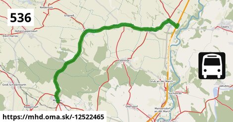
Zastávky na linke
Matzen Schule po ¤, Matzen Hauptplatz po 378 m ¤, Spannberg Sportplatz po 7,3 km ¤, Spannberg Matzner Straße po 7,7 km ¤, Spannberg Hauptplatz po 8,2 km ¤, Spannberg Neugasse po 8,8 km ¤, Velm-Götzendorf Hauptstraße 18/23 po 10,9 km ¤, Velm-Götzendorf Hauptstraße 66/73 po 11,7 km ¤, Velm-Götzendorf Ortsmitte po 12,4 km ¤, Velm-Götzendorf Feldstraße po 13,1 km ¤, Velm-Götzendorf Vorstadt po 13,4 km ¤, Waidendorf Am Alten Friedhof po 15 km ¤, Dürnkrut Badsiedlung po 17 km ¤, Dürnkrut Schulen po 18 km ¤, Dürnkrut Bahnhof po 19 km ¤Zastávky popri linke:
Matzen Schule po ¤, Matzen Hauptplatz po 346 m ¤, Matzen Hauptplatz po 378 m ¤, Spannberg Sportplatz po 7,3 km ¤, Spannberg Sportplatz po 7,3 km ¤, Spannberg Matzner Straße po 7,7 km ¤, Spannberg Matzner Straße po 7,7 km ¤, Spannberg Hauptplatz po 8,2 km ¤, Spannberg Neugasse po 8,8 km ¤, Spannberg Neugasse po 8,8 km ¤, Velm-Götzendorf Hauptstraße 18/23 po 10,9 km ¤, Velm-Götzendorf Hauptstraße 18/23 po 11,0 km ¤, Velm-Götzendorf Hauptstraße 66/73 po 11,7 km ¤, Velm-Götzendorf Hauptstraße 66/73 po 11,7 km ¤, Velm-Götzendorf Ortsmitte po 12,4 km ¤, Velm-Götzendorf Ortsmitte po 12,4 km ¤, Velm-Götzendorf Feldstraße po 13,1 km ¤, Velm-Götzendorf Feldstraße po 13,2 km ¤, Velm-Götzendorf Vorstadt po 13,4 km ¤, Velm-Götzendorf Vorstadt po 13,4 km ¤, Waidendorf Am Alten Friedhof po 15 km ¤, Waidendorf Am Alten Friedhof po 15 km ¤, Dürnkrut Badsiedlung po 17 km ¤, Dürnkrut Badsiedlung po 17 km ¤, Dürnkrut Schulen po 18 km ¤, Dürnkrut Schulen po 18 km ¤, Dürnkrut Bahnhof po 19 km ¤prestupné linky:
Bus 532: Strasshof Lehárgasse = > Matzen Schule po ¤, Bus 532: Matzen Schule = > Strasshof Lehargasse po 19 m ¤, Bus 537: Gänserndorf Bahnhof = > Matzen Schule po 117 m ¤, railjet: Praha = > Wien = > Villach po 19 km ¤, NJ 457: Berlin = > Graz po 19 km ¤, EN 407: Praha - Wien po 19 km ¤, REX1: Břeclav = > Wiener Neustadt po 19 km ¤, EuroCity Warszawa – Wien po 19 km ¤, REX1: Wiener Neustadt = > Břeclav po 19 km ¤, EuroCity Wien – Warszawa po 19 km ¤, EN 40406: Wien - Praha po 19 km ¤, railjet: Villach = > Wien = > Praha po 19 km ¤Má spoločné úseky s linkami:
Bus 536: Gänserndorf Bahnhof = > Dürnkrut Bahnhof po 33 m ¤ , Bus 537: Gänserndorf Bahnhof = > OMV = > Ebenthal Stillfrieder Straße po 33 m ¤ , Bus 537: Gänserndorf Bahnhof = > Ebenthal Stillfrieder Straße po 33 m ¤ , Bus 537: Matzen Schule = > Ebenthal Stillfrieder Straße po 33 m ¤ , Bus 534: Matzen Schule = > Hohenruppersdorf Marktplatz po 352 m ¤ , Bus 534: Gänserndorf Bahnhof = > Zistersdorf Schloßplatz po 352 m ¤ , Bus 534: Raggendorf Hauptstraße = > Matzen Schule po 352 m ¤ , Bus 532: Matzen Schule = > Auersthal Schulen = > Strasshof Lehargasse po 352 m ¤ , Bus 534: Hohenruppersdorf Gemeindeamt = > Gänserndorf Siebenbrunner Straße po 352 m ¤ , Bus 534: Matzen Schule = > Zistersdorf Schloßplatz po 352 m ¤ , Bus 534: Matzen Schule = > Obersulz Ortsmitte po 352 m ¤ , Bus 530: Gänserndorf Bahnhof = > Auersthal Europa-Siedlung = > Wolkersdorf Wiener Straße po 352 m ¤ , Bus 530: Gänserndorf Bahnhof = > Wolkersdorf Wiener Straße po 352 m ¤ , Bus 530: Wolkersdorf Bahnhof = > Gänserndorf Bahnhof po 352 m ¤ , Bus 530: Gänserndorf Bahnhof = > Auersthal Europa-Siedlung = > Wolkersdorf Wiener Straße po 352 m ¤ , Bus 530: Gänserndorf Bahnhof = > Wolkersdorf Wiener Straße po 352 m ¤ , Bus 530: Wolkersdorf Wiener Straße = > Gänserndorf Bahnhof po 352 m ¤ , Bus 530: Raggendorf Busbahnhof = > Gänserndorf Bahnhof po 352 m ¤ , Bus 534: Zistersdorf Schloßplatz = > Gänserndorf Bahnhof po 7,4 km ¤ , Bus 536: Reyersdorf Kirche = > Spannberg Hauptplatz po 7,4 km ¤ , Bus 536: Gänserndorf Bahnhof = > Spannberg Hauptplatz po 7,4 km ¤ , Bus 536: Spannberg Hauptplatz = > Reyersdorf Hauptstraße po 7,4 km ¤ , Bus 536: Spannberg Hauptplatz = > Gänserndorf Busbahnhof po 7,4 km ¤ , Bus 565: Mistelbach Bahnhof = > Spannberg Hauptplatz po 8,2 km ¤ , Bus 573: Altlichtenwarth Neusiedler Straße = > Hollabrunn Internat po 13,2 km ¤ , Bus 573: Hollabrunn Internat = > Altlichtenwarth Neusiedler Straße po 17 km ¤ , Bus 564: Mistelbach Bahnhof = > Drösing Bahnhof (ohne Mistelbach Hauptplatz, Drösing Kaiser-Josef-Platz) po 18 km ¤ , Bus 564: Mistelbach Bahnhof = > Drösing Bahnhof (ohne Großinzersdorf) po 18 km ¤ , Bus 564: Dürnkrut Bahnhof = > Wilfersdorf bei Mistelbach Wirtschaftspark = > Mistelbach Hauptplatz = > Mistelbach Bahnhof po 18 km ¤ , Bus 564: Dürnkrut Bahnhof = > Wilfersdorf Wirtschaftspark = > Mistelbach Bahnhof po 18 km ¤ , Bus 564: Drösing Bahnhof = > Zistersdorf Kaiserstraße (ohne Großinzersdorf) po 18 km ¤ , Bus 564: Drösing Bahnhof = > Mistelbach Bahnhof po 18 km ¤ , Bus 564: Drösing Bahnhof = > Drösing Kaiser-Josef-Platz = > Wilfersdorf bei Mistelbach Wirtschaftspark = > Mistelbach Bahnhof po 18 km ¤ , Bus 564: Drösing Bahnhof = > Drösing Kaiser-Josef-Platz = > Mistelbach Bahnhof po 18 km ¤ , Bus 564: Drösing Bahnhof = > Mistelbach Bahnhof (ohne Kettlasbrunn) po 18 km ¤ , Bus 565: Niedersulz Kirche = > Dürnkrut Bahnhof po 18 km ¤ , Bus 565: Mistelbach Bahnhof = > Dürnkrut Bahnhof po 18 km ¤ , Bus 565: Mistelbach Bahnhof = > Niedersulz Museumsdorf = > Dürnkrut Bahnhof po 18 km ¤ , Bus 565: Mistelbach Bahnhof = > Ebenthal = > Dürnkrut Bahnhof po 18 km ¤ , Bus 565: Dürnkrut Bahnhof = > Spannberg Hauptplatz po 18 km ¤ , Bus 565: Dürnkrut Bahnhof = > Niedersulz Kirche po 18 km ¤ , Bus 565: Dürnkrut Bahnhof = > Mistelbach Bahnhof po 18 km ¤ , Bus 565: Dürnkrut Bahnhof = > Niedersulz Museumsdorf = > Mistelbach Bahnhof po 18 km ¤ , Bus 537: Dürnkrut Bahnhof = > Ebenthal Florianiplatz po 18 km ¤ , Bus 537: Dürnkrut Bahnhof = > Matzen Schule = > Gänserndorf Bahnhof po 18 km ¤ , Bus 537: Matzen Schule = > Dürnkrut Bahnhof po 18 km ¤ , Bus 537: Dürnkrut Bahnhof = > Gänserndorf Bahnhof po 18 km ¤ , Bus 537: Dürnkrut Bahnhof = > Prottes Volksschule po 18 km ¤ , Bus 537: Gänserndorf Bahnhof = > Dürnkrut Bahnhof po 18 km ¤ , Bus 537: Ebenthal Florianiplatz = > Dürnkrut Bahnhof po 18 km ¤ , Bus 536: Dürnkrut Bahnhof = > Gänserndorf Busbahnhof po 18 km ¤ , Bus 564: Zistersdorf Schloßplatz = > Drösing Bahnhof (ohne Drösing Kaiser-Josef-Platz) po 18 km ¤ , Bus 564: Mistelbach Hauptplatz = > Mistelbach Alleegasse = > Drösing Bahnhof po 18 km ¤ , Bus 564: Mistelbach Bahnhof = > Dürnkrut Bahnhof po 18 km ¤ , Bus 564: Mistelbach Bahnhof = > Dürnkrut Bahnhof (ohne Mistelbach Hauptplatz) po 18 km ¤ , Bus 564: Mistelbach Bahnhof = > Drösing Bahnhof po 18 km ¤ , Bus 564: Mistelbach Bahnhof = > Mistelbach Wirtschaftspark = > Drösing Bahnhof po 18 km ¤Trasa vedie cez obce
Gemeinde Spannberg: 5,4 km (28.1 %), Gemeinde Dürnkrut: 4,7 km (24.4 %), Gemeinde Velm-Götzendorf: 3,7 km (19.3 %), Gemeinde Matzen-Raggendorf: 3,6 km (18.8 %), Gemeinde Hohenruppersdorf: 1,81 km (9.4 %),

Podobné linky 536:
ine: Bus 536: Gänserndorf Bahnhof = > Dürnkrut Bahnhof, , ine: Bus 536: Spannberg Hauptplatz = > Reyersdorf Hauptstraße, , ine: Bus 536: Reyersdorf Kirche = > Spannberg Hauptplatz, , ine: Bus 536: Gänserndorf Bahnhof = > Spannberg Hauptplatz, , ine: Bus 536: Dürnkrut Bahnhof = > Gänserndorf Busbahnhof, , ine: Bus 536: Spannberg Hauptplatz = > Gänserndorf Busbahnhof,Viac info: aktualizovať mapu, uprav v JOSM (pokročilé), -12522465, stiahni GPX, route: bus, to: Dürnkrut Bahnhof, from: Matzen Schule, network: VOR, route name: Bus 536: Matzen Schule => Dürnkrut Bahnhof, osm version: 9, osm changeset: 0, osm timestamp: 2025 11 03T16:08:50Z, Q2516485, 2, dlzka: 19261, pocet seg: 1, lon: 16.7628, lat: 48.4532, povodna farba: dr. richard no,