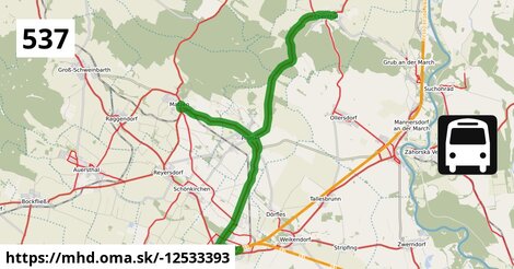
Zastávky na linke
Gänserndorf Bahnhof po ¤, Gänserndorf Hans-Kudlich-Gasse po 1,20 km ¤, autobusová zastávka po 1,54 km ¤, Gänserndorf Augasse po 2,3 km ¤, Prottes Friedensgasse po 6,3 km ¤, Prottes Volksschule po 6,7 km ¤, Prottes Lerchengasse po 7,3 km ¤, Matzen Hofgartenstraße po 10,6 km ¤, Matzen Schule po 11,3 km ¤, Prottes Lerchengasse po 15 km ¤, Prottes Dörfleser Straße po 16 km ¤, Ebenthal Florianiplatz po 24 km ¤, Ebenthal Stillfrieder Straße po 25 km ¤Zastávky popri linke:
Gänserndorf Bahnhof po ¤, Gänserndorf Bahnhof po 5 m ¤, Gänserndorf Bahnhof po 15 m ¤, Gänserndorf Villagasse po 101 m ¤, Trafik po 0,86 km ¤, Gänserndorf Hans-Kudlich-Gasse po 1,20 km ¤, autobusová zastávka po 1,52 km ¤, autobusová zastávka po 1,54 km ¤, Busbahnhof Gänserndorf po 1,56 km ¤, autobusová zastávka po 1,56 km ¤, autobusová zastávka po 1,59 km ¤, autobusová zastávka po 1,61 km ¤, autobusová zastávka po 1,64 km ¤, Gänserndorf Rathausplatz po 1,72 km ¤, Gänserndorf Rathausplatz po 1,76 km ¤, Gänserndorf Augasse po 2,2 km ¤, Gänserndorf Augasse po 2,3 km ¤, Prottes Friedensgasse po 6,2 km ¤, Prottes Friedensgasse po 6,3 km ¤, Prottes Volksschule po 6,7 km ¤, Prottes Volksschule po 6,7 km ¤, Prottes Lerchengasse po 7,3 km ¤, Matzen Hofgartenstraße po 10,6 km ¤, Matzen Hofgartenstraße po 10,6 km ¤, Matzen Schule po 11,3 km ¤, Prottes Lerchengasse po 15 km ¤, Prottes Dörfleser Straße po 16 km ¤, Ebenthal Florianiplatz po 24 km ¤, Ebenthal Stillfrieder Straße po 25 km ¤prestupné linky:
Bus 524: Strasshof Werndlgasse = > Gänserndorf Busbahnhof po 1,46 km ¤, Bus 524: Strasshof Industriestraße = > Gänserndorf Busbahnhof po 1,46 km ¤, Bus 551: Groß Enzersdorf Volksschule = > Gänserndorf Busbahnhof po 1,46 km ¤, Bus 551: Groß-Enzersdorf Auvorstadt = > Gänserndorf Busbahnhof po 1,46 km ¤, Bus 551: Gänserndorf = > Groß-Enzersdorf po 1,62 km ¤, Bus 525: Gänserndorf Lagerhausstraße = > Gänserndorf VolksschuleMá spoločné úseky s linkami:
Bus 528: Gänserndorf Bahnhof = > Zwerndorf Ortsmitte po 21 m ¤ , Bus 528: Gänserndorf Bahnhof = > Marchegg Fünfhaus po 21 m ¤ , Bus 528: Gänserndorf Bahnhof = > Weikendorf Volksschule po 21 m ¤ , Bus 545: Haringsee = > Gänserndorf po 27 m ¤ , Bus 546: Stopfenreuth = > Gänserndorf po 27 m ¤ , Bus 545: Orth an der Donau = > Gänserndorf po 27 m ¤ , Bus 528: Weikendorf Volksschule = > Gänserndorf Bahnhof po 200 m ¤ , Bus 105: Gänserndorf Bahnhof = > St. Pölten Hauptbahnhof Nord po 200 m ¤ , Bus 528: Zwerndorf Ortsmitte = > Gänserndorf Bahnhof po 200 m ¤ , Bus 521: Deutsch-Wagram = > Gänserndorf Bahnhof po 200 m ¤ , Bus 521: Deutsch-Wagram = > Gänserndorf Bahnhof po 200 m ¤ , Bus 524: Gänserndorf Volksschule = > Gänserndorf Bahnhof po 200 m ¤ , Bus 528: Marchegg Fünfhaus = > Gänserndorf Bahnhof po 200 m ¤ , Bus 524: Gänserndorf Bahnhof = > Strasshof Werndlgasse = > Gänserndorf Süd Habichtweg po 234 m ¤ , Bus 525: Gänserndorf Volksschule = > Gänserndorf Flurgasse po 255 m ¤ , Bus 105: St. Pölten Landhaus Nord = > Gänserndorf Bahnhof po 312 m ¤ , Bus 531: Wolkersdorf Gymnasium = > Gänserndorf Bahnhof po 312 m ¤ , Bus 531: Auersthal Schulen = > Schönkirchen Volksschule = > Gänserndorf Bahnhof po 312 m ¤ , Bus 531: Auersthal Schulen = > Gänserndorf Bahnhof po 312 m ¤ , Bus 524: Gänserndorf Volksschule = > Gänserndorf Süd Eschenweg = > Strasshof Werndlgasse po 312 m ¤ , Bus 524: Gänserndorf Volksschule = > Strasshof Werndlgasse po 312 m ¤ , Bus 545: Gänserndorf = > Haringsee po 312 m ¤ , Bus 545: Gänserndorf = > Orth an der Donau po 312 m ¤ , Bus 545: Gänserndorf = > Orth an der Donau Biotech Campus = > Orth an der Donau po 312 m ¤ , Bus 524: Strasshof Kleistgasse = > Gänserndorf Bahnhof po 312 m ¤ , Bus 524: Strasshof Werndlgasse = > Gänserndorf Bahnhof po 312 m ¤ , Bus 524: Strasshof Grenzstraße 3 = > Gänserndorf Bahnhof po 312 m ¤ , Bus 521: Deutsch-Wagram = > Gänserndorf po 312 m ¤ , Bus 521: Gänserndorf = > Deutsch-Wagram po 312 m ¤ , Bus 521: Gänserndorf = > Deutsch-Wagram (nicht über Helmahof Andreas-Reischek-Gasse) po 312 m ¤ , Bus 528: Markthof Nr. 10 = > Gänserndorf Busbahnhof po 312 m ¤ , Bus 546: Gänserndorf = > Stopfenreuth po 312 m ¤ , Bus 536: Gänserndorf Bahnhof = > Dürnkrut Bahnhof po 312 m ¤ , Bus 536: Gänserndorf Bahnhof = > Spannberg Hauptplatz po 312 m ¤ , Bus 546: Gänserndorf = > Markthof = > Stopfenreuth po 312 m ¤ , Bus 530: Gänserndorf Bahnhof = > Auersthal Europa-Siedlung = > Wolkersdorf Wiener Straße po 312 m ¤ , Bus 530: Gänserndorf Bahnhof = > Wolkersdorf Wiener Straße po 312 m ¤ , Bus 530: Wolkersdorf Bahnhof = > Gänserndorf Bahnhof po 312 m ¤ , Bus 528: Oberweiden Gemeindeamt = > Gänserndorf Busbahnhof po 312 m ¤ , Bus 525: Gänserndorf Bahnhof = > Gänserndorf Volksschule po 312 m ¤ , Bus 531: Wolkersdorf Gymnasium = > Auersthal Europa-Siedlung = > Gänserndorf Bahnhof po 312 m ¤ , Bus 535: Gänserndorf Bahnhof = > Mistelbach Bahnhof po 360 m ¤ , Bus 535: Gänserndorf Bahnhof = > Mistelbach Bahnhof po 360 m ¤ , Bus 537: Gänserndorf Bahnhof = > Matzen Schule po 450 m ¤ , Bus 537: Gänserndorf Bahnhof = > Ebenthal Stillfrieder Straße (ohne Matzen) po 450 m ¤ , Bus 537: Gänserndorf Bahnhof = > OMV = > Ebenthal Stillfrieder Straße po 450 m ¤ , Bus 535: Mistelbach Bahnhof = > Gänserndorf Bahnhof po 450 m ¤ , Bus 537: Gänserndorf Bahnhof = > Dürnkrut Bahnhof po 450 m ¤ , Bus 534: Gänserndorf Bahnhof = > Zistersdorf Schloßplatz po 450 m ¤ , Bus 528: Gänserndorf Hans-Kudlich-Gasse = > Markthof Nr. 10 po 1,51 km ¤ , Bus 524: Gänserndorf Hans-Kudlich-Gasse = > Strasshof Werndlgasse po 1,51 km ¤ , Bus 528: Gänserndorf Hans-Kudlich-Gasse = > Weikendorf Volksschule (ohne Halt in Gänserndorf Schillergasse, Grillparzergasse) po 1,51 km ¤ , Bus 528: Gänserndorf Hans-Kudlich-Gasse = > Baumgarten/March Ortsmitte po 1,51 km ¤ , Bus 528: Gänserndorf Hans-Kudlich-Gasse = > Baumgarten/March Ortsmitte (ohne Halt in Gänserndorf Schillergasse, Grillparzergasse) po 1,51 km ¤ , Bus 526: Gänserndorf Hans-Kudlich-Gasse = > Ebenthal Stillfrieder Straße po 1,51 km ¤ , Bus 526: Gänserndorf Hans-Kudlich-Gasse = > Angern/March Bahnhof (ohne Dörfles) po 1,51 km ¤ , Bus 531: Gänserndorf Busbahnhof = > Auersthal Schulen po 1,72 km ¤ , Bus 531: Gänserndorf Bahnhof = > Wolkersdorf Mittelschule po 1,74 km ¤ , Bus 531: Gänserndorf Bahnhof = > Wolkersdorf Bahnhof po 1,74 km ¤ , Bus 531: Gänserndorf Bahnhof = > Auersthal Schulen po 1,74 km ¤ , Bus 525: Gänserndorf Volksschule = > Gänserndorf Rathausplatz po 1,85 km ¤ , Bus 526: Angern an der March Marktplatz = > Gänserndorf Bbf po 1,90 km ¤ , Bus 534: Hohenruppersdorf Gemeindeamt = > Gänserndorf Siebenbrunner Straße po 1,90 km ¤ , Bus 537: Dürnkrut Bahnhof = > Matzen Schule = > Gänserndorf Bahnhof po 1,90 km ¤ , Bus 534: Zistersdorf Schloßplatz = > Gänserndorf Bahnhof po 1,90 km ¤ , Bus 526: Ollersdorf Tallesbrunner Straße = > Gänserndorf Bbf po 1,90 km ¤ , Bus 526: Angern an der March Bahnhof = > Gänserndorf Bbf (ohne Dörfles) po 1,90 km ¤ , Bus 536: Spannberg Hauptplatz = > Gänserndorf Busbahnhof po 11,0 km ¤ , Bus 536: Dürnkrut Bahnhof = > Gänserndorf Busbahnhof po 11,0 km ¤ , Bus 534: Matzen Schule = > Zistersdorf Schloßplatz po 11,1 km ¤ , Bus 536: Matzen Schule = > Dürnkrut Bahnhof po 11,1 km ¤ , Bus 532: Matzen Schule = > Auersthal Schulen = > Strasshof Lehargasse po 11,1 km ¤ , Bus 534: Matzen Schule = > Hohenruppersdorf Marktplatz po 11,1 km ¤ , Bus 534: Matzen Schule = > Obersulz Ortsmitte po 11,1 km ¤ , Bus 536: Spannberg Hauptplatz = > Reyersdorf Hauptstraße po 11,2 km ¤ , Bus 536: Reyersdorf Kirche = > Spannberg Hauptplatz po 11,2 km ¤ , Bus 532: Strasshof Lehárgasse = > Matzen Schule po 11,2 km ¤ , Bus 534: Raggendorf Hauptstraße = > Matzen Schule po 11,2 km ¤ , Bus 530: Wolkersdorf Wiener Straße = > Gänserndorf Bahnhof po 11,3 km ¤ , Bus 530: Gänserndorf Bahnhof = > Wolkersdorf Wiener Straße po 11,3 km ¤ , Bus 530: Raggendorf Busbahnhof = > Gänserndorf Bahnhof po 11,3 km ¤ , Bus 530: Gänserndorf Bahnhof = > Auersthal Europa-Siedlung = > Wolkersdorf Wiener Straße po 11,3 km ¤ , Bus 532: Matzen Schule = > Strasshof Lehargasse po 11,3 km ¤ , Bus 537: Dürnkrut Bahnhof = > Prottes Volksschule po 24 km ¤ , Bus 537: Ebenthal Stillfrieder Straße = > Gänserndorf Bahnhof po 24 km ¤ , Bus 537: Ebenthal Stillfrieder Straße = > Prottes Volksschule po 24 km ¤ , Bus 537: Prottes Volksschule = > Ebenthal Stillfrieder Straße (ohne Matzen) po 24 km ¤ , Bus 537: Matzen Schule = > Ebenthal Stillfrieder Straße po 24 km ¤ , Bus 537: Dürnkrut Bahnhof = > Gänserndorf Bahnhof po 24 km ¤ , Bus 537: Ebenthal Stillfrieder Straße = > OMV = > Gänserndorf Bahnhof po 24 km ¤ , Bus 565: Mistelbach Bahnhof = > Ebenthal = > Dürnkrut Bahnhof po 24 km ¤ , Bus 537: Matzen Schule = > Dürnkrut Bahnhof po 24 km ¤ , Bus 537: Ebenthal Florianiplatz = > Dürnkrut Bahnhof po 24 km ¤ , Bus 537: Dürnkrut Bahnhof = > Ebenthal Florianiplatz po 24 km ¤Trasa vedie cez obce
Gemeinde Prottes: 7,4 km (29.8 %), Gemeinde Gänserndorf: 5,9 km (23.8 %), Ebenthal: 4,5 km (18.2 %), Gemeinde Matzen-Raggendorf: 2,5 km (10 %),
Podobné linky 537:
ine: Bus 537: Prottes Volksschule = > Ebenthal Stillfrieder Straße (ohne Matzen), , ine: Bus 537: Matzen Schule = > Ebenthal Stillfrieder Straße, , ine: Bus 537: Gänserndorf Bahnhof = > Ebenthal Stillfrieder Straße (ohne Matzen), , ine: Bus 537: Ebenthal Florianiplatz = > Dürnkrut Bahnhof, , ine: Bus 537: Ebenthal Stillfrieder Straße = > Gänserndorf Bahnhof, , ine: Bus 537: Dürnkrut Bahnhof = > Ebenthal Florianiplatz, , ine: Bus 537: Gänserndorf Bahnhof = > Matzen Schule, , ine: Bus 537: Dürnkrut Bahnhof = > Matzen Schule = > Gänserndorf Bahnhof, , ine: Bus 537: Ebenthal Stillfrieder Straße = > Prottes Volksschule, , ine: Bus 537: Dürnkrut Bahnhof = > Prottes Volksschule, , ine: Bus 537: Dürnkrut Bahnhof = > Gänserndorf Bahnhof, , ine: Bus 537: Ebenthal Stillfrieder Straße = > OMV = > Gänserndorf Bahnhof, , ine: Bus 537: Gänserndorf Bahnhof = > OMV = > Ebenthal Stillfrieder Straße, , ine: Bus 537: Gänserndorf Bahnhof = > Dürnkrut Bahnhof, , ine: Bus 537: Matzen Schule = > Dürnkrut Bahnhof,Viac info: aktualizovať mapu, uprav v JOSM (pokročilé), -12533393, stiahni GPX, route: bus, to: Ebenthal Stillfrieder Straße, from: Gänserndorf Bahnhof, network: VOR, route name: Bus 537: Gänserndorf Bahnhof => Ebenthal Stillfrieder Straße, osm version: 17, osm changeset: 0, osm timestamp: 2024 04 09T16:52:29Z, Q2516485, de:Verkehrsverbund Ost Region, 2, dlzka: 24887, pocet seg: 1, lon: 16.7359, lat: 48.3902, povodna farba: dr. richard,