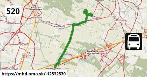
Zastávky na linke
Deutsch-Wagram Gemeindeamt po ¤,
Deutsch-Wagram Bahnhof po 0,71 km ¤,
Deutsch-Wagram Eichengasse po 1,40 km ¤,
Helmahof Stefan Fadinger-Straße po 1,73 km ¤,
Helmahof Albrecht-Dürer-Gasse po 1,98 km ¤,
Helmahof Andreas-Reischek-Gasse po 2,3 km ¤,
Helmahof Gottlieb-Fichte-Gasse po 2,6 km ¤,
Bockfließ Wagramer Straße po 7,4 km ¤,
Bockfließ Kirche po 7,7 km ¤,
Bockfließ Hauptstraße 94/101 po 8,1 km ¤,
Bockfließ Althofstraße po 8,3 km ¤,
Auersthal Kirchlissen po 10,6 km ¤,
Auersthal Urbanusplatz po 11,0 km ¤,
Auersthal Europa-Siedlung po 12,2 km ¤,
Auersthal Hauptstraße po 13,3 km ¤,
Auersthal Schulen po 14,6 km ¤Zastávky popri linke:, 1 z 2
Deutsch-Wagram Gemeindeamt po ¤,
Deutsch-Wagram Gemeindeamt po 72 m ¤,
Deutsch-Wagram Bahnhof po 0,71 km ¤,
Deutsch-Wagram Bahnhof po 0,72 km ¤,
Deutsch-Wagram Eichengasse po 1,40 km ¤,
Deutsch-Wagram Eichengasse po 1,40 km ¤,
Helmahof Stefan Fadinger-Straße po 1,70 km ¤,
Helmahof Stefan Fadinger-Straße po 1,73 km ¤,
Helmahof Albrecht-Dürer-Gasse po 1,98 km ¤,
Helmahof Albrecht-Dürer-Gasse po 2,00 km ¤,
Helmahof Andreas-Reischek-Gasse po 2,3 km ¤,
Helmahof Andreas-Reischek-Gasse po 2,3 km ¤,
Helmahof Gottlieb-Fichte-Gasse po 2,6 km ¤,
Helmahof Gottlieb-Fichte-Gasse po 2,7 km ¤,
Bockfließ Wagramer Straße po 7,4 km ¤,
Bockfließ Wagramer Straße po 7,4 km ¤Zastávky popri linke:, 2 z 2
Bockfließ Kirche po 7,7 km ¤,
Bockfließ Kirche po 7,7 km ¤,
Bockfließ Hauptstraße 94/101 po 8,1 km ¤,
Bockfließ Hauptstraße 94/101 po 8,1 km ¤,
Bockfließ Althofstraße po 8,3 km ¤,
Bockfließ Althofstraße po 8,3 km ¤,
Auersthal Kirchlissen po 10,6 km ¤,
Auersthal Kirchlissen po 10,6 km ¤,
Auersthal Urbanusplatz po 11,0 km ¤,
Auersthal Urbanusplatz po 11,0 km ¤,
Auersthal Europa-Siedlung po 12,2 km ¤,
Auersthal Hauptstraße po 13,3 km ¤,
Auersthal Hauptstraße po 13,3 km ¤,
Auersthal Raggendorfer Straße po 13,9 km ¤,
Auersthal Raggendorfer Straße po 13,9 km ¤,
Auersthal Schulen po 14,6 km ¤Má spoločné úseky s linkami:
Bus 554: Deutsch-Wagram Bahnhof = > Orth an der Donau Schlossplatz po 642 m ¤ ,
Bus 554: Orth an der Donau Gemeindeamt = > Deutsch-Wagram Bahnhof po 642 m ¤ ,
Bus 554: Leopoldsdorf im Marchfeld Rathausplatz = > Deutsch-Wagram Bahnhof po 642 m ¤ ,
Bus 554: Orth an der Donau Schlossplatz = > Deutsch-Wagram Bahnhof po 642 m ¤ ,
Bus 522: Aderklaa Dorfanger = > Deutsch-Wagram Bahnhof po 642 m ¤ ,
Bus 521: Helmahof Gottlieb-Fichte-Gasse = > Deutsch-Wagram po 1,04 km ¤ ,
Bus 521: Helmahof Bahnhof = > Deutsch-Wagram po 1,18 km ¤ ,
Bus 521: Helmahof Bahnhof = > Deutsch-Wagram (nicht über Helmahof Gottlieb-Fichte-Gasse) po 1,18 km ¤ ,
Bus 521: Gänserndorf = > Deutsch-Wagram po 1,18 km ¤ ,
Bus 521: Deutsch-Wagram = > Gänserndorf po 1,18 km ¤ ,
Bus 521: Gänserndorf = > Deutsch-Wagram (nicht über Helmahof Andreas-Reischek-Gasse) po 1,18 km ¤ ,
Bus 521: Deutsch-Wagram = > Gänserndorf Bahnhof po 1,18 km ¤ ,
Bus 521: Deutsch-Wagram = > Helmahof Bahnhof po 1,18 km ¤ ,
Bus 521: Deutsch-Wagram = > Gänserndorf Süd Volksschule po 1,18 km ¤ ,
Bus 530: Wolkersdorf Wiener Straße = > Gänserndorf Bahnhof po 7,4 km ¤ ,
Bus 530: Wolkersdorf Bahnhof = > Gänserndorf Bahnhof po 7,4 km ¤ ,
Bus 531: Bockfließ Althofstraße = > Wolkersdorf Mittelschule po 7,5 km ¤ ,
Bus 105: Gänserndorf Bahnhof = > St. Pölten Hauptbahnhof Nord po 8,3 km ¤ ,
Bus 105: St. Pölten Landhaus Nord = > Gänserndorf Bahnhof po 8,3 km ¤ ,
Bus 531: Wolkersdorf Volksschule = > Reyersdorf Hauptstraße po 8,3 km ¤ ,
Bus 531: Gänserndorf Bahnhof = > Wolkersdorf Bahnhof po 11,5 km ¤ ,
Bus 531: Gänserndorf Bahnhof = > Wolkersdorf Mittelschule po 11,5 km ¤ ,
Bus 531: Auersthal Raggendorfer Straße = > Wolkersdorf Volksschule po 13,6 km ¤ ,
Bus 520: Bad Pirawarth Kurzentrum = > Wien Aderklaaer Straße po 13,9 km ¤ ,
Bus 531: Wolkersdorf Gymnasium = > Auersthal Europa-Siedlung = > Gänserndorf Bahnhof po 13,9 km ¤ ,
Bus 531: Wolkersdorf Mittelschule = > Auersthal Schulen po 13,9 km ¤ ,
Bus 531: Auersthal Schulen = > Schönkirchen Volksschule = > Gänserndorf Bahnhof po 13,9 km ¤ ,
Bus 531: Auersthal Schulen = > Reyersdorf Hauptstraße po 13,9 km ¤ ,
Bus 531: Auersthal Schulen = > Gänserndorf Bahnhof po 13,9 km ¤ ,
Bus 520: Raggendorf Busbahnhof = > Wien Aderklaaer Straße po 13,9 km ¤ ,
Bus 520: Wien Aderklaaer Straße = > Raggendorf Busbahnhof po 13,9 km ¤ ,
Bus 530: Gänserndorf Bahnhof = > Wolkersdorf Wiener Straße po 13,9 km ¤ ,
Bus 532: Matzen Schule = > Auersthal Schulen = > Strasshof Lehargasse po 13,9 km ¤ ,
Bus 520: Wien Aderklaaer Straße = > Kollnbrunn Brünner Straße po 13,9 km ¤ ,
Bus 520: Wien Aderklaaer Straße = > Bad Pirawarth Kurzentrum po 13,9 km ¤ ,
Bus 520: Kollnbrunn Brünner Straße = > Wien Aderklaaer Straße po 13,9 km ¤ ,
Bus 530: Gänserndorf Bahnhof = > Wolkersdorf Wiener Straße po 13,9 km ¤ ,
Bus 530: Gänserndorf Bahnhof = > Auersthal Europa-Siedlung = > Wolkersdorf Wiener Straße po 14,0 km ¤ ,
Bus 531: Wolkersdorf Gymnasium = > Gänserndorf Bahnhof po 14,0 km ¤ ,
Bus 530: Gänserndorf Bahnhof = > Auersthal Europa-Siedlung = > Wolkersdorf Wiener Straße po 14,0 km ¤ ,
Bus 531: Wolkersdorf Mittelschule = > Reyersdorf Hauptstraße po 14,0 km ¤ ,
Bus 531: Wolkersdorf Bahnhof = > Auersthal Am Anger po 14,0 km ¤ ,
Bus 531: Gänserndorf Bahnhof = > Auersthal Schulen po 14,6 km ¤ ,
Bus 531: Gänserndorf Busbahnhof = > Auersthal Schulen po 14,6 km ¤ Podobné linky 520:
ine: Bus 520: Wien Aderklaaer Straße = > Raggendorf Busbahnhof, ,
ine: Bus 520, ,
ine: Bus 520: Raggendorf Busbahnhof = > Wien Aderklaaer Straße, ,
ine: Bus 520: Bratislava = > Pezinok, Nemocnica, ,
ine: Bus 520: Kollnbrunn Brünner Straße = > Wien Aderklaaer Straße, ,
ine: Bus 520: Wien Aderklaaer Straße = > Kollnbrunn Brünner Straße, ,
ine: Bus 520: Bad Pirawarth Kurzentrum = > Wien Aderklaaer Straße, ,
ine: Bus 520: Wien Aderklaaer Straße = > Bad Pirawarth Kurzentrum, ,
ine: 520, ,
ine: Bus 520: Pezinok, Nemocnica = > Bratislava,
Viac info:
aktualizovať mapu,
uprav v JOSM (pokročilé),
-12532530,
stiahni GPX, route: bus, to: Auersthal Schulen, from: Deutsch Wagram Gemeindeamt, network: VOR, route name: Bus 520: Deutsch Wagram Gemeindeamt => Auersthal Schulen, osm version: 23, osm changeset: 0, osm timestamp: 2026 06 14T22:04:40Z, Q2516485, 2, dlzka: 14572, pocet seg: 1, lon: 16.6040, lat: 48.3479, povodna farba: dr. richard no,
Zdroj dát
Mapové údaje pochádzajú z
www.OpenStreetMap.org, databáza je prístupná pod licenciou
ODbL.

Mapový podklad vytvára a aktualizuje
Freemap Slovakia (www.freemap.sk), šíriteľný pod licenciou CC-BY-SA. Fotky sme čerpali z galérie portálu freemap.sk, autori fotiek sú uvedení pri jednotlivých fotkách a sú šíriteľné pod licenciou CC a z wikipédie. Výškový profil trás čerpáme z
SRTM. Niečo vám chýba?
Pridajte to. Sme radi, že tvoríte slobodnú wiki mapu sveta.