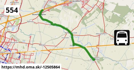
Zastávky na linke
Leopoldsdorf im Marchfeld Rathausplatz po 2 m ¤,
Glinzendorf Kirche po 5,4 km ¤,
Markgrafneusiedl Altes Dorf 29/68 po 7,1 km ¤,
Markgrafneusiedl Gemeindeamt po 7,4 km ¤,
Parbasdorf Ortsmitte po 11,3 km ¤,
Deutsch-Wagram Theodor Körner-Gasse po 14,7 km ¤,
Deutsch-Wagram Gemeindeamt po 14,9 km ¤,
Deutsch-Wagram Bahnhof po 16 km ¤Zastávky popri linke:
Leopoldsdorf im Marchfeld Rathausplatz po 2 m ¤,
Leopoldsdorf im Marchfeld Rathausplatz po 241 m ¤,
Glinzendorf Kirche po 5,4 km ¤,
Markgrafneusiedl Altes Dorf 29/68 po 7,0 km ¤,
Markgrafneusiedl Altes Dorf 29/68 po 7,1 km ¤,
Markgrafneusiedl Gemeindeamt po 7,4 km ¤,
Markgrafneusiedl Gemeindeamt po 7,4 km ¤,
Parbasdorf Ortsmitte po 11,3 km ¤,
Deutsch-Wagram Theodor Körner-Gasse po 14,7 km ¤,
Deutsch-Wagram Theodor Körner-Gasse po 14,7 km ¤,
Deutsch-Wagram Gemeindeamt po 14,9 km ¤,
Deutsch-Wagram Gemeindeamt po 14,9 km ¤,
Deutsch-Wagram Bahnhof po 16 km ¤,
Deutsch-Wagram Bahnhof po 16 km ¤Má spoločné úseky s linkami:
Bus 545: Gänserndorf = > Orth an der Donau Biotech Campus = > Orth an der Donau po 54 m ¤ ,
Bus 545: Obersiebenbrunn = > Orth an der Donau po 54 m ¤ ,
Bus 545: Gänserndorf = > Haringsee po 54 m ¤ ,
Bus 545: Gänserndorf = > Orth an der Donau po 54 m ¤ ,
Bus 541: Siebenbrunn-Leopoldsdorf = > Schönfeld im Marchfeld Hauptstraße po 54 m ¤ ,
Bus 541: Siebenbrunn-Leopoldsdorf = > Schönfeld-Lassee po 54 m ¤ ,
Bus 554: Leopoldsdorf im Marchfeld Rathausplatz = > Großhofen Landesstraße po 3,0 km ¤ ,
Bus 554: Großhofen Landesstraße = > Orth/Donau Gemeindeamt po 3,0 km ¤ ,
Bus 551: Gänserndorf = > Groß-Enzersdorf po 5,2 km ¤ ,
Bus 551: Groß-Enzersdorf Auvorstadt = > Gänserndorf Busbahnhof po 5,2 km ¤ ,
Bus 551: Groß Enzersdorf Volksschule = > Gänserndorf Busbahnhof po 5,2 km ¤ ,
Bus 540: Obersiebenbrunn Marktplatz = > Wien Aspern Nord po 7,3 km ¤ ,
Bus 540: Wien Hausfeldstraße = > Schloßhof po 7,3 km ¤ ,
Bus 540: Schloßhof = > Wien Aspern Nord po 7,3 km ¤ ,
Bus 554: Orth an der Donau Gemeindeamt = > Deutsch-Wagram Bahnhof po 11,5 km ¤ ,
Bus 554: Orth an der Donau Schlossplatz = > Deutsch-Wagram Bahnhof po 11,5 km ¤ ,
Bus 554: Deutsch-Wagram Bahnhof = > Orth an der Donau Schlossplatz po 11,5 km ¤ ,
Bus 522: Deutsch-Wagram Gemeindeamt = > Parbasdorf Ortsmitte = > Aderklaa Dorfanger po 13,9 km ¤ ,
Bus 520: Wien Aderklaaer Straße = > Raggendorf Busbahnhof po 14,6 km ¤ ,
Bus 522: Aderklaa Dorfanger = > Deutsch-Wagram Bahnhof po 14,6 km ¤ ,
Bus 520: Wien Aderklaaer Straße = > Bad Pirawarth Kurzentrum po 14,6 km ¤ ,
Bus 520: Bad Pirawarth Kurzentrum = > Wien Aderklaaer Straße po 14,6 km ¤ ,
Bus 520: Raggendorf Busbahnhof = > Wien Aderklaaer Straße po 14,6 km ¤ ,
Bus 520: Kollnbrunn Brünner Straße = > Wien Aderklaaer Straße po 14,6 km ¤ ,
Bus 520: Wien Aderklaaer Straße = > Kollnbrunn Brünner Straße po 14,6 km ¤ ,
Bus 522: Deutsch-Wagram = > Aderklaa Dorfanger po 14,8 km ¤ ,
Bus 522: Aderklaa Dorfanger = > Helmahof Bahnhof po 14,8 km ¤ ,
Bus 521: Deutsch-Wagram = > Gänserndorf po 15 km ¤ ,
Bus 521: Gänserndorf = > Deutsch-Wagram po 15 km ¤ ,
Bus 521: Helmahof Gottlieb-Fichte-Gasse = > Deutsch-Wagram po 15 km ¤ ,
Bus 521: Helmahof Bahnhof = > Deutsch-Wagram (nicht über Helmahof Gottlieb-Fichte-Gasse) po 15 km ¤ ,
Bus 521: Helmahof Bahnhof = > Deutsch-Wagram po 15 km ¤ ,
Bus 521: Gänserndorf = > Deutsch-Wagram (nicht über Helmahof Andreas-Reischek-Gasse) po 15 km ¤ ,
Bus 521: Deutsch-Wagram = > Gänserndorf Süd Volksschule po 15 km ¤ ,
Bus 521: Deutsch-Wagram = > Helmahof Bahnhof po 15 km ¤ ,
Bus 520: Deutsch-Wagram Gemeindeamt = > Auersthal Schulen po 15 km ¤ ,
Bus 521: Deutsch-Wagram = > Gänserndorf Bahnhof po 15 km ¤ Podobné linky 554:
ine: Bus 554: Orlová, Lutyně, aut. nádr. = > Ostrava, Kunčice, NH jižní brána, ,
ine: Bus 554: Orth an der Donau Schlossplatz = > Deutsch-Wagram Bahnhof, ,
ine: Bus 554: Großhofen Landesstraße = > Orth/Donau Gemeindeamt, ,
ine: Bus 554: Deutsch-Wagram Bahnhof = > Orth an der Donau Schlossplatz, ,
ine: Bus 554: Orth an der Donau Gemeindeamt = > Deutsch-Wagram Bahnhof, ,
ine: Bus 554: Ostrava, Kunčice, NH jižní brána = > Orlová, Lutyně, aut. nádr., ,
ine: Bus 554: Leopoldsdorf im Marchfeld Rathausplatz = > Großhofen Landesstraße,
Viac info:
aktualizovať mapu,
uprav v JOSM (pokročilé),
-12505864,
stiahni GPX, route: bus, to: Deutsch Wagram Bahnhof, from: Leopoldsdorf im Marchfeld Rathausplatz, network: VOR, route name: Bus 554: Leopoldsdorf im Marchfeld Rathausplatz => Deutsch Wagram Bahnhof, osm version: 14, osm changeset: 0, osm timestamp: 2026 01 12T03:35:49Z, Q2516485, de:Verkehrsverbund Ost Region, 2, dlzka: 15516, pocet seg: 1, lon: 16.6224, lat: 48.2643, povodna farba: dr. richard no,
Zdroj dát
Mapové údaje pochádzajú z
www.OpenStreetMap.org, databáza je prístupná pod licenciou
ODbL.

Mapový podklad vytvára a aktualizuje
Freemap Slovakia (www.freemap.sk), šíriteľný pod licenciou CC-BY-SA. Fotky sme čerpali z galérie portálu freemap.sk, autori fotiek sú uvedení pri jednotlivých fotkách a sú šíriteľné pod licenciou CC a z wikipédie. Výškový profil trás čerpáme z
SRTM. Niečo vám chýba?
Pridajte to. Sme radi, že tvoríte slobodnú wiki mapu sveta.