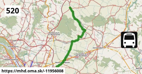
Zastávky na linke
Kollnbrunn Brünner Straße po ¤,
Bad Pirawarth Kirchensteg po 389 m ¤,
Bad Pirawarth Rathaus po 1,26 km ¤,
Bad Pirawarth Untere Hauptstraße po 1,80 km ¤,
Groß Schweinbarth Fürstengarten po 6,0 km ¤,
Groß Schweinbarth Gemeindeamt po 6,4 km ¤,
Groß Schweinbarth Schloss po 6,7 km ¤,
Raggendorf Hauptstraße po 9,6 km ¤,
autobusová zastávka po 10,4 km ¤,
Auersthal Raggendorfer Straße po 12,6 km ¤,
Auersthal Hauptstraße po 13,3 km ¤,
Auersthal Urbanusplatz po 13,7 km ¤,
Auersthal Kirchlissen po 14,1 km ¤,
Bockfließ Althofstraße po 16 km ¤,
Bockfließ Hauptstraße 94/101 po 17 km ¤,
Bockfließ Kirche po 17 km ¤,
Bockfließ Wagramer Straße po 17 km ¤,
Helmahof Gottlieb-Fichte-Gasse po 22 km ¤,
Helmahof Andreas-Reischek-Gasse po 22 km ¤,
Helmahof Albrecht-Dürer-Gasse po 23 km ¤,
Helmahof Stefan Fadinger-Straße po 23 km ¤,
Deutsch-Wagram Eichengasse po 23 km ¤,
Deutsch-Wagram Bahnhof po 24 km ¤,
Deutsch-Wagram Gemeindeamt po 25 km ¤,
Deutsch-Wagram Theodor Körner-Gasse po 25 km ¤,
Aderklaa Dorfanger po 27 km ¤Zastávky popri linke:, 1 z 2
Kollnbrunn Brünner Straße po ¤,
Kollnbrunn Brünner Straße po ¤,
Bad Pirawarth Kirchensteg po 389 m ¤,
Bad Pirawarth Kirchensteg po 417 m ¤,
Bad Pirawarth Rathaus po 1,26 km ¤,
Bad Pirawarth Rathaus po 1,26 km ¤,
Bad Pirawarth Untere Hauptstraße po 1,80 km ¤,
Bad Pirawarth Untere Hauptstraße po 1,80 km ¤,
Groß Schweinbarth Fürstengarten po 6,0 km ¤,
Groß Schweinbarth Fürstengarten po 6,0 km ¤,
Groß Schweinbarth Gemeindeamt po 6,4 km ¤,
Groß Schweinbarth Gemeindeamt po 6,4 km ¤,
Groß Schweinbarth Schloss po 6,7 km ¤,
Groß Schweinbarth Schloss po 6,7 km ¤,
Raggendorf Hauptstraße po 9,6 km ¤,
Raggendorf Hauptstraße po 9,6 km ¤,
autobusová zastávka po 10,4 km ¤,
autobusová zastávka po 10,4 km ¤,
autobusová zastávka po 10,5 km ¤,
Auersthal Raggendorfer Straße po 12,6 km ¤,
Auersthal Raggendorfer Straße po 12,6 km ¤,
Auersthal Hauptstraße po 13,3 km ¤,
Auersthal Hauptstraße po 13,3 km ¤,
Auersthal Urbanusplatz po 13,7 km ¤,
Auersthal Urbanusplatz po 13,7 km ¤Zastávky popri linke:, 2 z 2
Auersthal Kirchlissen po 14,1 km ¤,
Auersthal Kirchlissen po 14,1 km ¤,
Bockfließ Althofstraße po 16 km ¤,
Bockfließ Althofstraße po 16 km ¤,
Bockfließ Hauptstraße 94/101 po 17 km ¤,
Bockfließ Hauptstraße 94/101 po 17 km ¤,
Bockfließ Kirche po 17 km ¤,
Bockfließ Kirche po 17 km ¤,
Bockfließ Wagramer Straße po 17 km ¤,
Bockfließ Wagramer Straße po 17 km ¤,
Helmahof Gottlieb-Fichte-Gasse po 22 km ¤,
Helmahof Gottlieb-Fichte-Gasse po 22 km ¤,
Helmahof Andreas-Reischek-Gasse po 22 km ¤,
Helmahof Andreas-Reischek-Gasse po 22 km ¤,
Helmahof Albrecht-Dürer-Gasse po 23 km ¤,
Helmahof Albrecht-Dürer-Gasse po 23 km ¤,
Helmahof Stefan Fadinger-Straße po 23 km ¤,
Helmahof Stefan Fadinger-Straße po 23 km ¤,
Deutsch-Wagram Eichengasse po 23 km ¤,
Deutsch-Wagram Eichengasse po 23 km ¤,
Deutsch-Wagram Bahnhof po 24 km ¤,
Deutsch-Wagram Bahnhof po 24 km ¤,
Deutsch-Wagram Gemeindeamt po 25 km ¤,
Deutsch-Wagram Gemeindeamt po 25 km ¤,
Deutsch-Wagram Theodor Körner-Gasse po 25 km ¤prestupné linky:
Bus 150: Bernhardsthal Bahnhof = > Wien Floridsdorf po ¤,
Bus 500: Mistelbach Bahnhof = > Wien Floridsdorf po 13 m ¤,
Bus 500: Schrick Hobersdorfer Straße = > Wien Floridsdorf po 13 m ¤,
Bus 500: Schrick Hobersdorfer Straße = > Wolkersdorf Bahnhof po 13 m ¤,
Bus 500: Wien Floridsdorf = > Schrick Hobersdorfer Straße po 13 m ¤,
Bus 500: Wien Floridsdorf = > Mistelbach Bahnhof po 13 m ¤,
Bus 150: Wien Floridsdorf = > Bernhardsthal Bahnhof po 13 m ¤,
Bus 500: Wolkersdorf Bahnhof = > Gaweinstal Hauptplatz po 13 m ¤,
Bus 531: Gänserndorf Bahnhof = > Auersthal Schulen po 12,6 km ¤,
Bus 531: Gänserndorf Busbahnhof = > Auersthal Schulen po 12,6 km ¤Má spoločné úseky s linkami:
Bus 505: Zistersdorf Schloßplatz = > Wolkersdorf Bahnhof po ¤ ,
Bus 505: Zistersdorf Schloßplatz = > Wien Floridsdorf po ¤ ,
Bus 505: Zistersdorf Schloßplatz = > Niedersulz Museumsdorf = > Wien Floridsdorf po ¤ ,
Bus 505: Zistersdorf Schloßplatz = > Obersulz Ortsmitte = > Niedersulz Museumsdorf = > Wolkersdorf Bahnhof po ¤ ,
Bus 505: Zistersdorf Schloßplatz = > Obersulz Ortsmitte = > Niedersulz Museumsdorf = > Wien Floridsdorf po ¤ ,
Bus 505: Zistersdorf Schloßplatz = > Obersulz Ortsmitte = > Wien Floridsdorf po ¤ ,
Bus 505: Zistersdorf Schloßplatz = > Niedersulz Museumsdorf = > Wolkersdorf Bahnhof po ¤ ,
Bus 520: Wien Aderklaaer Straße = > Kollnbrunn Brünner Straße po 13 m ¤ ,
Bus 571: Klein-Harras Hauptstraße = > Kollnbrunn Brünner Straße po 301 m ¤ ,
Bus 505: Wolkersdorf Bahnhof = > Niedersulz Museumsdorf = > Zistersdorf Schloßplatz po 326 m ¤ ,
Bus 505: Wien Floridsdorf = > Niedersulz Museumsdorf = > Obersulz Ortsmitte = > Zistersdorf Schloßplatz po 326 m ¤ ,
Bus 505: Wien Floridsdorf = > Obersulz Ortsmitte = > Zistersdorf Schloßplatz po 326 m ¤ ,
Bus 505: Wolkersdorf Bahnhof = > Zistersdorf Schloßplatz po 326 m ¤ ,
Bus 505: Wien Floridsdorf = > Zistersdorf Schloßplatz po 326 m ¤ ,
Bus 505: Wien Floridsdorf = > Niedersulz Museumsdorf = > Zistersdorf Schloßplatz po 326 m ¤ ,
Bus 571: Bad Pirawarth = > Gaweinstal Volksschule po 1,19 km ¤ ,
Bus 571: Gaweinstal Volksschule = > Bad Pirawarth Untere Hauptstraße po 1,19 km ¤ ,
Bus 534: Matzen Schule = > Obersulz Ortsmitte po 9,3 km ¤ ,
Bus 534: Raggendorf Hauptstraße = > Matzen Schule po 9,3 km ¤ ,
Bus 534: Matzen Schule = > Zistersdorf Schloßplatz po 9,3 km ¤ ,
Bus 534: Hohenruppersdorf Gemeindeamt = > Gänserndorf Siebenbrunner Straße po 9,3 km ¤ ,
Bus 534: Gänserndorf Bahnhof = > Zistersdorf Schloßplatz po 9,3 km ¤ ,
Bus 534: Matzen Schule = > Hohenruppersdorf Marktplatz po 9,3 km ¤ ,
Bus 535: Mistelbach Bahnhof = > Gänserndorf Bahnhof po 9,5 km ¤ ,
Bus 530: Raggendorf Busbahnhof = > Gänserndorf Bahnhof po 9,6 km ¤ ,
Bus 530: Gänserndorf Bahnhof = > Auersthal Europa-Siedlung = > Wolkersdorf Wiener Straße po 10,3 km ¤ ,
Bus 530: Gänserndorf Bahnhof = > Wolkersdorf Wiener Straße po 10,3 km ¤ ,
Bus 530: Gänserndorf Bahnhof = > Wolkersdorf Wiener Straße po 10,3 km ¤ ,
Bus 530: Gänserndorf Bahnhof = > Auersthal Europa-Siedlung = > Wolkersdorf Wiener Straße po 10,3 km ¤ ,
Bus 535: Gänserndorf Bahnhof = > Mistelbach Bahnhof po 10,4 km ¤ ,
Bus 535: Gänserndorf Bahnhof = > Mistelbach Bahnhof po 10,4 km ¤ ,
Bus 530: Wolkersdorf Bahnhof = > Gänserndorf Bahnhof po 10,5 km ¤ ,
Bus 530: Wolkersdorf Wiener Straße = > Gänserndorf Bahnhof po 10,5 km ¤ ,
Bus 531: Wolkersdorf Mittelschule = > Reyersdorf Hauptstraße po 12,6 km ¤ ,
Bus 531: Wolkersdorf Bahnhof = > Auersthal Am Anger po 12,6 km ¤ ,
Bus 531: Wolkersdorf Mittelschule = > Auersthal Schulen po 12,6 km ¤ ,
Bus 531: Wolkersdorf Gymnasium = > Gänserndorf Bahnhof po 12,6 km ¤ ,
Bus 532: Matzen Schule = > Auersthal Schulen = > Strasshof Lehargasse po 12,6 km ¤ ,
Bus 531: Auersthal Schulen = > Schönkirchen Volksschule = > Gänserndorf Bahnhof po 12,6 km ¤ ,
Bus 531: Auersthal Schulen = > Reyersdorf Hauptstraße po 12,6 km ¤ ,
Bus 531: Auersthal Schulen = > Gänserndorf Bahnhof po 12,6 km ¤ ,
Bus 531: Auersthal Raggendorfer Straße = > Wolkersdorf Volksschule po 12,9 km ¤ ,
Bus 531: Gänserndorf Bahnhof = > Wolkersdorf Bahnhof po 12,9 km ¤ ,
Bus 531: Gänserndorf Bahnhof = > Wolkersdorf Mittelschule po 12,9 km ¤ ,
Bus 105: Gänserndorf Bahnhof = > St. Pölten Hauptbahnhof Nord po 16 km ¤ ,
Bus 531: Wolkersdorf Volksschule = > Reyersdorf Hauptstraße po 16 km ¤ ,
Bus 105: St. Pölten Landhaus Nord = > Gänserndorf Bahnhof po 16 km ¤ ,
Bus 531: Bockfließ Althofstraße = > Wolkersdorf Mittelschule po 17 km ¤ ,
Bus 531: Wolkersdorf Gymnasium = > Auersthal Europa-Siedlung = > Gänserndorf Bahnhof po 17 km ¤ ,
Bus 521: Gänserndorf = > Deutsch-Wagram (nicht über Helmahof Andreas-Reischek-Gasse) po 23 km ¤ ,
Bus 521: Deutsch-Wagram = > Gänserndorf Süd Volksschule po 23 km ¤ ,
Bus 521: Deutsch-Wagram = > Helmahof Bahnhof po 23 km ¤ ,
Bus 521: Deutsch-Wagram = > Gänserndorf Bahnhof po 23 km ¤ ,
Bus 521: Helmahof Bahnhof = > Deutsch-Wagram (nicht über Helmahof Gottlieb-Fichte-Gasse) po 23 km ¤ ,
Bus 521: Helmahof Gottlieb-Fichte-Gasse = > Deutsch-Wagram po 23 km ¤ ,
Bus 521: Gänserndorf = > Deutsch-Wagram po 23 km ¤ ,
Bus 521: Deutsch-Wagram = > Gänserndorf po 23 km ¤ ,
Bus 521: Helmahof Bahnhof = > Deutsch-Wagram po 23 km ¤ ,
Bus 520: Deutsch-Wagram Gemeindeamt = > Auersthal Schulen po 24 km ¤ ,
Bus 520: Raggendorf Busbahnhof = > Wien Aderklaaer Straße po 24 km ¤ ,
Bus 522: Deutsch-Wagram Gemeindeamt = > Parbasdorf Ortsmitte = > Aderklaa Dorfanger po 25 km ¤ ,
Bus 554: Deutsch-Wagram Bahnhof = > Orth an der Donau Schlossplatz po 25 km ¤ ,
Bus 554: Orth an der Donau Gemeindeamt = > Deutsch-Wagram Bahnhof po 25 km ¤ ,
Bus 554: Leopoldsdorf im Marchfeld Rathausplatz = > Deutsch-Wagram Bahnhof po 25 km ¤ ,
Bus 554: Orth an der Donau Schlossplatz = > Deutsch-Wagram Bahnhof po 25 km ¤ ,
Bus 520: Wien Aderklaaer Straße = > Bad Pirawarth Kurzentrum po 25 km ¤ ,
Bus 520: Wien Aderklaaer Straße = > Raggendorf Busbahnhof po 25 km ¤ ,
Bus 520: Bad Pirawarth Kurzentrum = > Wien Aderklaaer Straße po 25 km ¤ ,
Bus 522: Aderklaa Dorfanger = > Deutsch-Wagram Bahnhof po 25 km ¤ ,
Bus 522: Aderklaa Dorfanger = > Helmahof Bahnhof po 25 km ¤ ,
Bus 522: Deutsch-Wagram = > Aderklaa Dorfanger po 25 km ¤ Trasa vedie cez obce
Gemeinde Bockfließ: 4,6 km (16.7 %),
Gemeinde Bad Pirawarth: 4,6 km (16.4 %),
Gemeinde Groß-Schweinbarth: 4,4 km (15.8 %),
Gemeinde Auersthal: 3,4 km (12.2 %),
Gemeinde Matzen-Raggendorf: 2,5 km (9.1 %),
Gemeinde Großengersdorf: 2,0 km (7.3 %),
Gemeinde Aderklaa: 1,54 km (5.5 %),
Podobné linky 520:
ine: Bus 520: Wien Aderklaaer Straße = > Kollnbrunn Brünner Straße, ,
ine: Bus 520: Deutsch-Wagram Gemeindeamt = > Auersthal Schulen, ,
ine: Bus 520: Pezinok, Nemocnica = > Bratislava, ,
ine: Bus 520: Wien Aderklaaer Straße = > Raggendorf Busbahnhof, ,
ine: Bus 520: Bratislava = > Pezinok, Nemocnica, ,
ine: Bus 520, ,
ine: Bus 520: Raggendorf Busbahnhof = > Wien Aderklaaer Straße, ,
ine: Bus 520: Bad Pirawarth Kurzentrum = > Wien Aderklaaer Straße, ,
ine: Bus 520: Wien Aderklaaer Straße = > Bad Pirawarth Kurzentrum, ,
ine: 520,
Viac info:
aktualizovať mapu,
uprav v JOSM (pokročilé),
-11956008,
stiahni GPX, route: bus, to: Wien Aderklaaer Straße, from: Kollnbrunn Brünner Straße, network: VOR, route name: Bus 520: Kollnbrunn Brünner Straße => Wien Aderklaaer Straße, osm version: 41, osm changeset: 0, osm timestamp: 2025 12 19T23:43:28Z, Q2516485, 2, dlzka: 27804, pocet seg: 1, lon: 16.6064, lat: 48.3693, povodna farba: dr. richard no,
Zdroj dát
Mapové údaje pochádzajú z
www.OpenStreetMap.org, databáza je prístupná pod licenciou
ODbL.

Mapový podklad vytvára a aktualizuje
Freemap Slovakia (www.freemap.sk), šíriteľný pod licenciou CC-BY-SA. Fotky sme čerpali z galérie portálu freemap.sk, autori fotiek sú uvedení pri jednotlivých fotkách a sú šíriteľné pod licenciou CC a z wikipédie. Výškový profil trás čerpáme z
SRTM. Niečo vám chýba?
Pridajte to. Sme radi, že tvoríte slobodnú wiki mapu sveta.