Zastávky na linke
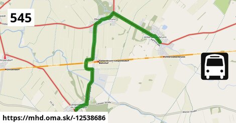
Leopoldsdorf im Marchfeld Rathausplatz po 3 m ¤, Leopoldsdorf/Marchfeld Getreidegasse po 1,06 km ¤, Leopoldsdorf/Marchfeld Zuckerfabrik po 2,2 km ¤, Obersiebenbrunn Prinz-Eugen-Straße po 4,8 km ¤, Obersiebenbrunn Marktplatz po 5,5 km ¤, Obersiebenbrunn Graf-Kollonitsch-Straße po 6,0 km ¤, Untersiebenbrunn Kirchengasse po 8,9 km ¤, Untersiebenbrunn Kellergasse po 9,2 km ¤Zastávky popri linke:
Leopoldsdorf im Marchfeld Rathausplatz po 3 m ¤, Leopoldsdorf/Marchfeld Getreidegasse po 1,06 km ¤, Leopoldsdorf/Marchfeld Getreidegasse po 1,08 km ¤, Regina Ivanics po 1,11 km ¤, Leopoldsdorf/Marchfeld Zuckerfabrik po 2,2 km ¤, Leopoldsdorf/Marchfeld Zuckerfabrik po 2,2 km ¤, Obersiebenbrunn Prinz-Eugen-Straße po 4,8 km ¤, Obersiebenbrunn Prinz-Eugen-Straße po 5,0 km ¤, Obersiebenbrunn Marktplatz po 5,5 km ¤, Obersiebenbrunn Marktplatz po 5,5 km ¤, Obersiebenbrunn Graf-Kollonitsch-Straße po 5,9 km ¤, Obersiebenbrunn Graf-Kollonitsch-Straße po 6,0 km ¤, Untersiebenbrunn Kirchengasse po 8,8 km ¤, Untersiebenbrunn Kirchengasse po 8,9 km ¤, Untersiebenbrunn Kellergasse po 9,1 km ¤, Untersiebenbrunn Kellergasse po 9,2 km ¤prestupné linky:
Bus 554: Leopoldsdorf im Marchfeld Rathausplatz = > Deutsch-Wagram Bahnhof po ¤, Bus 554: Orth an der Donau Schlossplatz = > Deutsch-Wagram Bahnhof po ¤, Bus 554: Orth an der Donau Gemeindeamt = > Deutsch-Wagram Bahnhof po ¤, Bus 554: Großhofen Landesstraße = > Orth/Donau Gemeindeamt po ¤, Bus 554: Deutsch-Wagram Bahnhof = > Orth an der Donau Schlossplatz po ¤, Bus 554: Leopoldsdorf im Marchfeld Rathausplatz = > Großhofen Landesstraße po 57 m ¤Má spoločné úseky s linkami:
Bus 541: Siebenbrunn-Leopoldsdorf = > Schönfeld im Marchfeld Hauptstraße po 566 m ¤ , Bus 541: Siebenbrunn-Leopoldsdorf = > Schönfeld-Lassee po 566 m ¤ , Bus 545: Orth an der Donau = > Gänserndorf po 2,7 km ¤ , Bus 541: Schönfeld-Lassee = > Siebenbrunn-Leopoldsdorf po 2,7 km ¤ , Bus 541: Haringsee Pframastraße = > Siebenbrunn-Leopoldsdorf po 2,7 km ¤ , Bus 545: Haringsee = > Gänserndorf po 2,7 km ¤ , Bus 545: Gänserndorf = > Orth an der Donau Biotech Campus = > Orth an der Donau po 2,9 km ¤ , Bus 545: Obersiebenbrunn = > Orth an der Donau po 2,9 km ¤ , Bus 545: Gänserndorf = > Haringsee po 2,9 km ¤ , Bus 545: Gänserndorf = > Orth an der Donau po 2,9 km ¤ , Bus 540: Schloßhof = > Wien Aspern Nord po 5,3 km ¤ , Bus 540: Wien Hausfeldstraße = > Schloßhof po 5,3 km ¤ , Bus 540: Obersiebenbrunn Marktplatz = > Wien Aspern Nord po 5,5 km ¤ , Bus 546: Stopfenreuth = > Gänserndorf po 5,5 km ¤ , Bus 546: Gänserndorf = > Markthof = > Stopfenreuth po 5,5 km ¤ , Bus 546: Gänserndorf = > Stopfenreuth po 5,5 km ¤ , Bus 546: Obersiebenbrunn Marktplatz = > Stopfenreuth po 5,7 km ¤ , Bus 540: Schloßhof = > Obersiebenbrunn Marktplatz po 5,7 km ¤Trasa vedie cez obce
Gemeinde Obersiebenbrunn: 5,0 km (53.9 %), Gemeinde Leopoldsdorf im Marchfelde: 2,5 km (27.3 %), Gemeinde Untersiebenbrunn: 1,73 km (18.8 %),
Podobné linky 545:
ine: Bus 545: Gänserndorf = > Haringsee, , ine: Bus 545, , ine: Bus 545: Gänserndorf = > Orth an der Donau Biotech Campus = > Orth an der Donau, , ine: Bus 545: Leopoldsdorf im Marchfeld = > Haringsee, , ine: Bus 545: Haringsee = > Orth an der Donau, , ine: Bus 545: Obersiebenbrunn = > Orth an der Donau, , ine: Bus 545: Orth/Donau Wiener Straße = > Haringsee, , ine: Bus 545: Gänserndorf = > Orth an der Donau, , ine: Bus 545: Haringsee = > Gänserndorf, , ine: Bus 545: Pezinok = > Šenkvice = > Budmerice, , ine: Bus 545: Orth an der Donau = > Gänserndorf, , ine: Bus 545: Budmerice = > Šenkvice = > Pezinok,Viac info: aktualizovať mapu, uprav v JOSM (pokročilé), -12538686, stiahni GPX, route: bus, to: Untersiebenbrunn Kellergasse, from: Leopoldsdorf im Marchfeld Rathausplatz, network: VOR, route name: Bus 545: Leopoldsdorf im Marchfeld => Untersiebenbrunn, osm version: 19, osm changeset: 0, osm timestamp: 2026 05 06T15:41:55Z, Q2516485, 2, dlzka: 9222, pocet seg: 1, lon: 16.7106, lat: 48.2516, povodna farba: dr. richard no blaguss,