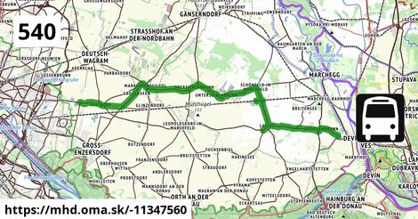
Zastávky na linke
Raasdorf Kirche po 2,7 km ¤,
Großhofen Landesstraße po 7,4 km ¤,
Markgrafneusiedl Gemeindeamt po 8,8 km ¤,
Markgrafneusiedl Altes Dorf 29/68 po 9,2 km ¤,
Obersiebenbrunn Fachschule po 14,7 km ¤,
Obersiebenbrunn Marktplatz po 15 km ¤,
Obersiebenbrunn Graf-Kollonitsch-Straße po 16 km ¤,
Untersiebenbrunn Kirchengasse po 18 km ¤,
Untersiebenbrunn Kellergasse po 19 km ¤,
Schönfeld im Marchfeld Hauptstraße po 23 km ¤,
Schönfeld-Lassee Bahnhof po 26 km ¤,
Lassee Wagramstraße po 27 km ¤,
Lassee Mittelschule po 28 km ¤,
Lassee Kirche po 29 km ¤,
Lassee Pointengasse po 29 km ¤,
Lassee Hagelweg po 31 km ¤,
Lassee Erholungszentrum po 33 km ¤,
Groißenbrunn Schloßhofer Straße po 37 km ¤,
Schloßhof Prinz-Eugen-Straße po 39 km ¤Zastávky popri linke:, 1 z 2
Trafik Raasdorf po 2,7 km ¤,
Raasdorf Kirche po 2,7 km ¤,
Raasdorf Kirche po 2,7 km ¤,
Großhofen Landesstraße po 7,4 km ¤,
Großhofen Landesstraße po 7,4 km ¤,
Markgrafneusiedl Gemeindeamt po 8,8 km ¤,
Markgrafneusiedl Gemeindeamt po 8,8 km ¤,
Markgrafneusiedl Altes Dorf 29/68 po 9,2 km ¤,
Markgrafneusiedl Altes Dorf 29/68 po 9,2 km ¤,
Obersiebenbrunn Fachschule po 14,7 km ¤,
Obersiebenbrunn Prinz-Eugen-Straße po 14,9 km ¤,
Obersiebenbrunn Marktplatz po 15 km ¤,
Obersiebenbrunn Marktplatz po 15 km ¤,
Obersiebenbrunn Graf-Kollonitsch-Straße po 16 km ¤,
Obersiebenbrunn Graf-Kollonitsch-Straße po 16 km ¤,
Untersiebenbrunn Kirchengasse po 18 km ¤,
Untersiebenbrunn Kirchengasse po 18 km ¤Zastávky popri linke:, 2 z 2
Untersiebenbrunn Kellergasse po 19 km ¤,
Untersiebenbrunn Kellergasse po 19 km ¤,
Schönfeld im Marchfeld Hauptstraße po 23 km ¤,
Schönfeld-Lassee Bahnhof po 26 km ¤,
Lassee Wagramstraße po 27 km ¤,
Lassee Mittelschule po 28 km ¤,
Lassee Mittelschule po 28 km ¤,
Lassee Kirche po 29 km ¤,
Lassee Pointengasse po 29 km ¤,
Lassee Pointengasse po 29 km ¤,
Lassee Kirche po 30 km ¤,
Lassee Hagelweg po 31 km ¤,
Lassee Hagelweg po 31 km ¤,
Lassee Erholungszentrum po 33 km ¤,
Lassee Erholungszentrum po 33 km ¤,
Groißenbrunn Schloßhofer Straße po 37 km ¤,
Schloßhof Prinz-Eugen-Straße po 39 km ¤Má spoločné úseky s linkami:
Bus 540: Obersiebenbrunn Marktplatz = > Wien Hausfeldstraße po 0,71 km ¤ ,
Bus 551: Raasdorf Kirche = > Groß-Enzersdorf Auvorstadt = > Groß-Enzersdorf Busbahnhof po 2,8 km ¤ ,
Bus 551: Groß-Enzersdorf Auvorstadt = > Gänserndorf Busbahnhof po 2,9 km ¤ ,
Bus 551: Gänserndorf = > Groß-Enzersdorf po 2,9 km ¤ ,
Bus 551: Groß Enzersdorf Volksschule = > Gänserndorf Busbahnhof po 2,9 km ¤ ,
Bus 554: Leopoldsdorf im Marchfeld Rathausplatz = > Großhofen Landesstraße po 8,5 km ¤ ,
Bus 554: Leopoldsdorf im Marchfeld Rathausplatz = > Deutsch-Wagram Bahnhof po 9,0 km ¤ ,
Bus 554: Orth an der Donau Gemeindeamt = > Deutsch-Wagram Bahnhof po 9,0 km ¤ ,
Bus 554: Deutsch-Wagram Bahnhof = > Orth an der Donau Schlossplatz po 9,0 km ¤ ,
Bus 554: Großhofen Landesstraße = > Orth/Donau Gemeindeamt po 9,0 km ¤ ,
Bus 554: Orth an der Donau Schlossplatz = > Deutsch-Wagram Bahnhof po 9,0 km ¤ ,
Bus 545: Leopoldsdorf im Marchfeld = > Untersiebenbrunn po 15 km ¤ ,
Bus 545: Obersiebenbrunn = > Orth an der Donau po 15 km ¤ ,
Bus 545: Gänserndorf = > Orth an der Donau Biotech Campus = > Orth an der Donau po 15 km ¤ ,
Bus 545: Haringsee = > Gänserndorf po 15 km ¤ ,
Bus 545: Gänserndorf = > Haringsee po 15 km ¤ ,
Bus 545: Gänserndorf = > Orth an der Donau po 15 km ¤ ,
Bus 545: Orth an der Donau = > Gänserndorf po 15 km ¤ ,
Bus 540: Schloßhof = > Wien Hausfeldstraße po 25 km ¤ ,
Bus 546: Lassee = > Schönfeld po 25 km ¤ ,
Bus 540: Schloßhof = > Obersiebenbrunn Marktplatz po 25 km ¤ ,
Bus 541: Schönfeld-Lassee = > Siebenbrunn-Leopoldsdorf po 26 km ¤ ,
Bus 541: Siebenbrunn-Leopoldsdorf = > Schönfeld-Lassee po 27 km ¤ ,
Bus 541: Siebenbrunn-Leopoldsdorf = > Schönfeld im Marchfeld Hauptstraße po 27 km ¤ ,
Bus 541: Straudorf Kirche = > Schönfeld-Lassee po 27 km ¤ ,
Bus 546: Schönfeld im Marchfeld Hauptstraße = > Engelhartstetten Volksschule po 34 km ¤ ,
Bus 546: Gänserndorf = > Markthof = > Stopfenreuth po 36 km ¤ ,
Bus 546: Stopfenreuth = > Loimersdorf Kirche = > Markthof po 36 km ¤ ,
Bus 546: Markthof = > Stopfenreuth po 36 km ¤ ,
Bus 546: Gänserndorf = > Stopfenreuth po 36 km ¤ ,
Bus 546: Stopfenreuth = > Gänserndorf po 36 km ¤ ,
Bus 546: Stopfenreuth = > Markthof po 36 km ¤ ,
Bus 546: Obersiebenbrunn Marktplatz = > Stopfenreuth po 36 km ¤ ,
Bus 528: Markthof Nr. 10 = > Gänserndorf Busbahnhof po 39 km ¤ ,
Bus 528: Gänserndorf Hans-Kudlich-Gasse = > Markthof Nr. 10 po 39 km ¤ Trasa vedie cez obce
Lassee: 12,8 km (32.7 %),
Gemeinde Untersiebenbrunn: 4,8 km (12.2 %),
Gemeinde Raasdorf: 4,3 km (11 %),
Gemeinde Obersiebenbrunn: 4,2 km (10.8 %),
Engelhartstetten: 3,6 km (9.3 %),
Gemeinde Großhofen: 3,5 km (9 %),
Markgrafneusiedl: 3,2 km (8.2 %),
Podobné linky 540:
ine: Bus 540: Bratislava = > Zochova chata, ,
ine: Bus 540: Obersiebenbrunn Marktplatz = > Wien Hausfeldstraße, ,
ine: Bus 540: Schloßhof = > Obersiebenbrunn Marktplatz, ,
ine: Bus 540: Schloßhof = > Wien Hausfeldstraße, ,
ine: Bus 540: Modra, Okružná = > Bratislava, ,
ine: Bus 540: Bratislava = > Modra, Okružná, ,
ine: Bus 540: Zochova chata = > Bratislava, ,
ine: Bus 540,
Viac info:
aktualizovať mapu,
uprav v JOSM (pokročilé),
-11347560,
stiahni GPX, route: bus, to: Schloßhof Prinz Eugen Straße, from: Wien Hausfeldstraße, network: VOR, route name: Bus 540: Wien Hausfeldstraße => Schloßhof, osm version: 47, osm changeset: 0, osm timestamp: 2025 12 07T15:27:42Z, Q2516485, 2, dlzka: 39118, pocet seg: 1, lon: 16.7410, lat: 48.2469, povodna farba: dr. richard no blaguss bu,
Zdroj dát
Mapové údaje pochádzajú z
www.OpenStreetMap.org, databáza je prístupná pod licenciou
ODbL.

Mapový podklad vytvára a aktualizuje
Freemap Slovakia (www.freemap.sk), šíriteľný pod licenciou CC-BY-SA. Fotky sme čerpali z galérie portálu freemap.sk, autori fotiek sú uvedení pri jednotlivých fotkách a sú šíriteľné pod licenciou CC a z wikipédie. Výškový profil trás čerpáme z
SRTM. Niečo vám chýba?
Pridajte to. Sme radi, že tvoríte slobodnú wiki mapu sveta.