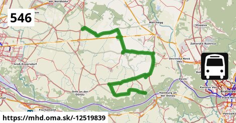
Zastávky na linke
Obersiebenbrunn Marktplatz po 4 m ¤,
Untersiebenbrunn Kirchengasse po 3,2 km ¤,
Untersiebenbrunn Kellergasse po 3,4 km ¤,
Schönfeld im Marchfeld Hauptstraße po 8,4 km ¤,
Schönfeld-Lassee Bahnhof po 10,8 km ¤,
Lassee Wagramstraße po 12,1 km ¤,
Lassee Mittelschule po 13,3 km ¤,
Lassee Kirche po 14,1 km ¤,
Lassee Pointengasse po 14,5 km ¤,
Lassee Hagelweg po 16 km ¤,
Lassee Erholungszentrum po 18 km ¤,
Groißenbrunn Schloßhofer Straße po 22 km ¤,
Engelhartstetten Volksschule po 26 km ¤,
Engelhartstetten Siedlung po 27 km ¤,
Loimersdorf Lasseer Straße po 30 km ¤,
Loimersdorf Kirche po 30 km ¤,
Kopfstetten Feuerwehr po 33 km ¤,
Pframa Ortsmitte po 36 km ¤,
Eckartsau Marktplatz po 38 km ¤,
Eckartsau Kornfeldweg po 39 km ¤,
Witzelsdorf Ortsmitte po 42 km ¤,
Stopfenreuth Kirche po 46 km ¤Zastávky popri linke:, 1 z 2
Obersiebenbrunn Marktplatz po ¤,
Obersiebenbrunn Marktplatz po 4 m ¤,
Obersiebenbrunn Graf-Kollonitsch-Straße po 413 m ¤,
Obersiebenbrunn Graf-Kollonitsch-Straße po 473 m ¤,
Untersiebenbrunn Kirchengasse po 3,1 km ¤,
Untersiebenbrunn Kirchengasse po 3,2 km ¤,
Untersiebenbrunn Kellergasse po 3,4 km ¤,
Untersiebenbrunn Kellergasse po 3,4 km ¤,
Schönfeld im Marchfeld Hauptstraße po 8,4 km ¤,
Schönfeld-Lassee Bahnhof po 10,8 km ¤,
Lassee Wagramstraße po 12,1 km ¤,
Lassee Mittelschule po 13,3 km ¤,
Lassee Mittelschule po 13,3 km ¤,
Lassee Kirche po 14,1 km ¤,
Lassee Pointengasse po 14,5 km ¤,
Lassee Pointengasse po 14,5 km ¤,
Lassee Kirche po 15 km ¤,
Lassee Hagelweg po 16 km ¤,
Lassee Hagelweg po 16 km ¤,
Lassee Erholungszentrum po 18 km ¤,
Lassee Erholungszentrum po 18 km ¤,
Groißenbrunn Schloßhofer Straße po 22 km ¤Zastávky popri linke:, 2 z 2
Groißenbrunn Schloßhofer Straße po 22 km ¤,
Engelhartstetten Kirche po 26 km ¤,
Engelhartstetten Volksschule po 26 km ¤,
Engelhartstetten Volksschule po 26 km ¤,
Engelhartstetten Siedlung po 27 km ¤,
Engelhartstetten Gemeindeamt po 27 km ¤,
Engelhartstetten Gemeindeamt po 27 km ¤,
Loimersdorf Lasseer Straße po 30 km ¤,
Loimersdorf Lasseer Straße po 30 km ¤,
Loimersdorf Kirche po 30 km ¤,
Loimersdorf Kirche po 30 km ¤,
Kopfstetten Feuerwehr po 33 km ¤,
Kopfstetten Feuerwehr po 33 km ¤,
Pframa Ortsmitte po 36 km ¤,
Pframa Ortsmitte po 36 km ¤,
Eckartsau Marktplatz po 38 km ¤,
Eckartsau Kornfeldweg po 39 km ¤,
Eckartsau Kornfeldweg po 39 km ¤,
Witzelsdorf Ortsmitte po 42 km ¤,
Witzelsdorf Ortsmitte po 42 km ¤,
Stopfenreuth Kirche po 46 km ¤Má spoločné úseky s linkami:
Bus 545: Orth an der Donau = > Gänserndorf po 232 m ¤ ,
Bus 545: Gänserndorf = > Orth an der Donau po 232 m ¤ ,
Bus 545: Gänserndorf = > Haringsee po 232 m ¤ ,
Bus 545: Leopoldsdorf im Marchfeld = > Untersiebenbrunn po 232 m ¤ ,
Bus 545: Gänserndorf = > Orth an der Donau Biotech Campus = > Orth an der Donau po 232 m ¤ ,
Bus 545: Haringsee = > Gänserndorf po 232 m ¤ ,
Bus 540: Schloßhof = > Obersiebenbrunn Marktplatz po 9,6 km ¤ ,
Bus 540: Schloßhof = > Wien Aspern Nord po 9,6 km ¤ ,
Bus 546: Lassee = > Schönfeld po 9,6 km ¤ ,
Bus 541: Schönfeld-Lassee = > Siebenbrunn-Leopoldsdorf po 11,0 km ¤ ,
Bus 541: Siebenbrunn-Leopoldsdorf = > Schönfeld-Lassee po 12,0 km ¤ ,
Bus 541: Siebenbrunn-Leopoldsdorf = > Schönfeld im Marchfeld Hauptstraße po 12,0 km ¤ ,
Bus 541: Straudorf Kirche = > Schönfeld-Lassee po 12,0 km ¤ ,
Bus 546: Schönfeld im Marchfeld Hauptstraße = > Engelhartstetten Volksschule po 19 km ¤ ,
Bus 540: Wien Hausfeldstraße = > Schloßhof po 22 km ¤ ,
Bus 546: Markthof = > Stopfenreuth po 23 km ¤ ,
Bus 546: Engelhartstetten Volksschule = > Stopfenreuth po 27 km ¤ ,
Bus 546: Stopfenreuth = > Loimersdorf Kirche = > Markthof po 27 km ¤ ,
Bus 546: Stopfenreuth = > Engelhartstetten Volksschule po 30 km ¤ ,
Bus 550: Engelhartstetten Kirche = > Wien Aspernstraße po 31 km ¤ ,
Bus 550: Hainburg an der Donau Landesklinikum = > Wien Aspernstraße po 31 km ¤ ,
Bus 550: Engelhartstetten Volksschule = > Großenzersdorf Stadtmauer po 31 km ¤ ,
Bus 550: Wien Aspernstraße = > Hainburg an der Donau Landesklinikum po 31 km ¤ ,
Bus 552: Groß-Enzersdorf Busbahnhof = > Stopfenreuth Uferstraße po 36 km ¤ ,
Bus 552: Groß-Enzersdorf Stadtmauer = > Stopfenreuth Uferstraße po 36 km ¤ ,
Bus 546: Stopfenreuth = > Gänserndorf po 36 km ¤ ,
Bus 546: Gänserndorf = > Stopfenreuth po 36 km ¤ ,
Bus 546: Gänserndorf = > Markthof = > Stopfenreuth po 36 km ¤ ,
Bus 550: Orth an der Donau Schlossplatz = > Engelhartstetten Volksschule po 38 km ¤ ,
Bus 552: Stopfenreuth Uferstraße = > Großenzersdorf Busbahnhof po 41 km ¤ ,
Bus 552: Stopfenreuth Uferstraße = > Orth an der Donau Biotech Campus = > Groß-Enzersdorf Busbahnhof po 41 km ¤ ,
Bus 552: Stopfenreuth Uferstraße = > Wien Aspernstraße po 41 km ¤ ,
Bus 552: Stopfenreuth Uferstraße = > Großenzersdorf Stadtmauer po 41 km ¤ ,
Bus 546: Stopfenreuth = > Markthof po 45 km ¤ Trasa vedie cez obce
Lassee: 12,8 km (28 %),
Engelhartstetten: 12,5 km (27.4 %),
Eckartsau: 12,0 km (26.4 %),
Gemeinde Untersiebenbrunn: 4,8 km (10.4 %),
Gemeinde Obersiebenbrunn: 1,62 km (3.6 %),
Podobné linky 546:
ine: Bus 546: Stopfenreuth = > Gänserndorf, ,
ine: Bus 546: Schönfeld im Marchfeld Hauptstraße = > Engelhartstetten Volksschule, ,
ine: Bus 546: Engelhartstetten Volksschule = > Stopfenreuth, ,
ine: Bus 546: Stopfenreuth = > Loimersdorf Kirche = > Markthof, ,
ine: Bus 546: Lassee = > Schönfeld, ,
ine: Bus 546: Stopfenreuth = > Engelhartstetten Volksschule, ,
ine: Bus 546: Gänserndorf = > Markthof = > Stopfenreuth, ,
ine: Bus 546: Stopfenreuth = > Markthof, ,
ine: Bus 546: Markthof = > Stopfenreuth, ,
ine: Bus 546: Gänserndorf = > Stopfenreuth,
Viac info:
aktualizovať mapu,
uprav v JOSM (pokročilé),
-12519839,
stiahni GPX, route: bus, to: Stopfenreuth Kirche, from: Obersiebenbrunn Marktplatz, network: VOR, route name: Bus 546: Obersiebenbrunn Marktplatz => Stopfenreuth, osm version: 31, osm changeset: 0, osm timestamp: 2026 03 17T12:49:34Z, Q2516485, 2, dlzka: 45648, pocet seg: 1, lon: 16.8262, lat: 48.2046, povodna farba: dr. richard no blaguss,
Zdroj dát
Mapové údaje pochádzajú z
www.OpenStreetMap.org, databáza je prístupná pod licenciou
ODbL.

Mapový podklad vytvára a aktualizuje
Freemap Slovakia (www.freemap.sk), šíriteľný pod licenciou CC-BY-SA. Fotky sme čerpali z galérie portálu freemap.sk, autori fotiek sú uvedení pri jednotlivých fotkách a sú šíriteľné pod licenciou CC a z wikipédie. Výškový profil trás čerpáme z
SRTM. Niečo vám chýba?
Pridajte to. Sme radi, že tvoríte slobodnú wiki mapu sveta.