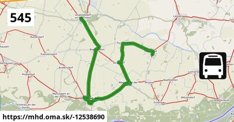
Zastávky na linke
Leopoldsdorf im Marchfeld Rathausplatz po 3 m ¤, Leopoldsdorf im Marchfeld Breitstetter Straße po 595 m ¤, Breitstetten Leopoldsdorfer Straße po 3,1 km ¤, Breitstetten Kirche po 3,7 km ¤, Orth/Donau Wiener Straße 16/29 po 9,0 km ¤, Orth an der Donau Schlossplatz po 9,7 km ¤, Orth an der Donau Gemeindeamt po 10,0 km ¤, Orth/Donau Hauptstraße 75 po 11,1 km ¤, Wagram/Donau Ortsmitte po 14,9 km ¤, Straudorf Kirche po 18 km ¤, Fuchsenbigl Kapelle po 19 km ¤, Haringsee Friedhofweg po 22 km ¤, Haringsee Hauptstraße/Steingasse po 23 km ¤, Haringsee Volksschule po 23 km ¤, Haringsee Pframastraße po 24 km ¤Zastávky popri linke:, 1 z 2
Leopoldsdorf im Marchfeld Rathausplatz po 3 m ¤, Renate Cvrkal po 68 m ¤, Leopoldsdorf im Marchfeld Breitstetter Straße po 584 m ¤, Leopoldsdorf im Marchfeld Breitstetter Straße po 595 m ¤, Breitstetten Leopoldsdorfer Straße po 3,1 km ¤, Breitstetten Leopoldsdorfer Straße po 3,1 km ¤, Breitstetten Kirche po 3,7 km ¤, Breitstetten Kirche po 3,7 km ¤, Breitstetten Am Anger po 3,9 km ¤, Orth/Donau Wiener Straße 16/29 po 9,0 km ¤, Orth/Donau Wiener Straße 16/29 po 9,0 km ¤, Orth an der Donau Schlossplatz po 9,7 km ¤, Orth an der Donau Schlossplatz po 9,7 km ¤, Orth an der Donau Gemeindeamt po 10,0 km ¤, Orth an der Donau Gemeindeamt po 10,0 km ¤, Orth/Donau Hauptstraße 45 po 10,7 km ¤Zastávky popri linke:, 2 z 2
Orth/Donau Hauptstraße 75 po 11,1 km ¤, Wagram/Donau Ortsmitte po 14,8 km ¤, Wagram/Donau Ortsmitte po 14,9 km ¤, Straudorf Kirche po 18 km ¤, Straudorf Kirche po 18 km ¤, Fuchsenbigl Kapelle po 19 km ¤, Fuchsenbigl Kapelle po 19 km ¤, Haringsee Friedhofweg po 22 km ¤, Haringsee Friedhofweg po 22 km ¤, Haringsee Hauptstraße/Steingasse po 23 km ¤, Haringsee Hauptstraße/Steingasse po 23 km ¤, Haringsee Volksschule po 23 km ¤, Haringsee Volksschule po 23 km ¤, Haringsee Pframastraße po 24 km ¤, Haringsee Pframastraße po 24 km ¤prestupné linky:
Bus 554: Leopoldsdorf im Marchfeld Rathausplatz = > Deutsch-Wagram Bahnhof po 20 m ¤, Bus 554: Leopoldsdorf im Marchfeld Rathausplatz = > Großhofen Landesstraße po 52 m ¤Má spoločné úseky s linkami:
Bus 541: Schönfeld-Lassee = > Siebenbrunn-Leopoldsdorf po 140 m ¤ , Bus 554: Orth an der Donau Schlossplatz = > Deutsch-Wagram Bahnhof po 2,6 km ¤ , Bus 554: Orth an der Donau Gemeindeamt = > Deutsch-Wagram Bahnhof po 2,6 km ¤ , Bus 545: Orth an der Donau = > Gänserndorf po 2,9 km ¤ , Bus 545: Gänserndorf = > Orth an der Donau Biotech Campus = > Orth an der Donau po 3,7 km ¤ , Bus 545: Haringsee = > Gänserndorf po 3,7 km ¤ , Bus 545: Obersiebenbrunn = > Orth an der Donau po 3,7 km ¤ , Bus 545: Gänserndorf = > Orth an der Donau po 3,7 km ¤ , Bus 554: Großhofen Landesstraße = > Orth/Donau Gemeindeamt po 7,8 km ¤ , Bus 554: Deutsch-Wagram Bahnhof = > Orth an der Donau Schlossplatz po 7,8 km ¤ , Bus 545: Gänserndorf = > Haringsee po 7,8 km ¤ , Bus 553: Orth an der Donau Gemeindeamt = > Großenzersdorf Busbahnhof po 9,0 km ¤ , Bus 550: Wien Aspernstraße = > Orth an der Donau Gemeindeamt po 9,0 km ¤ , Bus 550: Orth an der Donau Gemeindeamt = > Wien Aspernstraße po 9,0 km ¤ , Bus 553: Orth an der Donau Gemeindeamt = > Mühlleiten Hubertusstraße = > Großenzersdorf Stadtmauer po 9,0 km ¤ , Bus 552: Groß-Enzersdorf Stadtmauer = > Orth an der Donau Gemeindeamt po 9,0 km ¤ , Bus 553: Orth an der Donau Gemeindeamt = > Mühlleiten Hubertusstraße = > Großenzersdorf Busbahnhof po 9,0 km ¤ , Bus 553: Großenzersdorf Busbahnhof = > Mühlleiten Hubertusstraße = > Orth an der Donau Gemeindeamt po 9,0 km ¤ , Bus 552: Orth an der Donau Gemeindeamt = > Großenzersdorf Busbahnhof po 9,0 km ¤ , Bus 552: Groß-Enzersdorf Busbahnhof = > Orth an der Donau Gemeindeamt po 9,0 km ¤ , Bus 553: Großenzersdorf Busbahnhof = > Orth an der Donau Gemeindeamt po 9,0 km ¤ , Bus 550: Wien Aspernstraße = > Orth an der Donau Biotech Campus = > Orth an der Donau Gemeindeamt po 9,0 km ¤ , Bus 545: Orth/Donau Wiener Straße = > Haringsee po 9,6 km ¤ , Bus 550: Engelhartstetten Kirche = > Wien Aspernstraße po 11,1 km ¤ , Bus 552: Groß-Enzersdorf Stadtmauer = > Stopfenreuth Uferstraße po 11,1 km ¤ , Bus 552: Stopfenreuth Uferstraße = > Großenzersdorf Stadtmauer po 11,1 km ¤ , Bus 550: Engelhartstetten Volksschule = > Großenzersdorf Stadtmauer po 11,1 km ¤ , Bus 552: Stopfenreuth Uferstraße = > Wien Aspernstraße po 11,1 km ¤ , Bus 552: Stopfenreuth Uferstraße = > Orth an der Donau Biotech Campus = > Groß-Enzersdorf Busbahnhof po 11,1 km ¤ , Bus 552: Groß-Enzersdorf Busbahnhof = > Stopfenreuth Uferstraße po 11,1 km ¤ , Bus 552: Stopfenreuth Uferstraße = > Großenzersdorf Busbahnhof po 11,1 km ¤ , Bus 550: Hainburg an der Donau Landesklinikum = > Wien Aspernstraße po 11,1 km ¤ , Bus 550: Wien Aspernstraße = > Hainburg an der Donau Landesklinikum po 11,1 km ¤ , Bus 550: Orth an der Donau Schlossplatz = > Engelhartstetten Volksschule po 11,5 km ¤ , Bus 545: Haringsee = > Orth an der Donau po 11,5 km ¤ , Bus 541: Straudorf Kirche = > Schönfeld-Lassee po 21 km ¤ , Bus 541: Siebenbrunn-Leopoldsdorf = > Schönfeld-Lassee po 21 km ¤ , Bus 541: Siebenbrunn-Leopoldsdorf = > Schönfeld im Marchfeld Hauptstraße po 21 km ¤ , Bus 541: Haringsee Pframastraße = > Siebenbrunn-Leopoldsdorf po 21 km ¤Trasa vedie cez obce
Gemeinde Orth an der Donau: 8,2 km (34.7 %), Haringsee: 7,3 km (31.2 %), Gemeinde Leopoldsdorf im Marchfelde: 5,5 km (23.2 %), Eckartsau: 2,5 km (10.8 %),
Podobné linky 545:
ine: Bus 545: Obersiebenbrunn = > Orth an der Donau, , ine: Bus 545: Leopoldsdorf im Marchfeld = > Untersiebenbrunn, , ine: Bus 545: Gänserndorf = > Haringsee, , ine: Bus 545: Haringsee = > Orth an der Donau, , ine: Bus 545: Gänserndorf = > Orth an der Donau Biotech Campus = > Orth an der Donau, , ine: Bus 545: Orth/Donau Wiener Straße = > Haringsee, , ine: Bus 545, , ine: Bus 545: Gänserndorf = > Orth an der Donau, , ine: Bus 545: Haringsee = > Gänserndorf, , ine: Bus 545: Pezinok = > Šenkvice = > Budmerice, , ine: Bus 545: Orth an der Donau = > Gänserndorf, , ine: Bus 545: Budmerice = > Šenkvice = > Pezinok,Viac info: aktualizovať mapu, uprav v JOSM (pokročilé), -12538690, stiahni GPX, route: bus, to: Haringsee Pframastraße, from: Leopoldsdorf im Marchfeld Rathausplatz, network: VOR, route name: Bus 545: Leopoldsdorf im Marchfeld => Haringsee, osm version: 15, osm changeset: 0, osm timestamp: 2025 11 25T02:30:30Z, Q2516485, 2, dlzka: 23529, pocet seg: 1, lon: 16.7273, lat: 48.1786, povodna farba: dr. richard no blaguss,