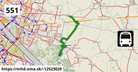
Zastávky na linke
Raasdorf Kirche po ¤,
Raasdorf Bahnhof po 2,1 km ¤,
Großenzersdorf Stadtmauer po 8,5 km ¤,
Groß-Enzersdorf Busbahnhof po 9,0 km ¤,
Groß-Enzersdorf Mittelschule po 9,3 km ¤,
Groß Enzersdorf Volksschule po 10,4 km ¤,
Groß-Enzersdorf Fliedergasse po 11,1 km ¤,
Groß-Enzersdorf Auvorstadt po 12,4 km ¤,
Groß-Enzersdorf Napoleongasse po 12,8 km ¤,
Groß-Enzersdorf Fliedergasse po 13,3 km ¤,
Groß Enzersdorf Volksschule po 14,0 km ¤Zastávky popri linke:
Raasdorf Kirche po ¤,
Raasdorf Kirche po 4 m ¤,
Raasdorf Bahnhof po 2,1 km ¤,
Großenzersdorf Stadtmauer po 8,4 km ¤,
Großenzersdorf Stadtmauer po 8,5 km ¤,
Groß-Enzersdorf Busbahnhof po 9,0 km ¤,
Groß-Enzersdorf Busbahnhof po 9,0 km ¤,
Groß-Enzersdorf Busbahnhof po 9,0 km ¤,
Groß-Enzersdorf po 9,0 km ¤,
Groß-Enzersdorf Busbahnhof po 9,0 km ¤,
Groß-Enzersdorf Mittelschule po 9,3 km ¤,
Groß-Enzersdorf Mittelschule po 9,3 km ¤,
Groß Enzersdorf Volksschule po 10,4 km ¤,
Groß-Enzersdorf Fliedergasse po 11,1 km ¤,
Groß-Enzersdorf Auvorstadt po 12,4 km ¤,
Groß-Enzersdorf Napoleongasse po 12,8 km ¤,
Groß-Enzersdorf Fliedergasse po 13,3 km ¤,
Trafik Krekner po 13,4 km ¤,
Groß Enzersdorf Volksschule po 14,0 km ¤Má spoločné úseky s linkami:
Bus 540: Schloßhof = > Wien Hausfeldstraße po 155 m ¤ ,
Bus 540: Wien Hausfeldstraße = > Schloßhof po 155 m ¤ ,
Bus 540: Obersiebenbrunn Marktplatz = > Wien Hausfeldstraße po 155 m ¤ ,
Bus 551: Gänserndorf = > Groß-Enzersdorf po 1,37 km ¤ ,
Bus 551: Groß Enzersdorf Volksschule = > Gänserndorf Busbahnhof po 1,37 km ¤ ,
Bus 551: Groß-Enzersdorf Auvorstadt = > Gänserndorf Busbahnhof po 1,37 km ¤ ,
Bus 550: Wien Aspernstraße = > Orth an der Donau Biotech Campus = > Orth an der Donau Gemeindeamt po 8,0 km ¤ ,
Bus 552: Stopfenreuth Uferstraße = > Wien Aspernstraße po 8,0 km ¤ ,
Bus 550: Wien Aspernstraße = > Orth an der Donau Gemeindeamt po 8,0 km ¤ ,
Bus 550: Engelhartstetten Kirche = > Wien Aspernstraße po 8,0 km ¤ ,
Bus 550: Orth an der Donau Gemeindeamt = > Wien Aspernstraße po 8,0 km ¤ ,
Bus 550: Hainburg an der Donau Landesklinikum = > Wien Aspernstraße po 8,0 km ¤ ,
Bus 550: Wien Aspernstraße = > Hainburg an der Donau Landesklinikum po 8,0 km ¤ ,
Bus 26A: Kagran = > Groß-Enzersdorf po 8,0 km ¤ ,
Bus 26A: Groß-Enzersdorf = > Kagran po 8,0 km ¤ ,
Bus 552: Groß-Enzersdorf Stadtmauer = > Orth an der Donau Gemeindeamt po 8,9 km ¤ ,
Bus 550: Engelhartstetten Volksschule = > Großenzersdorf Stadtmauer po 8,9 km ¤ ,
Bus 552: Groß-Enzersdorf Stadtmauer = > Stopfenreuth Uferstraße po 8,9 km ¤ ,
Bus 552: Stopfenreuth Uferstraße = > Großenzersdorf Stadtmauer po 9,0 km ¤ ,
Bus 553: Orth an der Donau Gemeindeamt = > Mühlleiten Hubertusstraße = > Großenzersdorf Stadtmauer po 9,0 km ¤ ,
Bus 553: Großenzersdorf Busbahnhof = > Mühlleiten Hubertusstraße = > Orth an der Donau Gemeindeamt po 9,9 km ¤ ,
Bus 553: Orth an der Donau Gemeindeamt = > Großenzersdorf Busbahnhof po 9,9 km ¤ ,
Bus 552: Orth an der Donau Gemeindeamt = > Großenzersdorf Busbahnhof po 9,9 km ¤ ,
Bus 552: Groß-Enzersdorf Busbahnhof = > Orth an der Donau Gemeindeamt po 9,9 km ¤ ,
Bus 552: Stopfenreuth Uferstraße = > Orth an der Donau Biotech Campus = > Groß-Enzersdorf Busbahnhof po 9,9 km ¤ ,
Bus 552: Groß-Enzersdorf Busbahnhof = > Stopfenreuth Uferstraße po 9,9 km ¤ ,
Bus 553: Großenzersdorf Busbahnhof = > Orth an der Donau Gemeindeamt po 9,9 km ¤ ,
Bus 553: Orth an der Donau Gemeindeamt = > Mühlleiten Hubertusstraße = > Großenzersdorf Busbahnhof po 9,9 km ¤ ,
Bus 552: Stopfenreuth Uferstraße = > Großenzersdorf Busbahnhof po 9,9 km ¤ ,
Bus 551: Groß-Enzersdorf Busbahnhof = > Groß-Enzersdorf Auvorstadt = > Groß-Enzersdorf Busbahnhof po 12,2 km ¤ ,
Bus 551: Groß-Enzersdorf Busbahnhof = > Groß-Enzersdorf Auvorstadt = > Groß-Enzersdorf Stadtmauer po 12,2 km ¤ Podobné linky 551:
ine: Bus 551: Groß-Enzersdorf Busbahnhof = > Groß-Enzersdorf Auvorstadt = > Groß-Enzersdorf Busbahnhof, ,
ine: Bus 551: Groß-Enzersdorf Busbahnhof = > Groß-Enzersdorf Auvorstadt = > Groß-Enzersdorf Stadtmauer, ,
ine: Bus 551: Groß Enzersdorf Volksschule = > Gänserndorf Busbahnhof, ,
ine: Bus 551: Groß-Enzersdorf Auvorstadt = > Gänserndorf Busbahnhof, ,
ine: Bus 551: Orlová, Lutyně, aut. nádr. = > Ostrava,Hranečník, ,
ine: Bus 551: Gänserndorf = > Groß-Enzersdorf, ,
ine: Bus 551, ,
ine: Bus 551: Ostrava,Hranečník = > Orlová Lutyně,aut. nádr.,
Viac info:
aktualizovať mapu,
uprav v JOSM (pokročilé),
-12523029,
stiahni GPX, route: bus, to: Groß Enzersdorf Busbahnhof, via: Groß Enzersdorf Auvorstadt, from: Raasdorf Kirche, network: VOR, route name: Bus 551: Raasdorf Kirche => Groß Enzersdorf Auvorstadt => Groß Enzersdorf Busbahnhof, osm version: 14, osm changeset: 0, osm timestamp: 2025 12 02T03:53:20Z, Q2516485, 2, dlzka: 14557, pocet seg: 1, lon: 16.5589, lat: 48.2130, povodna farba: dr. richard no,
Zdroj dát
Mapové údaje pochádzajú z
www.OpenStreetMap.org, databáza je prístupná pod licenciou
ODbL.

Mapový podklad vytvára a aktualizuje
Freemap Slovakia (www.freemap.sk), šíriteľný pod licenciou CC-BY-SA. Fotky sme čerpali z galérie portálu freemap.sk, autori fotiek sú uvedení pri jednotlivých fotkách a sú šíriteľné pod licenciou CC a z wikipédie. Výškový profil trás čerpáme z
SRTM. Niečo vám chýba?
Pridajte to. Sme radi, že tvoríte slobodnú wiki mapu sveta.