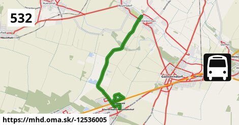
Zastávky popri linke:
Schönkirchen Tannengasse po ¤,
Silberwald Bahnhof po 647 m ¤,
Schönkirchen Waldgasse po 1,59 km ¤,
Schönkirchen Mozartgasse po 1,84 km ¤,
Schönkirchen Haselnussgasse po 2,5 km ¤,
Silberwald Bahnhof po 2,7 km ¤,
Schönkirchen Volksschule po 7,8 km ¤prestupné linky:
Bus 531: Gänserndorf Bahnhof = > Wolkersdorf Mittelschule po 7,7 km ¤,
Bus 531: Gänserndorf Bahnhof = > Wolkersdorf Bahnhof po 7,7 km ¤,
Bus 531: Gänserndorf Bahnhof = > Auersthal Schulen po 7,7 km ¤,
Bus 531: Gänserndorf Busbahnhof = > Auersthal Schulen po 7,7 km ¤,
Bus 531: Wolkersdorf Gymnasium = > Auersthal Europa-Siedlung = > Gänserndorf Bahnhof po 7,7 km ¤,
Bus 531: Wolkersdorf Gymnasium = > Gänserndorf Bahnhof po 7,7 km ¤,
Bus 531: Auersthal Schulen = > Gänserndorf Bahnhof po 7,7 km ¤,
Bus 535: Gänserndorf Bahnhof = > Mistelbach Bahnhof po 7,7 km ¤,
Bus 536: Gänserndorf Bahnhof = > Spannberg Hauptplatz po 7,7 km ¤,
Bus 536: Gänserndorf Bahnhof = > Dürnkrut Bahnhof po 7,7 km ¤,
Bus 536: Spannberg Hauptplatz = > Gänserndorf Busbahnhof po 7,7 km ¤,
Bus 536: Dürnkrut Bahnhof = > Gänserndorf Busbahnhof po 7,7 km ¤,
Bus 535: Gänserndorf Bahnhof = > Mistelbach Bahnhof po 7,7 km ¤,
Bus 535: Mistelbach Bahnhof = > Gänserndorf Bahnhof po 7,7 km ¤,
Bus 105: St. Pölten Landhaus Nord = > Gänserndorf Bahnhof po 7,7 km ¤,
Bus 105: Gänserndorf Bahnhof = > St. Pölten Hauptbahnhof Nord po 7,7 km ¤Má spoločné úseky s linkami:
Bus 532: Strasshof Lehárgasse = > Matzen Schule po 1,07 km ¤ ,
Bus 532: Schönkirchen Volksschule = > Reyersdorf Hauptstraße = > Strasshof Lehargasse po 1,07 km ¤ ,
Bus 523: Albert-Sever-Straße = > Schulcampus po 2,7 km ¤ ,
Bus 523: Schulcampus = > Silberwald po 2,7 km ¤ ,
Bus 532: Schönkirchen Volksschule = > Schönkirchen Tannengasse po 4,6 km ¤ ,
Bus 532: Schönkirchen Volksschule = > Reyersdorf Hauptstraße = > Schönkirchen Tannengasse po 4,6 km ¤ ,
Bus 532: Matzen Schule = > Strasshof Lehargasse po 6,1 km ¤ ,
Bus 532: Matzen Schule = > Auersthal Schulen = > Strasshof Lehargasse po 6,1 km ¤ ,
Bus 531: Auersthal Schulen = > Schönkirchen Volksschule = > Gänserndorf Bahnhof po 7,8 km ¤ Podobné linky 532:
ine: Bus 532: Strasshof Lehárgasse = > Matzen Schule, ,
ine: Bus 532: Schönkirchen Volksschule = > Reyersdorf Hauptstraße = > Strasshof Lehargasse, ,
ine: Bus 532: Schönkirchen Volksschule = > Schönkirchen Tannengasse, ,
ine: Bus 532: Schönkirchen Volksschule = > Reyersdorf Hauptstraße = > Schönkirchen Tannengasse, ,
ine: Bus 532: Matzen Schule = > Strasshof Lehargasse, ,
ine: Bus 532: Matzen Schule = > Auersthal Schulen = > Strasshof Lehargasse,
Viac info:
aktualizovať mapu,
uprav v JOSM (pokročilé),
-12536005,
stiahni GPX, route: bus, to: Schönkirchen Volksschule, from: Schönkirchen Tannengasse, network: VOR, route name: Bus 532: Schönkirchen Tannengasse => Schönkirchen Volksschule, osm version: 11, osm changeset: 0, osm timestamp: 2026 06 02T09:05:29Z, Q2516485, de:Verkehrsverbund Ost Region, 2, dlzka: 7844, pocet seg: 1, lon: 16.6808, lat: 48.3420, povodna farba: dr. richard no,
Zdroj dát
Mapové údaje pochádzajú z
www.OpenStreetMap.org, databáza je prístupná pod licenciou
ODbL.

Mapový podklad vytvára a aktualizuje
Freemap Slovakia (www.freemap.sk), šíriteľný pod licenciou CC-BY-SA. Fotky sme čerpali z galérie portálu freemap.sk, autori fotiek sú uvedení pri jednotlivých fotkách a sú šíriteľné pod licenciou CC a z wikipédie. Výškový profil trás čerpáme z
SRTM. Niečo vám chýba?
Pridajte to. Sme radi, že tvoríte slobodnú wiki mapu sveta.