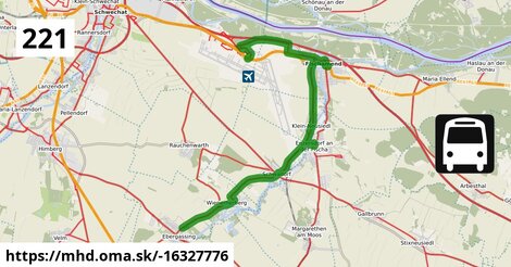
Zastávky na linke
Flughafen Wien Busterminal po ¤, Fischamend Zeppelinstraße po 3,8 km ¤, Fischamend Wiener Straße po 5,3 km ¤, Fischamend Fischaturm po 5,8 km ¤, Fischamend Bahnhof po 6,3 km ¤, Fischamend Fischaturm po 6,9 km ¤, Fischamend Kleinneusiedler Straße po 7,3 km ¤, Fischamend Kirchenweg po 7,5 km ¤, Kleinneusiedl Fischamender Straße po 9,6 km ¤, Kleinneusiedl Schwadorfer Straße 18 po 10,0 km ¤, Enzersdorf an der Fischa Volksschule po 11,2 km ¤, Schwadorf Volksschule po 13,2 km ¤, Schwadorf Fischamender Straße po 13,6 km ¤, Schwadorf Schulgasse po 13,9 km ¤, Wienerherberg Kleinfeldgasse po 17 km ¤, Wienerherberg Seegasse po 17 km ¤, Wienerherberg Fabriksgasse po 17 km ¤Zastávky popri linke:, 1 z 2
Flughafen Wien Busterminal po ¤, Flughafen Wien Busterminal po 19 m ¤, Flughafen Wien Busterminal po 38 m ¤, automat na lístky po 39 m ¤, automat na lístky po 42 m ¤, automat na lístky po 48 m ¤, Fischamend Zeppelinstraße po 3,8 km ¤, Fischamend Zeppelinstraße po 3,8 km ¤, Fischamend Wiener Straße po 5,3 km ¤, Fischamend Wiener Straße po 5,3 km ¤, Fischamend Fischaturm po 5,8 km ¤, automat na lístky po 6,3 km ¤, Fischamend Bahnhof po 6,3 km ¤, Fischamend Fischaturm po 6,9 km ¤, Fischamend Kleinneusiedler Straße po 7,3 km ¤, Fischamend Kirchenweg po 7,5 km ¤, Fischamend Kirchenweg po 7,6 km ¤, Kleinneusiedl Fischamender Straße po 9,6 km ¤Zastávky popri linke:, 2 z 2
Kleinneusiedl Fischamender Straße po 9,7 km ¤, Kleinneusiedl Kirche po 9,8 km ¤, Kleinneusiedl Schwadorfer Straße 18 po 10,0 km ¤, Kleinneusiedl Enzersdorfer Weg po 10,1 km ¤, Enzersdorf an der Fischa Dreifaltigkeitsplatz po 11,1 km ¤, Enzersdorf an der Fischa Dreifaltigkeitsplatz po 11,1 km ¤, Enzersdorf an der Fischa Volksschule po 11,2 km ¤, Schwadorf Volksschule po 13,2 km ¤, Schwadorf Volksschule po 13,2 km ¤, Schwadorf Fischamender Straße po 13,6 km ¤, Schwadorf Schulgasse po 13,9 km ¤, Schwadorf Schulgasse po 13,9 km ¤, Wienerherberg Kleinfeldgasse po 17 km ¤, Wienerherberg Kleinfeldgasse po 17 km ¤, Wienerherberg Seegasse po 17 km ¤, Wienerherberg Seegasse po 17 km ¤, Wienerherberg Fabriksgasse po 17 km ¤, Wienerherberg Fabriksgasse po 17 km ¤prestupné linky:
Flixbus N66: Hamburg ZOB = > Wien, Flughafen Schwechat po ¤, Flixbus 919: Wrocław, dworzec autobusowy = > Wien, Flughafen Schwechat po ¤, Bus airport shuttle: Mazur Parkplatz = > Flughafen Wien Busterminal po 36 m ¤, S7: Mistelbach = > Wolfsthal po 7,5 km ¤, REX7: Wien Floridsdorf = > Wolfsthal po 7,5 km ¤, REX7: Wolfsthal = > Wien Floridsdorf po 7,5 km ¤, S7: Wolfsthal = > Mistelbach po 7,5 km ¤, Bus 248: Gramatneusiedl Bahnhof = > Reisenberg Hermannstadtstraße = > Enzersdorf an der Fischa Volksschule po 11,2 km ¤, Bus 272: Wien Simmering = > Schwechat Am Concorde-Business-Park = > Schwadorf Schiefer Weg = > Bruck an der Leitha Neue Mittelschule po 13,6 km ¤, Bus 272: Bruck an der Leitha Neue Mittelschule = > Schwadorf Schiefer Weg = > Wien Simmering po 13,6 km ¤, Bus 272: Wien Simmering = > Schwadorf Schiefer Weg = > Bruck an der Leitha Neue Mittelschule po 13,6 km ¤, Bus 272: Bruck an der Leitha Neue Mittelschule = > Schwechat Bahnhof = > Wien Simmering po 13,6 km ¤, Bus 272: Wien Simmering = > Schwechat Am Concorde-Business-Park = > Schwadorf Schiefer Weg = > Bruck an der Leitha Gymnasium/HAK po 13,6 km ¤Má spoločné úseky s linkami:
Flixbus 1291: Viedeň Erdberg, autobusová stanica VIB = > Krakov, autobusová stanica MDA po 319 m ¤ , Bus VAB1: Flughafen Wien = > Westbahnhof po 319 m ¤ , Bus VAB3: Flughafen Wien = > Donauzentrum po 319 m ¤ , Bus 102806: Bratislava, Autobusová stanica - > Wien Hauptbahnhof po 319 m ¤ , Bus RegioJet: Bratislava, Autobusová stanica - > Wien Hauptbahnhof po 319 m ¤ , Bus RegioJet: Wien Hauptbahnhof - > Bratislava, Autobusová stanica po 319 m ¤ , Bus 102806: Wien Hauptbahnhof - > Bratislava, Autobusová stanica po 319 m ¤ , Bus VAB2: Flughafen Wien = > Schwedenplatz/Morzinplatz po 319 m ¤ , Bus airport shuttle: Flughafen Wien Busterminal = > Mazur Parkplatz po 319 m ¤ , Flixbus N66: Wien, Flughafen Schwechat = > Hamburg ZOB po 319 m ¤ , Flixbus 919: Wien, Flughafen Schwechat = > Wrocław, dworzec autobusowy po 319 m ¤ , Flixbus 917: Krakov, autobusová stanica MDA = > Ľubľana, autobusová stanica po 319 m ¤ , Flixbus 917: Ľubľana, autobusová stanica = > Krakov, autobusová stanica MDA po 319 m ¤ , Flixbus 902: Wien, Hbf. (International Busterminal) = > Budapest, Repülőtér po 319 m ¤ , Bus 102807: Flughafen Wien Busterminal - > Bratislava, Autobusová stanica po 319 m ¤ , Flixbus 1291: Krakov, autobusová stanica MDA = > Viedeň Erdberg, autobusový terminál VIB po 319 m ¤ , Flixbus 902: Budapest, Repülőtér = > Wien, Hbf. (International Busterminal) po 319 m ¤ , Flixbus 901: Bratislava, letisko = > Viedeň Erdberg, autobusový terminál VIB po 319 m ¤ , Flixbus 901: Viedeň Erdberg, autobusový terminál VIB = > Bratislava, letisko po 319 m ¤ , Flixbus K472 (Blaguss Air Liner): Flughafen Wien, Schwechat = > Wien Erdberg, Busterminal VIB po 319 m ¤ , Flixbus N1291: Medyka Granica = > Viedeň Erdberg, autobusový terminál VIB po 319 m ¤ , Flixbus N1291: Viedeň Erdberg, autobusová stanica VIB = > Medyka Granica po 319 m ¤ , Flixbus 901a: Viedeň, hlavná železničná stanica (International Busterminal) = > Bratislava, Letisko po 319 m ¤ , Flixbus 901a: Bratislava, Letisko = > Flixbus 901a: Bratislava, Letisko = > Viedeň, hlavná železničná stanica (International Busterminal) po 319 m ¤ , Bus 273: Flughafen Wien Busterminal = > Neusiedl am See Pannonia Shopping Park = > Neusiedl am See Schulzentrum po 669 m ¤ , Bus 221: Fischamend Bahnhof = > Flughafen Wien Busterminal po 1,00 km ¤ , Bus 273: Neusiedl am See Schulzentrum = > Neusiedl am See Pannonia Shopping Park = > Flughafen Wien Busterminal po 1,00 km ¤ , Bus 273: Neusiedl am See Schulzentrum = > Flughafen Wien Busterminal po 1,00 km ¤ , Bus 273: Neusiedl am See Hauptplatz = > Neusiedl am See Pannonia Shopping Park = > Fischamend Bahnhof = > Flughafen Wien Busterminal po 1,00 km ¤ , Bus 273: Neusiedl am See Hauptplatz = > Neusiedl am See Pannonia Shopping Park = > Flughafen Wien Busterminal po 1,00 km ¤ , Bus 273: Neusiedl am See Hauptplatz = > Fischamend Bahnhof = > Flughafen Wien Busterminal po 1,00 km ¤ , Bus 273: Neusiedl am See Hauptplatz = > Neusiedl am See Pannonia Shopping Park = > Göttlesbrunn Volksschule = > Flughafen Wien Busterminal po 1,00 km ¤ , Bus 273: Flughafen Wien Busterminal = > Fischamend Bahnhof = > Neusiedl am See Schulzentrum po 1,00 km ¤ , Bus 273: Neusiedl am See Schulzentrum = > Neusiedl am See Pannonia Shopping Park = > Fischamend Bahnhof = > Flughafen Wien Busterminal po 1,00 km ¤ , Bus 273: Flughafen Wien Busterminal = > Fischamend Bahnhof = > Neusiedl am See Pannonia Shopping Park = > Neusiedl am See Schulzentrum po 1,00 km ¤ , Bus 221: Rauchenwarth Kirchenplatz = > Flughafen Wien Busterminal po 1,00 km ¤ , Bus 221: Guntramsdorf Lokalbahn = > Fischamend Bahnhof po 5,4 km ¤ , Bus 221: Fischamend Bahnhof = > Guntramsdorf Lokalbahn po 5,4 km ¤ , Bus 273: Fischamend Wiener Straße = > Bruck an der Leitha Bahnhof po 5,6 km ¤ , Bus 273: Bruck an der Leitha Bahnhof = > Fischamend Wiener Straße po 5,6 km ¤ , Bus 273: Neusiedl am See Schulzentrum = > Neusiedl am See Pannonia Shopping Park = > Fischamend Bahnhof po 6,2 km ¤ , Bus 273: Neusiedl am See Schulzentrum = > Neusiedl am See Pannonia Shopping Park = > Göttlesbrunn Volksschule = > Fischamend Bahnhof po 6,2 km ¤ , Bus 222: Flughafen Wien Busterminal = > Ebreichsdorf Bahnhof po 6,2 km ¤ , Bus 222: Flughafen Wien Busterminal = > Ebreichsdorf Georg-Drasche-Siedlung po 6,2 km ¤ , Bus 273: Fischamend Bahnhof = > Neusiedl am See Schulzentrum po 6,2 km ¤ , Bus 273: Fischamend Bahnhof = > Neusiedl am See Hauptplatz po 6,2 km ¤ , Bus 273: Fischamend Bahnhof = > Neusiedl am See Pannonia Shopping Park = > Neusiedl am See Hauptplatz po 6,2 km ¤ , Bus 273: Fischamend Bahnhof = > Maria Ellend Bahnhof = > Neusiedl am See Schulzentrum po 6,2 km ¤ , Bus 273: Bruck an der Leitha Bahnhof = > Fischamend Bahnhof po 6,2 km ¤ , Bus 273: Neusiedl am See Hauptplatz = > Fischamend Bahnhof po 6,2 km ¤ , Bus 273: Neusiedl am See Hauptplatz = > Neusiedl am See Pannonia Shopping Park = > Fischamend Bahnhof po 6,2 km ¤ , Bus 221: Flughafen Wien Busterminal = > Guntramsdorf Lokalbahn po 6,3 km ¤ , Bus 221: Gramatneusiedl Bahnhof = > Flughafen Wien Busterminal po 7,8 km ¤ , Bus 221: Kleinneusiedl Schwadorfer Straße = > Fischamend Bahnhof po 10,0 km ¤ , Bus 272: Schwadorf Schulgasse = > Kleinneusiedl Fischamender Straße po 10,8 km ¤ , Bus 272: Schwechat Wiener Straße = > Schwechat Am Concorde-Business-Park = > Kleinneusiedl Fischamender Straße po 10,8 km ¤ , Bus 222: Fischamend Bahnhof = > Ebreichsdorf Bahnhof po 10,8 km ¤ , Bus 222: Fischamend Bahnhof = > Gramatneusiedl Bahnhof po 10,8 km ¤ , Bus 222: Fischamend Bahnhof = > Ebreichsdorf Georg-Drasche-Siedlung po 10,8 km ¤ , Bus 222: Ebreichsdorf Georg-Drasche-Siedlung = > Fischamend Bahnhof po 10,8 km ¤ , Bus 222: Fischamend Bahnhof = > Unterwaltersdorf Don Bosco-Gymnasium = > Ebreichsdorf Bahnhof po 10,8 km ¤ , Bus 272: Karlsdorf Bergzeile = > Schwadorf Brucker Straße = > Bruck an der Leitha Gymnasium/HAK po 10,8 km ¤ , Bus 272: Kleinneusiedl Fischamender Straße = > Schwadorf Schiefer Weg = > Wien Simmering po 10,8 km ¤ , Bus 272: Kleinneusiedl Fischamender Straße = > Schwechat Wiener Straße po 10,8 km ¤ , Bus 248: Enzersdorf an der Fischa Volksschule = > Gramatneusiedl Bahnhof po 10,8 km ¤ , Bus 248: Enzersdorf an der Fischa Volksschule = > Margarethen am Moos Leithastraße po 10,8 km ¤ , Bus 221: Fischamend Bahnhof = > Rauchenwarth Kirchenplatz po 11,1 km ¤ , Bus 248: Schwadorf Schulgasse = > Gramatneusiedl Bahnhof po 13,6 km ¤ , Bus 248: Gramatneusiedl Bahnhof = > Schwadorf Schulgasse po 13,6 km ¤ , Bus 272: Schwadorf Volksschule = > Rauchenwarth Kirchenplatz po 13,6 km ¤ , Bus 248: Ebergassing Schulen = > Schwadorf Schulgasse po 13,6 km ¤ , Bus 248: Schwadorf Schulgasse = > Reisenberg Hermannstadtstraße = > Gramatneusiedl Bahnhof po 13,6 km ¤ , Bus 248: Schwadorf Schulgasse = > Reisenberg Hermannstadtstraße = > Ebergassing Schulen po 13,6 km ¤ , Bus 221: Schwadorf Volksschule = > Rauchenwarth Kirchenplatz po 13,6 km ¤ , Bus 248: Gramatneusiedl Bahnhof = > Reisenberg Hermannstadtstraße = > Schwadorf Schulgasse po 13,6 km ¤ , Bus 272: Schwadorf Schulgasse = > Rauchenwarth Kirchenplatz po 14,4 km ¤ , Bus 222: Gramatneusiedl Bahnhof = > Flughafen Wien Busterminal po 16 km ¤ , Bus 221: Gramatneusiedl Bahnhof = > Fischamend Bahnhof po 16 km ¤ , Bus 221: Fischamend Bahnhof = > Gramatneusiedl Bahnhof po 16 km ¤ , Bus 222: Ebreichsdorf Georg-Drasche-Siedlung = > Flughafen Wien Busterminal po 16 km ¤ , Bus 221: Fischamend Bahnhof = > Enzersdorf an der Fischa = > Guntramsdorf Lokalbahn po 16 km ¤ , Bus 222: Ebreichsdorf Georg-Drasche-Siedlung = > Unterwaltersdorf Gymnasium = > Flughafen Wien Busterminal po 16 km ¤ , Bus 227: Wien Oberlaa = > Wienerherberg Kleinfeldgasse po 17 km ¤ , Bus 272: Wien Simmering = > Schwechat Am Concorde-Business-Park = > Bruck an der Leitha Neue Mittelschule po 18 km ¤ , Bus 272: Schwechat Wiener Straße = > Bruck an der Leitha Gymnasium/HAK po 18 km ¤ , Bus 272: Bruck an der Leitha Neue Mittelschule = > Wienerherberg Fabriksgasse = > Schwechat Bahnhof = > Wien Simmering po 18 km ¤ , Bus 272: Bruck an der Leitha Neue Mittelschule = > Wienerherberg Fabriksgasse = > Wien Simmering po 18 km ¤ , Bus 272: Trautmannsdorf an der Leitha Volksschule = > Schwechat Wiener Straße po 18 km ¤ , Bus 272: Bruck an der Leitha Gymnasium/HAK = > Wien Simmering po 18 km ¤ , Bus 221: Rauchenwarth Kirchenplatz = > Schwadorf Schulgasse po 18 km ¤Trasa vedie cez obce
Fischamend: 5,8 km (29.5 %), Gemeinde Schwadorf: 4,0 km (20.7 %), Gemeinde Klein-Neusiedl: 2,2 km (11.5 %), Gemeinde Enzersdorf an der Fischa: 656 m (3.4 %),
Podobné linky 221:
ine: Bus 221: Čadca, aut.st. = > Oščadnica, Vreščovka, , ine: Bus 221, , ine: Bus 221: Schwadorf Volksschule = > Rauchenwarth Kirchenplatz, , ine: Bus 221: Fischamend Bahnhof = > Guntramsdorf Lokalbahn, , ine: Bus 221: Gramatneusiedl Bahnhof = > Fischamend Bahnhof, , ine: Bus 221: Guntramsdorf Lokalbahn = > Fischamend Bahnhof, , ine: Bus 221: Fischamend Bahnhof = > Gramatneusiedl Bahnhof, , ine: Bus 221: Rauchenwarth Kirchenplatz = > Schwadorf Schulgasse, , ine: Bus 221: Flughafen Wien Busterminal = > Guntramsdorf Lokalbahn, , ine: Bus 221: Fischamend Bahnhof = > Enzersdorf an der Fischa = > Guntramsdorf Lokalbahn, , ine: Bus 221: Rauchenwarth Kirchenplatz = > Flughafen Wien Busterminal, , ine: Bus 221: Kleinneusiedl Schwadorfer Straße = > Fischamend Bahnhof, , ine: Bus 221: Fischamend Bahnhof = > Rauchenwarth Kirchenplatz, , ine: Bus 221: Gramatneusiedl Bahnhof = > Flughafen Wien Busterminal, , ine: Bus 221: Fischamend Bahnhof = > Flughafen Wien Busterminal, , ine: 221, , ine: Bus 221: Oščadnica, Vreščovka = > Čadca, aut.st.,Viac info: aktualizovať mapu, uprav v JOSM (pokročilé), -16327776, stiahni GPX, route: bus, to: Gramatneusiedl Bahnhof, from: Flughafen Wien Busterminal, network: VOR, route name: Bus 221: Flughafen Wien Busterminal => Gramatneusiedl Bahnhof, osm version: 8, osm changeset: 0, osm timestamp: 2024 11 20T11:20:27Z, Q2516485, de:Verkehrsverbund Ost Region, 2, dlzka: 19571, pocet seg: 1, lon: 16.5816, lat: 48.0939, povodna farba: osterreichische postbus a,