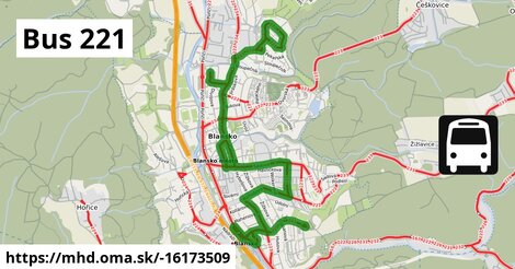
Zastávky popri linke:
Blansko, Zborovce ¤,
Blansko, Okružní ¤,
Blansko, náměstí Míru ¤,
Blansko, pošta ¤,
Blansko, Písečná, penzion ¤,
Blansko, náměstí Republiky ¤,
Blansko, náměstí Republiky ¤,
Blansko, pošta ¤,
Blansko, Bezručova ¤,
Blansko, Seifertova ¤,
Blansko, poliklinika ¤,
Blansko, aut. st. ¤,
Blansko, supermarket Albert ¤,
Blansko, náměstí Svobody ¤,
Blansko, náměstí Míru ¤,
Blansko, poliklinika ¤,
Blansko, Písečná, hotel Probe ¤,
Blansko, Bezručova ¤,
Blansko, Písečná ¤,
Blansko, aut. st. ¤,
Tabák Nečas ¤,
Blansko, aut. st. ¤,
Blansko, aut. st. ¤,
Blansko, aut. st. ¤,
Blansko, aut. st. ¤,
Blansko, aut. st. ¤,
Blansko, aut. st. ¤,
Blansko, aut. st. ¤,
Blansko, aut. st. ¤,
Blansko, aut. st. ¤Má spoločné úseky s linkami:
Bus 152: Blansko ⇒ Lipůvka ⇒ Kuřim ¤ ,
Bus 152: Kuřim ⇒ Lipůvka ⇒ Svinošice, náves ⇒ Blansko ¤ ,
Bus 235 ¤ ,
Bus 234 ¤ ,
Bus 233 ¤ ,
Bus 231 ¤ ,
Bus 232 ¤ ,
Bus 226 ¤ ,
Bus 230 ¤ ,
Bus 224 ¤ ,
Bus 223 ¤ ,
Bus 222 ¤ ,
Bus 167 ¤ ,
Bus 152: Kuřim ⇒ Lipůvka ⇒ Blansko ¤ Ide po uliciach:
Bartošova ¤ ,
Kamnářská ¤ ,
náměstí Republiky ¤ ,
Na Řadech ¤ ,
Okružní ¤ ,
Seifertova ¤ ,
Sušilova ¤ ,
Svitavská ¤ ,
Zborovecká ¤ ,
nám. Svobody ¤ ,
Bezručova ¤ ,
L. Janáčka ¤ ,
Nádražní ¤ ,
9. května ¤ ,
Sadová ¤ ,
Masarykova ¤ Trasa vedie cez obce
Blansko: 7,0 km (100 %),
Podobné linky 221:
ine: Bus 221: Gramatneusiedl Bahnhof = > Fischamend Bahnhof, ,
ine: Bus 221: Čadca, aut.st. = > Oščadnica, Vreščovka, ,
ine: Bus 221: Fischamend Bahnhof = > Gramatneusiedl Bahnhof, ,
ine: Bus 221: Rauchenwarth Kirchenplatz = > Schwadorf Schulgasse, ,
ine: Bus 221: Fischamend Bahnhof = > Enzersdorf an der Fischa = > Guntramsdorf Lokalbahn, ,
ine: Bus 221: Fischamend Bahnhof = > Flughafen Wien Busterminal, ,
ine: Bus 221: Fischamend Bahnhof = > Rauchenwarth Kirchenplatz, ,
ine: Bus 221: Kleinneusiedl Schwadorfer Straße = > Fischamend Bahnhof, ,
ine: Bus 221: Flughafen Wien Busterminal = > Guntramsdorf Lokalbahn, ,
ine: Bus 221: Schwadorf Volksschule = > Rauchenwarth Kirchenplatz, ,
ine: Bus 221: Flughafen Wien Busterminal = > Gramatneusiedl Bahnhof, ,
ine: Bus 221: Rauchenwarth Kirchenplatz = > Flughafen Wien Busterminal, ,
ine: Bus 221: Fischamend Bahnhof = > Guntramsdorf Lokalbahn, ,
ine: Bus 221: Gramatneusiedl Bahnhof = > Flughafen Wien Busterminal, ,
ine: Bus 221: Guntramsdorf Lokalbahn = > Fischamend Bahnhof, ,
ine: 221, ,
ine: Bus 221: Oščadnica, Vreščovka = > Čadca, aut.st.,
Viac info:
aktualizovať mapu,
uprav v JOSM (pokročilé),
-16173509,
stiahni GPX, route: bus, to: Okružní, from: Nádraží, network: IDS JMK, route name: Bus 221, osm version: 2, osm changeset: 0, osm timestamp: 2024 10 26T16:55:54Z, Q12020731, dlzka: 7040, pocet seg: 14, lon: 16.6492, lat: 49.3623, povodna farba: cad blansko,
Zdroj dát
Mapové údaje pochádzajú z
www.OpenStreetMap.org, databáza je prístupná pod licenciou
ODbL.

Mapový podklad vytvára a aktualizuje
Freemap Slovakia (www.freemap.sk), šíriteľný pod licenciou CC-BY-SA. Fotky sme čerpali z galérie portálu freemap.sk, autori fotiek sú uvedení pri jednotlivých fotkách a sú šíriteľné pod licenciou CC a z wikipédie. Výškový profil trás čerpáme z
SRTM. Niečo vám chýba?
Pridajte to. Sme radi, že tvoríte slobodnú wiki mapu sveta.