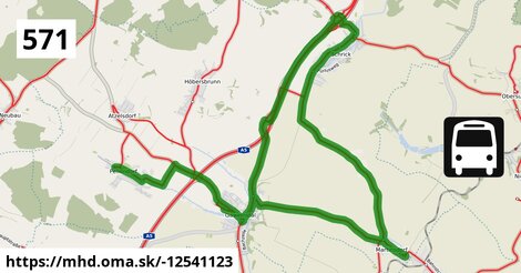
Cesta: OMA » Doprava » iná » bus » Bus 571: Pellendorf Feuerwehr = > Martinsdorf Winzerstraße = > Gaweinstal Volksschule

Bus 571: Pellendorf Feuerwehr = > Martinsdorf Winzerstraße = > Gaweinstal Volksschule

dĺžka 22 km , spravuje Gschwindl, číslo trasy 571, názvy: Bus 571: Pellendorf Feuerwehr => Martinsdorf Winzerstraße => Gaweinstal Volksschule

Zastávky popri linke:

Pellendorf Feuerwehr po 0 m ¤, Pellendorf Pfaffenwaldweg po 0,75 km ¤, Pellendorf bei Mistelbach Pfaffenwaldweg po 0,79 km ¤, Gaweinstal Volksschule po 3,6 km ¤, Gaweinstal Hauptplatz po 4,1 km ¤, Gaweinstal Hauptplatz po 4,2 km ¤, Gaweinstal Martinsdorferstraße po 4,7 km ¤, Gaweinstal Martinsdorferstraße po 4,8 km ¤, Martinsdorf Kirche (Ahornstraße) po 8,4 km ¤, Martinsdorf Kirche (Winzerstraße) po 8,5 km ¤, Martinsdorf Winzerstraße po 9,0 km ¤, Martinsdorf Winzerstraße po 9,0 km ¤, Martinsdorf Kirche (Lindenallee) po 9,8 km ¤, Schrick Josef-Weiland-Straße 81 po 14,2 km ¤, Schrick Josef-Weiland-Straße 81 po 14,2 km ¤, Schrick Ortsmitte po 15 km ¤, Schrick Ortsmitte po 15 km ¤, Schrick Hobersdorfer Straße po 16 km ¤, Schrick Hobersdorfer Straße po 16 km ¤, Gaweinstal Brünner Straße po 21 km ¤, Gaweinstal Brünner Straße po 21 km ¤, Gaweinstal Gemeindeamt po 21 km ¤, Gaweinstal Gemeindeamt po 21 km ¤, Gaweinstal Volksschule po 22 km ¤

prestupné linky:

Bus 500: Wolkersdorf Bahnhof = > Gaweinstal Hauptplatz po 4,2 km ¤

Má spoločné úseky s linkami:

Bus 571: Martinsdorf Winzerstraße = > Mistelbach Bahnhof po 0,81 km ¤ , Bus 571: Mistelbach Bahnhof = > Gaweinstal Hauptplatz po 2,6 km ¤ , Bus 571: Gaweinstal Hauptplatz = > Mistelbach Bahnhof po 2,6 km ¤ , Bus 571: Höbersbrunn Obere Landstraße = > Gaweinstal Hauptplatz po 2,6 km ¤ , Bus 571: Gaweinstal Hauptplatz = > Mistelbach Bahnhof (via Mistelbach Alleegasse) po 2,6 km ¤ , Bus 571: Gaweinstal Hauptplatz = > Pellendorf Feuerwehr (mit Halt in Gaweinstal Volksschule) po 2,7 km ¤ , Bus 571: Gaweinstal Hauptplatz = > Pellendorf Feuerwehr = > Gaweinstal Hauptplatz po 3,8 km ¤ , Bus 571: Mistelbach Alleegasse = > Klein-Harras Hauptstraße po 3,8 km ¤ , Bus 571: Mistelbach Bahnhof = > Klein-Harras Hauptstraße po 3,8 km ¤ , Bus 571: Mistelbach Alleegasse = > Martinsdorf Winzerstraße po 3,8 km ¤ , Bus 571: Mistelbach Bahnhof = > Martinsdorf Winzerstraße po 3,8 km ¤ , Bus 571: Bad Pirawarth = > Gaweinstal Volksschule po 4,0 km ¤ , Bus 571: Gaweinstal Volksschule = > Bad Pirawarth Untere Hauptstraße po 4,1 km ¤ , Bus 500: Schrick Hobersdorfer Straße = > Wolkersdorf Bahnhof po 4,4 km ¤ , Bus 500: Schrick Hobersdorfer Straße = > Wien Floridsdorf po 4,4 km ¤ , Bus 505: Wien Floridsdorf = > Zistersdorf Schloßplatz (über Niedersulz Museumsdorf und Obersulz Ortsmitte) po 8,5 km ¤ , Bus 505: Wien Floridsdorf = > Zistersdorf Schloßplatz (über Obersulz Ortsmitte) po 8,5 km ¤ , Bus 534: Hohenruppersdorf Gemeindeamt = > Gänserndorf Siebenbrunner Straße po 8,5 km ¤ , Bus 505: Wolkersdorf Bahnhof = > Zistersdorf Schloßplatz (über Niedersulz Museumsdorf) po 8,5 km ¤ , Bus 505: Zistersdorf Schloßplatz = > Wien Floridsdorf (über Niedersulz Museumsdorf) po 8,5 km ¤ , Bus 505: Wien Floridsdorf = > Zistersdorf Schloßplatz (über Niedersulz Museumsdorf) po 8,5 km ¤ , Bus 505: Wien Floridsdorf = > Zistersdorf Schloßplatz po 8,5 km ¤ , Bus 505: Wolkersdorf Bahnhof = > Zistersdorf Schloßplatz po 8,5 km ¤ , Bus 505: Zistersdorf Schloßplatz = > Wolkersdorf Bahnhof (über Niedersulz Museumsdorf) po 8,5 km ¤ , Bus 505: Zistersdorf Schloßplatz = > Wien Floridsdorf po 8,5 km ¤ , Bus 505: Zistersdorf Schloßplatz = > Wolkersdorf Bahnhof (über Niedersulz Museumsdorf und Obersulz Ortsmitte) po 8,5 km ¤ , Bus 505: Zistersdorf Schloßplatz = > Wien Floridsdorf (über Niedersulz Museumsdorf und Obersulz Ortsmitte) po 8,5 km ¤ , Bus 505: Zistersdorf Schloßplatz = > Wolkersdorf Bahnhof po 8,5 km ¤ , Bus 505: Zistersdorf Schloßplatz = > Wien Floridsdorf (über Obersulz Ortsmitte) po 8,5 km ¤ , Bus 534: Matzen Schule = > Obersulz Ortsmitte po 9,1 km ¤ , Bus 534: Gänserndorf Bahnhof = > Zistersdorf Schloßplatz po 9,1 km ¤ , Bus 534: Matzen Schule = > Hohenruppersdorf Marktplatz po 9,1 km ¤ , Bus 534: Matzen Schule = > Zistersdorf Schloßplatz po 9,1 km ¤ , Bus 595: Wien Opelwerk = > Laa an der Thaya Stadtplatz po 14,0 km ¤ , Bus 150: Wien Floridsdorf = > Bernhardsthal Bahnhof po 14,0 km ¤ , Bus 571: Gaweinstal Hauptplatz = > Atzelsdorf Kirche = > Schrick Josef-W.-Str. 81 (via B7) po 14,0 km ¤ , Bus 571: Gaweinstal Hauptplatz = > Pellendorf Feuerwehr = > Martinsdorf Winzerstraße = > Gaweinstal Hauptplatz po 14,0 km ¤ , Bus 500: Wien Floridsdorf = > Mistelbach Bahnhof po 14,0 km ¤ , Bus 535: Gänserndorf Bahnhof = > Mistelbach Bahnhof po 14,0 km ¤ , Bus 595: Laa an der Thaya Stadtplatz = > Wien Opelwerk po 14,0 km ¤ , Bus 535: Gänserndorf Bahnhof = > Mistelbach Bahnhof po 14,0 km ¤ , Bus 535: Mistelbach Bahnhof = > Gänserndorf Bahnhof po 14,0 km ¤ , Bus 571: Gaweinstal Volksschule = > Martinsdorf Winzerstraße (via Schrick) po 14,0 km ¤ , Bus 500: Mistelbach Bahnhof = > Wien Floridsdorf po 14,0 km ¤ , Bus 571: Gaweinstal Hauptplatz = > Martinsdorf Winzerstraße = > Mistelbach Bahnhof (via Schrick, Ebendorf) po 14,0 km ¤ , Bus 150: Bernhardsthal Bahnhof = > Wien Floridsdorf po 14,0 km ¤ , Bus 500: Wien Floridsdorf = > Schrick Hobersdorfer Straße po 15 km ¤ , Bus 565: Mistelbach Bahnhof = > Dürnkrut Bahnhof (via Ebenthal) po 16 km ¤ , Bus 565: Dürnkrut Bahnhof = > Mistelbach Bahnhof po 16 km ¤ , Bus 565: Mistelbach Bahnhof = > Spannberg Hauptplatz po 16 km ¤ , Bus 565: Mistelbach Bahnhof = > Dürnkrut Bahnhof po 16 km ¤ , Bus 565: Niedersulz Kirche = > Mistelbach Bahnhof po 16 km ¤ , Bus 565: Mistelbach Bahnhof = > Niedersulz Kirche po 16 km ¤ , Bus 565: Mistelbach Bahnhof = > Dürnkrut Bahnhof (via Niedersulz Museumsdorf) po 16 km ¤ , Bus 565: Dürnkrut Bahnhof = > Mistelbach Bahnhof (via Niedersulz Museumsdorf) po 16 km ¤ , Bus 150: Wilfersdorf bei Mistelbach Marktplatz = > Schrick Hobersdorfer Straße po 16 km ¤ , Bus 571: Schrick = > Mistelbach Bahnhof (via A5, Gaweinstal, Höbersbrunn) po 18 km ¤ , Flixbus 060: Berlin ZOB = > Wien Erdberg, Busterminal VIB po 19 km ¤ , Flixbus N1395: Gdynia, dworzec autobusowy = > Wien Erdberg, Busterminal VIB po 19 km ¤ , Flixbus N903: Praha, ÚAN Florenc = > Zagreb, autobusna stanica po 19 km ¤ , Flixbus 916: Kraków, przystanek autobusowy MDA = > Wien Erdberg, Busterminal VIB po 19 km ¤ , Flixbus N906: Praha, ÚAN Florenc = > Split, autobusna stanica po 19 km ¤ , Flixbus N66: Hamburg ZOB = > Wien, Flughafen Schwechat po 19 km ¤ , Flixbus N958: Berlin ZOB = > Rijeka, autobusna stanica po 19 km ¤ , Flixbus 919: Wrocław, dworzec autobusowy = > Wien, Flughafen Schwechat po 19 km ¤ , Flixbus 167: Halle(Saale) ZOB = > Wien Erdberg, Busterminal VIB po 19 km ¤ , Flixbus 895: Brno, autobusové nádraží Hotel Grand = > Zagreb, autobusni kolodvor po 19 km ¤ , Flixbus 366: Praha, ÚAN Florenc = > Wien Erdberg, Busterminal VIB po 19 km ¤ , Flixbus N60: Berlin ZOB = > Zagreb, autobusna stanica po 19 km ¤ , Flixbus N918: Dworzec autobusowy Warszawa Zachodnia = > Wien, Hbf. (International Busterminal) po 19 km ¤ , Flixbus 958: Praha, ÚAN Florenc = > Crikvenica, autobusna stanica po 19 km ¤ , Bus 151: Wildendürnbach Ortsmitte = > Wien Floridsdorf po 19 km ¤ , Flixbus 918: Dworzec autobusowy Warszawa Zachodnia = > Wien, Hbf. (International Busterminal) po 19 km ¤

Podobné linky 571:

ine: Bus 571: Martinsdorf Winzerstraße = > Mistelbach Bahnhof, , ine: Bus 571: Gaweinstal Hauptplatz = > Pellendorf Feuerwehr = > Gaweinstal Hauptplatz, , ine: Bus 571: Gaweinstal Hauptplatz = > Mistelbach Bahnhof (via Mistelbach Alleegasse), , ine: Bus 571: Gaweinstal Hauptplatz = > Pellendorf Feuerwehr = > Martinsdorf Winzerstraße = > Gaweinstal Hauptplatz, , ine: Bus 571: Schrick = > Mistelbach Bahnhof (via A5, Gaweinstal, Höbersbrunn), , ine: Bus 571: Mistelbach Alleegasse = > Martinsdorf Winzerstraße, , ine: Bus 571: Mistelbach Bahnhof = > Gaweinstal Hauptplatz, , ine: Bus 571: Mistelbach Bahnhof = > Klein-Harras Hauptstraße, , ine: Bus 571: Lanzendorf bei Mistelbach Schricker Straße = > Mistelbach Bahnhof (via Mistelbach Alleegasse), , ine: Bus 571: Gaweinstal Hauptplatz = > Atzelsdorf Kirche = > Schrick Josef-W.-Str. 81 (via B7), , ine: Bus 571: Klein-Harras Hauptstraße = > Kollnbrunn Brünner Straße, , ine: Bus 571: Gaweinstal Hauptplatz = > Mistelbach Bahnhof, , ine: Bus 571: Gaweinstal Volksschule = > Bad Pirawarth Untere Hauptstraße, , ine: Bus 571: Gaweinstal Hauptplatz = > Pellendorf Feuerwehr (mit Halt in Gaweinstal Volksschule), , ine: Bus 571: Gaweinstal Volksschule = > Martinsdorf Winzerstraße (via Schrick), , ine: Bus 571: Gaweinstal Hauptplatz = > Martinsdorf Winzerstraße = > Mistelbach Bahnhof (via Schrick, Ebendorf), , ine: Bus 571: Höbersbrunn Obere Landstraße = > Gaweinstal Hauptplatz, , ine: Bus 571: Mistelbach Bahnhof = > Martinsdorf Winzerstraße, , ine: Bus 571, , ine: Bus 571: Bad Pirawarth = > Gaweinstal Volksschule, , ine: Bus 571: Mistelbach Alleegasse = > Klein-Harras Hauptstraße,
Viac info: aktualizovať mapu, uprav v JOSM (pokročilé), -12541123,
Súradnice: 48°29'21"N, 16°36'18"E
stiahni GPX, najbližšia MHD, route: bus, to: Gaweinstal Volksschule, via: Martinsdorf Bergring, from: Pellendorf Feuerwehr, network: VOR, osm uid: 0, route name: Bus 571: Pellendorf Feuerwehr => Martinsdorf Winzerstraße => Gaweinstal Volksschule, osm version: 9, osm changeset: 0, osm timestamp: 2023 10 09T16:29:38Z, Q2516485, de:Verkehrsverbund Ost Region, 2, dlzka: 21726, pocet seg: 1, lon: 16.6052, lat: 48.4894, povodna farba: gschwindl,
Bus 571: Pellendorf Feuerwehr = >  Martinsdorf Winzerstraße = >  Gaweinstal Volksschule

Viac o nás

Podpor projekt OMA:

QR kód na túto stránku mhd.oma.sk -12541123

Spojte sa s nami na facebooku, zdieľajte túto stránku na Facebooku, na Twittri, alebo umiestnite odkaz na svoju stránku.

Ale hlavne doplňte dáta do Openstreetmap, články do wikipédie, ...

Zdroj dát

Mapové údaje pochádzajú z www.OpenStreetMap.org, databáza je prístupná pod licenciou ODbL. OMA logoMapový podklad vytvára a aktualizuje Freemap Slovakia (www.freemap.sk), šíriteľný pod licenciou CC-BY-SA. Fotky sme čerpali z galérie portálu freemap.sk, autori fotiek sú uvedení pri jednotlivých fotkách a sú šíriteľné pod licenciou CC a z wikipédie. Výškový profil trás čerpáme z SRTM. Niečo vám chýba? Pridajte to. Sme radi, že tvoríte slobodnú wiki mapu sveta.