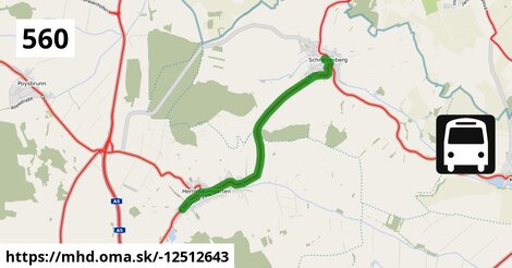
Zastávky na linke
Herrnbaumgarten Hauptstraße 5a po 2 m ¤,
Herrnbaumgarten Ortsmitte po 532 m ¤,
Herrnbaumgarten Sportplatz po 1,23 km ¤,
Herrnbaumgarten Liechtensteinsiedlung po 1,78 km ¤,
Schrattenberg Friedhof po 4,7 km ¤,
Schrattenberg Kirchenplatz po 5,5 km ¤,
Schrattenberg Gemeindeamt po 6,2 km ¤,
Schrattenberg Volksschule po 6,4 km ¤Zastávky popri linke:
Herrnbaumgarten Hauptstraße 5a po ¤,
Herrnbaumgarten Hauptstraße 5a po 2 m ¤,
Herrnbaumgarten Ortsmitte po 513 m ¤,
Herrnbaumgarten Ortsmitte po 532 m ¤,
Herrnbaumgarten Volksschule po 660 m ¤,
Herrnbaumgarten Volksschule po 660 m ¤,
Herrnbaumgarten Sportplatz po 1,15 km ¤,
Herrnbaumgarten Sportplatz po 1,23 km ¤,
Herrnbaumgarten Liechtensteinsiedlung po 1,78 km ¤,
Herrnbaumgarten Liechtensteinsiedlung po 1,78 km ¤,
Schrattenberg Friedhof po 4,7 km ¤,
Schrattenberg Friedhof po 4,7 km ¤,
Schrattenberg Kirchenplatz po 5,5 km ¤,
Schrattenberg Kirchenplatz po 5,5 km ¤,
Schrattenberg Gemeindeamt po 6,2 km ¤,
Schrattenberg Volksschule po 6,4 km ¤Má spoločné úseky s linkami:
Bus 582: Laa an der Thaya Bahnhof = > Schrattenberg Kirchenplatz po 580 m ¤ ,
Bus 582: Schrattenberg Kirchenplatz = > Laa an der Thaya Gymnasium po 580 m ¤ ,
Bus 560: Schrattenberg Kirchenplatz = > Mistelbach Bahnhof po 1,19 km ¤ ,
IDS JMK: Rufbus 555 po 2,0 km ¤ ,
Bus 560: Schrattenberg Volksschule = > Herrnbaumgarten Volksschule po 2,0 km ¤ ,
Bus 560: Mistelbach Bahnhof = > Bernhardsthal Bahnhof po 5,5 km ¤ ,
Bus 560: Mistelbach Bahnhof = > Bernhardsthal Kirche (Volksschule) = > Bernhardsthal Bahnhof po 5,5 km ¤ ,
Bus 560: Herrnbaumgarten Volksschule = > Schrattenberg Volksschule po 5,5 km ¤ ,
Bus 150: Bernhardsthal Bahnhof = > Wien Floridsdorf po 5,5 km ¤ ,
Bus 560: Poysdorf Volksschule = > Bernhardsthal Bahnhof po 5,5 km ¤ ,
Bus 560: Bernhardsthal Bahnhof = > Poysdorf Mittelschule po 5,5 km ¤ ,
Bus 560: Bernhardsthal Bahnhof = > Mistelbach Bahnhof po 5,5 km ¤ ,
Bus 560: Bernhardsthal Bahnhof = > Mistelbach Alleegasse = > Mistelbach Bahnhof po 5,5 km ¤ ,
Bus 560: Bernhardsthal Bahnhof = > Bernhardsthal Kirche = > Poysdorf Mittelschule = > Mistelbach Bahnhof po 5,5 km ¤ ,
Bus 150: Wien Floridsdorf = > Bernhardsthal Bahnhof po 5,5 km ¤ ,
Bus 560: Poysdorf Dreifaltigkeitsplatz = > Bernhardsthal Bahnhof po 5,5 km ¤ Podobné linky 560:
ine: Bus 560: Herrnbaumgarten Volksschule = > Schrattenberg Volksschule, ,
ine: Bus 560: Schrattenberg Volksschule = > Herrnbaumgarten Volksschule, ,
ine: Bus 560: Bernhardsthal Bahnhof = > Katzelsdorf im Weinviertel Ortsmitte, ,
ine: Bus 560: Mistelbach Bahnhof = > Poysdorf Dreifaltigkeitsplatz, ,
ine: Bus 560: Poysdorf Volksschule = > Bernhardsthal Bahnhof, ,
ine: Bus 560: Bernhardsthal Bahnhof = > Bernhardsthal Kirche = > Poysdorf Mittelschule = > Mistelbach Bahnhof, ,
ine: Bus 560: Bernhardsthal Bahnhof = > Mistelbach Alleegasse = > Mistelbach Bahnhof, ,
ine: Bus 560: Mistelbach Bahnhof = > Bernhardsthal Bahnhof, ,
ine: Bus 560: Schrattenberg Kirchenplatz = > Mistelbach Bahnhof, ,
ine: Bus 560: Poysdorf Dreifaltigkeitsplatz = > Poysdorf Mittelschule = > Mistelbach Bahnhof, ,
ine: Bus 560: Bernhardsthal Bahnhof = > Mistelbach Bahnhof, ,
ine: Bus 560: Mistelbach Bahnhof = > Bernhardsthal Kirche (Volksschule) = > Bernhardsthal Bahnhof, ,
ine: Bus 560: Poysdorf Dreifaltigkeitsplatz = > Bernhardsthal Bahnhof, ,
ine: Bus 560: Poysdorf Dreifaltigkeitsplatz = > Mistelbach Bahnhof, ,
ine: Bus 560: Bernhardsthal Bahnhof = > Poysdorf Mittelschule,
Viac info:
aktualizovať mapu,
uprav v JOSM (pokročilé),
-12512643,
stiahni GPX, route: bus, to: Schrattenberg Volksschule, from: Herrnbaumgarten Hauptstraße 5a, network: VOR, route name: Bus 560: Herrnbaumgarten Hauptstraße 5a => Schrattenberg Volksschule, osm version: 8, osm changeset: 0, osm timestamp: 2026 05 19T10:18:53Z, Q2516485, 2, dlzka: 6404, pocet seg: 1, lon: 16.7031, lat: 48.7101, povodna farba: gschwindl komet,
Zdroj dát
Mapové údaje pochádzajú z
www.OpenStreetMap.org, databáza je prístupná pod licenciou
ODbL.

Mapový podklad vytvára a aktualizuje
Freemap Slovakia (www.freemap.sk), šíriteľný pod licenciou CC-BY-SA. Fotky sme čerpali z galérie portálu freemap.sk, autori fotiek sú uvedení pri jednotlivých fotkách a sú šíriteľné pod licenciou CC a z wikipédie. Výškový profil trás čerpáme z
SRTM. Niečo vám chýba?
Pridajte to. Sme radi, že tvoríte slobodnú wiki mapu sveta.