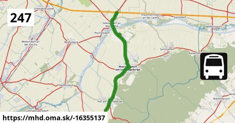
Cesta: OMA » Doprava » iná » bus » Bus 247: Götzendorf Bahnhof = > Au am Leithaberge Hauptplatz

Bus 247: Götzendorf Bahnhof = > Au am Leithaberge Hauptplatz

dĺžka 12,3 km , spravuje Österreichische Postbus AG;Blaguss, číslo trasy 247, názvy: Bus 247: Götzendorf Bahnhof => Au am Leithaberge Hauptplatz

Zastávky na linke

Götzendorf Bahnhof po 1 m ¤, Götzendorf Hauptplatz po 1,48 km ¤, Götzendorf Militärsiedlung Sommerein po 3,0 km ¤, Mannersdorf am Leithagebirge Güterbahnhof po 6,4 km ¤, Mannersdorf am Leithagebirge Hauptstraße po 6,9 km ¤, Mannersdorf am Leithagebirge Volksschule po 7,4 km ¤, Mannersdorf am Leithagebirge Hofer Straße po 7,9 km ¤, Mannersdorf am Leithagebirge Arbachmühle po 9,5 km ¤, Hof am Leithaberge Mannersdorfer Straße po 10,8 km ¤, Hof am Leithaberge Hauptplatz po 11,3 km ¤, Hof am Leithaberge Auer Straße po 11,6 km ¤

Zastávky popri linke:

Götzendorf Bahnhof po 1 m ¤, Götzendorf Hauptplatz po 1,48 km ¤, Götzendorf Hauptplatz po 1,53 km ¤, Götzendorf Militärsiedlung Sommerein po 2,7 km ¤, Götzendorf Militärsiedlung Sommerein po 3,0 km ¤, Mannersdorf am Leithagebirge Güterbahnhof po 6,4 km ¤, Mannersdorf am Leithagebirge Güterbahnhof po 6,5 km ¤, Mannersdorf am Leithagebirge Hauptstraße po 6,9 km ¤, Mannersdorf am Leithagebirge Hauptstraße po 6,9 km ¤, Mannersdorf am Leithagebirge Volksschule po 7,4 km ¤, Mannersdorf am Leithagebirge Volksschule po 7,5 km ¤, Mannersdorf am Leithagebirge Hofer Straße po 7,8 km ¤, Mannersdorf am Leithagebirge Hofer Straße po 7,9 km ¤, Mannersdorf am Leithagebirge Arbachmühle po 9,5 km ¤, Mannersdorf am Leithagebirge Arbachmühle po 9,5 km ¤, Hof am Leithaberge Mannersdorfer Straße po 10,8 km ¤, Hof am Leithaberge Mannersdorfer Straße po 10,9 km ¤, Hof am Leithaberge Hauptplatz po 11,3 km ¤, Hof am Leithaberge Hauptplatz po 11,3 km ¤, predaj lístkov po 11,3 km ¤, Hof am Leithaberge Auer Straße po 11,6 km ¤, Hof am Leithaberge Auer Straße po 11,6 km ¤

Automaty na lístky:

predaj lístkov po 11,3 km ¤

Má spoločné úseky s linkami:

Bus 227: Wien Oberlaa = > Ebreichsdorf Georg-Drasche-Siedlung (über Seibersdorf Unterzeile) po 39 m ¤ , Bus 227: Wien Oberlaa = > Ebreichsdorf Georg-Drasche-Siedlung po 39 m ¤ , Bus 227: Reisenberg Hauptplatz = > Wien Oberlaa po 39 m ¤ , Bus 227: Ebreichsdorf Georg-Drasche-Siedlung = > Wien Oberlaa po 39 m ¤ , Bus 277: Bruck an der Leitha Neue Mittelschule = > Mannersdorf am Leithagebirge Volksschule po 6,9 km ¤ , Bus 277: Bruck an der Leitha Gymnasium/HAK = > Mannersdorf am Leithagebirge Volksschule po 6,9 km ¤ , Bus 277: Mannersdorf am Leithagebirge Volksschule = > Bruck an der Leitha Volksschule (über Wilfleinsdorf Kirche) po 7,4 km ¤ , Bus 277: Mannersdorf am Leithagebirge Volksschule = > Bruck an der Leitha Neue Mittelschule po 7,4 km ¤ , Bus 277: Mannersdorf am Leithagebirge Volksschule = > Bruck an der Leitha Volksschule (über Bruck an der Leitha Gymnasium/HAK, nicht über Bruck an der Leitha Industriegelände West) po 7,4 km ¤ , Bus 248: Schwadorf Schulgasse = > Gramatneusiedl Bahnhof (über Reisenberg Hermannstadtstraße) po 7,6 km ¤ , Bus 248: Schwadorf Schulgasse = > Ebergassing Schulen (über Reisenberg Hermannstadtstraße) po 7,6 km ¤ , Bus 248: Margareten am Moos Wiener Straße = > Gramatneusiedl Bahnhof (über Reisenberg Hermannstadtstraße) po 7,6 km ¤ , Bus 248: Schwadorf Schulgasse = > Gramatneusiedl Bahnhof po 7,6 km ¤ , Bus 248: Götzendorf Volksschule = > Wasenbruck Kinderheimstraße po 7,6 km ¤ , Bus 248: Enzersdorf an der Fischa Volksschule = > Gramatneusiedl Bahnhof po 7,6 km ¤ , Bus 248: Margareten am Moos Wiener Straße = > Gramatneusiedl Bahnhof po 7,6 km ¤ , Bus 248: Gramatneusiedl Bahnhof = > Schwadorf Schulgasse po 7,6 km ¤ , Bus 248: Gramatneusiedl Bahnhof = > Götzendorf Bahnhof po 7,6 km ¤ , Bus 248: Ebergassing Schulen = > Schwadorf Schulgasse po 7,6 km ¤ , Bus 248: Gramatneusiedl Bahnhof = > Schwadorf Schulgasse (über Reisenberg Hermannstadtstraße) po 7,6 km ¤ , Bus 248: Gramatneusiedl Bahnhof = > Enzersdorf an der Fischa Volksschule (über Reisenberg Hermannstadtstraße) po 7,6 km ¤ , Bus 248: Gramatneusiedl Bahnhof = > Margarethen am Moos Wiener Straße po 7,6 km ¤ , Bus 248: Wasenbruck Kinderheimstraße = > Mannersdorf am Leithagebirge Hauptstraße po 7,6 km ¤ , Bus 248: Gramatneusiedl Bahnhof = > Margareten am Moos Wiener Straße (über Reisenberg Hermannstadtstraße) po 7,6 km ¤ , Bus 248: Mannersdorf am Leithagebirge Hofer Straße = > Reisenberg Hauptplatz (über Reisenberg Hermannstadtstraße) po 7,6 km ¤ , Bus 248: Reisenberg Hauptplatz = > Mannersdorf am Leithagebirge Hofer Straße (über Reisenberg Hermannstadtstraße) po 7,8 km ¤ , Bus 280: Mannersdorf Hauptstraße = > Eisenstadt Domplatz po 11,1 km ¤ , Bus 277: Eisenstadt Domplatz = > Bruck an der Leitha Neue Mittelschule po 12,3 km ¤ , Bus 277: Mannersdorf am Leithagebirge Hofer Straße = > Eisenstadt Domplatz po 12,3 km ¤ , Bus 277: Stotzing Ortsmitte = > Bruck an der Leitha Volksschule po 12,3 km ¤ , Bus 277: Bruck an der Leitha Gymnasium/HAK = > Eisenstadt Domplatz po 12,3 km ¤ , Bus 277: Bruck an der Leitha Gymnasium/HAK = > Stotzing Ortsmitte po 12,3 km ¤ , Bus 277: Eisenstadt Domplatz = > Mannersdorf am Leithagebirge Hauptstraße po 12,3 km ¤ , Bus 277: Eisenstadt Domplatz = > Mannersdorf am Leithagebirge Hofer Straße po 12,3 km ¤ , Bus 277: Bruck an der Leitha Volksschule = > Eisenstadt Domplatz po 12,3 km ¤ , Bus 277: Mannersdorf am Leithagebirge Hauptstraße = > Eisenstadt Domplatz po 12,3 km ¤ , Bus 277: Mannersdorf am Leithagebirge Hauptstraße = > Eisenstadt Oberberg po 12,3 km ¤ , Bus 277: Stotzing Ortsmitte = > Bruck an der Leitha Neue Mittelschule po 12,3 km ¤ , Bus 277: Bruck an der Leitha Neue Mittelschule = > Eisenstadt Domplatz po 12,3 km ¤ , Bus 277: Bruck an der Leitha Volksschule = > Eisenstadt Domplatz (über Wilfleinsdorf Kirche) po 12,3 km ¤ , Bus 277: Sommerein Kirchenplatz = > Eisenstadt Domplatz po 12,3 km ¤ , Bus 247: Au am Leithaberge Hauptplatz = > Götzendorf Bahnhof po 12,3 km ¤ , Bus 247: Götzendorf Bahnhof = > Ebreichsdorf Georg-Drasche-Siedlung po 12,3 km ¤ , Bus 247: Seibersdorf Volksschule = > Götzendorf Bahnhof po 12,3 km ¤ , Bus 247: Deutsch Brodersdorf Ortsmitte = > Götzendorf Bahnhof po 12,3 km ¤ , Bus 247: Götzendorf Bahnhof = > Seibersdorf Volksschule po 12,3 km ¤ , Bus 247: Ebreichsdorf Bahnhof = > Götzendorf Bahnhof po 12,3 km ¤ , Bus 277: Eisenstadt Domplatz = > Mannersdorf am Leithagebirge Volksschule po 12,3 km ¤ , Bus 247: Unterwaltersdorf Don Bosco-Gymnasium = > Götzendorf Bahnhof (über Leithaprodersdorf Schulgasse) po 12,3 km ¤ , Bus 247: Unterwaltersdorf Don Bosco-Gymnasium = > Götzendorf Bahnhof po 12,3 km ¤ , Bus 247: Götzendorf Bahnhof = > Ebreichsdorf Georg-Drasche-Siedlung (über Unterwaltersdorf Gymnasium) po 12,3 km ¤ , Bus 247: Mannersdorf Hauptstraße = > Ebreichsdorf Schulen (über Leithaprodersdorf Schulgasse und Unterwaltersdorf Gymnasium) po 12,3 km ¤ , Bus 247: Ebreichsdorf Georg-Drasche-Siedlung = > Mannersdorf am Leithagebirge Volksschule (über Unterwaltersdorf Don Bosco-Gymnasium) po 12,3 km ¤ , Bus 277: Bruck an der Leitha Gymnasium/HAK = > Stotzing Ortsmitte (nicht über Bruck an der Leitha Bahnhof) po 12,3 km ¤ , Bus 247: Ebreichsdorf Georg-Drasche-Siedlung = > Götzendorf Bahnhof (über Unterwaltersdorf Don Bosco-Gymnasium und Leithaprodersdorf Schulgasse) po 12,3 km ¤

Trasa vedie cez obce

Gemeinde Mannersdorf am Leithagebirge: 6,7 km (55 %), Gemeinde Hof am Leithaberge: 2,8 km (22.8 %), Katastralgemeinde Götzendorf an der Leitha: 1,93 km (15.7 %), Gemeinde Sommerein: 660 m (5.4 %),

Podobné linky 247:

ine: Bus 247: Au am Leithaberge Hauptplatz = > Götzendorf Bahnhof, , ine: Bus 247: Götzendorf Bahnhof = > Ebreichsdorf Georg-Drasche-Siedlung, , ine: Bus 247: Seibersdorf Volksschule = > Götzendorf Bahnhof, , ine: Bus 247: Deutsch Brodersdorf Ortsmitte = > Götzendorf Bahnhof, , ine: Bus 247: Götzendorf Bahnhof = > Seibersdorf Volksschule, , ine: Bus 247: Ebreichsdorf Bahnhof = > Götzendorf Bahnhof, , ine: Bus 247: Unterwaltersdorf Don Bosco-Gymnasium = > Götzendorf Bahnhof (über Leithaprodersdorf Schulgasse), , ine: Bus 247: Unterwaltersdorf Don Bosco-Gymnasium = > Götzendorf Bahnhof, , ine: Bus 247: Götzendorf Bahnhof = > Ebreichsdorf Georg-Drasche-Siedlung (über Unterwaltersdorf Gymnasium), , ine: Bus 247: Mannersdorf Hauptstraße = > Ebreichsdorf Schulen (über Leithaprodersdorf Schulgasse und Unterwaltersdorf Gymnasium), , ine: Bus 247: Ebreichsdorf Georg-Drasche-Siedlung = > Mannersdorf am Leithagebirge Volksschule (über Unterwaltersdorf Don Bosco-Gymnasium), , ine: Bus 247: Ebreichsdorf Georg-Drasche-Siedlung = > Götzendorf Bahnhof (über Unterwaltersdorf Don Bosco-Gymnasium und Leithaprodersdorf Schulgasse),
Viac info: aktualizovať mapu, uprav v JOSM (pokročilé), -16355137,
Súradnice: 47°58'55"N, 16°35'26"E
stiahni GPX, route: bus, to: Au am Leithaberge Hauptplatz, from: Götzendorf Bahnhof, network: VOR, osm uid: 0, route name: Bus 247: Götzendorf Bahnhof => Au am Leithaberge Hauptplatz, osm version: 8, osm changeset: 0, osm timestamp: 2024 11 28T14:06:11Z, Q2516485, de:Verkehrsverbund Ost Region, 2, dlzka: 12258, pocet seg: 1, lon: 16.5908, lat: 47.9820, povodna farba: osterreichische postbus a,
Bus 247: Götzendorf Bahnhof = >  Au am Leithaberge Hauptplatz

Viac o nás

Podpor projekt OMA:

QR kód na túto stránku mhd.oma.sk -16355137

Spojte sa s nami na facebooku, zdieľajte túto stránku na Facebooku, na Twittri, alebo umiestnite odkaz na svoju stránku.

Ale hlavne doplňte dáta do Openstreetmap, články do wikipédie, ...

Zdroj dát

Mapové údaje pochádzajú z www.OpenStreetMap.org, databáza je prístupná pod licenciou ODbL. OMA logoMapový podklad vytvára a aktualizuje Freemap Slovakia (www.freemap.sk), šíriteľný pod licenciou CC-BY-SA. Fotky sme čerpali z galérie portálu freemap.sk, autori fotiek sú uvedení pri jednotlivých fotkách a sú šíriteľné pod licenciou CC a z wikipédie. Výškový profil trás čerpáme z SRTM. Niečo vám chýba? Pridajte to. Sme radi, že tvoríte slobodnú wiki mapu sveta.