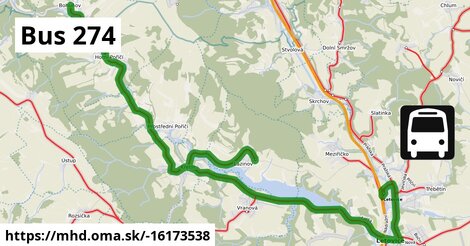
Zastávky popri linke:, 1 z 2
autobusová stanica ¤,
Letovice, přehrada ¤,
autobusová zastávka ¤,
Lazinov ¤,
autobusová zastávka ¤,
Lazinov, točna ¤,
autobusová zastávka ¤,
autobusová zastávka ¤,
autobusová zastávka ¤,
autobusová zastávka ¤,
autobusová zastávka ¤,
autobusová zastávka ¤,
Letovice, Letostroj I ¤,
autobusová zastávka ¤,
autobusová zastávka ¤,
autobusová zastávka ¤,
Letovice, přehrada ¤,
autobusová zastávka ¤,
autobusová zastávka ¤Zastávky popri linke:, 2 z 2
autobusová zastávka ¤,
Letovice, Letostroj I ¤,
Lazinov ¤,
autobusová zastávka ¤,
autobusová zastávka ¤,
autobusová zastávka ¤,
autobusová zastávka ¤,
autobusová zastávka ¤,
autobusová zastávka ¤,
autobusová zastávka ¤,
autobusová zastávka ¤,
autobusová zastávka ¤,
autobusová zastávka ¤,
autobusová zastávka ¤,
autobusová zastávka ¤,
autobusová stanica ¤,
autobusová zastávka ¤,
autobusová zastávka ¤Trasa vedie cez obce
Letovice: 4,8 km (29.2 %),
Křetín: 2,2 km (13.7 %),
Lazinov: 2,2 km (13.3 %),
Horní Poříčí u Letovic: 1,69 km (10.3 %),
Horní Poříčí: 1,69 km (10.3 %),
Vranová u Letovic: 1,69 km (10.3 %),
Prostřední Poříčí: 1,63 km (9.9 %),
Bohuňov nad Křetínkou: 1,11 km (6.8 %),
Meziříčko u Letovic: 524 m (3.2 %),
Dolní Poříčí nad Křetínkou: 394 m (2.4 %),
Podobné linky 274:
ine: Bus 274: Bruck an der Leitha Bahnhof = > Hainburg an der Donau Ungartor/B9, ,
ine: Bus 274: Bruck an der Leitha Bahnhof = > Wildungsmauer Gemeindeamt, ,
ine: Bus 274: Bruck an der Leitha Bahnhof = > Bruck an der Leitha Gymnasium/HAK = > Hainburg an der Donau Landesklinikum, ,
ine: Bus 274: Wildungsmauer Gemeindeamt = > Bruck an der Leitha Volksschule, ,
ine: Bus 274: Bruck an der Leitha Bahnhof = > Hainburg an der Donau Landesklinikum, ,
ine: Bus 274: Wildungsmauer Gemeindeamt = > Höflein Volksschule = > Bruck an der Leitha Bahnhof, ,
ine: Bus 274: Wildungsmauer Gemeindeamt = > Bruck an der Leitha Bahnhof, ,
ine: Bus 274: Bruck an der Leitha Bahnhof = > Bruck an der Leitha Gymnasium/HAK = > Wildungsmauer Gemeindeamt, ,
ine: Bus 274: Hainburg an der Donau Hauptplatz = > Bruck an der Leitha Bahnhof, ,
ine: Bus 274: Hainburg an der Donau Landesklinikum = > Bruck an der Leitha Bahnhof, ,
ine: Bus 274: Hainburg an der Donau Ungartor/B9 = > Bruck an der Leitha Bahnhof,
Viac info:
aktualizovať mapu,
uprav v JOSM (pokročilé),
-16173538,
stiahni GPX, route: bus, to: Bohuňov, from: Letovice, network: IDS JMK, route name: Bus 274, osm version: 5, osm changeset: 0, osm timestamp: 2025 08 21T20:04:27Z, Q12020731, dlzka: 16434, pocet seg: 7, lon: 16.5231, lat: 49.5644, povodna farba: csad tisnov,
Zdroj dát
Mapové údaje pochádzajú z
www.OpenStreetMap.org, databáza je prístupná pod licenciou
ODbL.

Mapový podklad vytvára a aktualizuje
Freemap Slovakia (www.freemap.sk), šíriteľný pod licenciou CC-BY-SA. Fotky sme čerpali z galérie portálu freemap.sk, autori fotiek sú uvedení pri jednotlivých fotkách a sú šíriteľné pod licenciou CC a z wikipédie. Výškový profil trás čerpáme z
SRTM. Niečo vám chýba?
Pridajte to. Sme radi, že tvoríte slobodnú wiki mapu sveta.