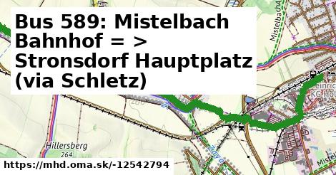
Cesta: OMA » Doprava » iná » bus » Bus 589: Mistelbach Bahnhof = > Stronsdorf Hauptplatz (via Schletz)

Bus 589: Mistelbach Bahnhof = > Stronsdorf Hauptplatz (via Schletz)

dĺžka 3,5 km , spravuje Dr. Richard NÖ, číslo trasy 589, názvy: Bus 589: Mistelbach Bahnhof => Stronsdorf Hauptplatz (via Schletz)

Zastávky na linke

H po 2 m ¤, Mistelbach Josef-Dunkl-Straße po 420 m ¤, Hüttendorf Weidengasse po 1,53 km ¤, Hüttendorf Wehrgasse po 2,2 km ¤, Hüttendorf Obere Landesstraße po 2,6 km ¤

Zastávky popri linke:

I po ¤, H po 2 m ¤, Mistelbach Josef-Dunkl-Straße po 378 m ¤, Mistelbach Josef-Dunkl-Straße po 420 m ¤, Hüttendorf Weidengasse po 1,53 km ¤, Hüttendorf Weidengasse po 1,53 km ¤, Hüttendorf Wehrgasse po 2,2 km ¤, Hüttendorf Wehrgasse po 2,2 km ¤, Hüttendorf Obere Landesstraße po 2,6 km ¤, Hüttendorf Obere Landesstraße po 2,7 km ¤

prestupné linky:

Bus 573: Mistelbach Kolpinghaus = > Hollabrunn Internat po 398 m ¤, Bus 573: Hollabrunn Internat = > Mistelbach Kolpinghaus po 398 m ¤, Bus 515: Wolkersdorf Bahnhof = > Mistelbach Bahnhof (über Ladendorf Brauhausgasse, nicht über Wolkersdorf Mittelschule) po 447 m ¤, Bus 515: Wolkersdorf Bahnhof = > Mistelbach Bahnhof (über Unterolberndorf Volksschule) po 447 m ¤, Bus 515: Wolkersdorf Bahnhof = > Mistelbach Bahnhof (nicht über Wolkersdorf Mittelschule und Hautzendorf Kaiser-Franz-Josef-Platz) po 447 m ¤, Bus 515: Wolkersdorf Bahnhof = > Mistelbach Bahnhof (nicht über Wolkersdorf Mittelschule und Hautzendorf Kaiser-Franz-Josef-Platz) po 447 m ¤, Bus 573: Hollabrunn Internat = > Altlichtenwarth Neusiedler Straße po 447 m ¤, Bus 104: Mistelbach Bahnhof = > St. Pölten Hauptbahnhof Nord po 447 m ¤, Bus 104: St. Pölten Landhaus Nord = > Mistelbach Bahnhof po 447 m ¤, Bus 572: Ernstbrunn Hauptplatz = > Mistelbach Bahnhof (über Helfens Ort und Eggersdorf bei Ladendorf Ort, nicht über Lanzendorf bei Mistelbach) po 447 m ¤, Bus 572: Ernstbrunn Hauptplatz = > Mistelbach Bahnhof (über Niederleis Ortsmitte und Eggersdorf bei Ladendorf, nicht über Lanzendorf bei Mistelbach) po 447 m ¤, Bus 515: Wolkersdorf Bahnhof = > Mistelbach Bahnhof (über Unterolberndorf Volksschule und Ladendorf Hauptplatz) po 447 m ¤, Bus 573: Altlichtenwarth Neusiedler Straße = > Hollabrunn Internat po 447 m ¤, Bus 515: Wolkersdorf Bahnhof = > Mistelbach Bahnhof (nicht über Hautzendorf Kaiser-Franz-Josef-Platz) po 447 m ¤

Má spoločné úseky s linkami:

Bus 515: Mistelbach Bahnhof = > Wolkersdorf Bahnhof (über Hautzendorf) po 371 m ¤ , Bus 515: Mistelbach Bahnhof = > Wolkersdorf Mittelschule po 371 m ¤ , Bus 515: Mistelbach Bahnhof = > Wolkersdorf Bahnhof po 371 m ¤ , Bus 590: Mistelbach Bahnhof = > Gnadendorf Abzweigung Pyhra po 398 m ¤ , Bus 589: Mistelbach Bahnhof = > Stronsdorf Hauptplatz (via Olgersdorf) po 398 m ¤ , Bus 590: Mistelbach Bahnhof = > Klement Schloss po 398 m ¤ , Bus 590: Mistelbach Bahnhof = > Klement Schloss po 398 m ¤ , Bus 589: Stronsdorf Hauptplatz = > Mistelbach Bahnhof (via Olgersdorf) po 398 m ¤ , Bus 589: Röhrabrunn Ortsmitte = > Gnadendorf Ortsmitte po 398 m ¤ , Bus 589: Stronsdorf Hauptplatz = > Mistelbach Bahnhof po 398 m ¤ , Bus 590: Mistelbach Bahnhof = > Altmanns bei Mistelbach Ortsmitte = > Asparn/Zaya Schulzentrum = > Laa/Thaya Gymnasium po 398 m ¤ , Bus 590: Mistelbach Bahnhof = > Hagendorf Kirche po 398 m ¤ , Bus 590: Mistelbach Bahnhof = > Laa/Thaya Stadtplatz po 398 m ¤ , Bus 589: Stronsdorf Hauptplatz = > Mistelbach Hauptplatz (via Schletz Kapelle) po 398 m ¤ , Bus 811: Hollabrunn Bahnhof = > Mistelbach Hauptplatz po 398 m ¤ , Bus 589: Röhrabrunn Ortsmitte = > Mistelbach Hauptplatz (via Olgersdorf) po 398 m ¤ , Bus 811: Hollabrunn Bahnhof = > Mistelbach Hauptplatz (über Mariathal Ortsmitte) po 398 m ¤ , Bus 590: Mistelbach Bahnhof = > Pyhra bei Gnadendorf Ortsmitte po 398 m ¤ , Bus 589: Röhrabrunn Ortsmitte = > Mistelbach Bahnhof (via Olgersdorf, ohne Halt Josef-D.-Straße) po 398 m ¤ , Bus 811: Mistelbach Hauptplatz = > Hollabrunn Bahnhof po 398 m ¤ , Bus 589: Mistelbach Hauptplatz = > Stronsdorf Hauptplatz (via Asparn Schulzentrum, Schletz) po 398 m ¤ , Bus 589: Mistelbach Hauptplatz = > Stronsdorf Hauptplatz (via Schletz) po 398 m ¤ , Bus 589: Mistelbach Hauptplatz = > Stronsdorf Hauptplatz (via Mistelbach Alleegasse, Asparn Schulzentrum, Schletz) po 398 m ¤ , Bus 589: Mistelbach Hauptplatz = > Röhrabrunn Ortsmitte (Mistelbach Alleegasse, Asparn Schulzentrum, Olgersdorf) po 398 m ¤ , Bus 589: Mistelbach Hauptplatz = > Großharras Gemeindeamt (via Schletz) po 398 m ¤ , Bus 589: Mistelbach Hauptplatz = > Stronsdorf Hauptplatz (via Asparn Schulzentrum, Olgersdorf) po 398 m ¤ , Bus 589: Mistelbach Hauptplatz = > Stronsdorf Hauptplatz (via Olgersdorf) po 398 m ¤ , Bus 589: Mistelbach Hauptplatz = > Stronsdorf Hauptplatz (ohne Röhrabrunn) po 398 m ¤ , Bus 589: Stronsdorf Hauptplatz = > Mistelbach Südtiroler Platz (via Oberschoderlee Volksschule) po 398 m ¤ , Bus 590: Mistelbach Alleegasse = > Laa/Thaya Stadtplatz po 398 m ¤ , Bus 811: Mistelbach Hauptplatz = > Hollabrunn Kirchenplatz po 398 m ¤ , Bus 590: Klement Schloss = > Mistelbach Bahnhof po 0,99 km ¤ , Bus 811: Großharras Gemeindeamt = > Mistelbach Hauptplatz po 2,8 km ¤ , Bus 590: Laa an der Thaya Bahnhof = > Mistelbach Bahnhof (über Zwentendorf an der Zaya Ort) po 2,8 km ¤ , Bus 590: Laa an der Thaya Bahnhof = > Mistelbach Bahnhof po 2,8 km ¤ , Bus 590: Gnadendorf Abzweigung Pyhra = > Mistelbach Bahnhof po 2,8 km ¤ , Bus 590: Laa an der Thaya Bahnhof = > Mistelbach Bahnhof (über Hagendorf Fallbacher Straße und Zwentendorf an der Zaya Ort) po 2,8 km ¤ , Bus 590: Laa an der Thaya Kirchenplatz = > Mistelbach Bahnhof (über Hagendorf Fallbacher Straße und Zwentendorf an der Zaya Ort) po 2,8 km ¤

Podobné linky 589:

ine: Bus 589: Stronsdorf Hauptplatz = > Mistelbach Bahnhof, , ine: Bus 589: Röhrabrunn Ortsmitte = > Mistelbach Bahnhof (via Olgersdorf, ohne Halt Josef-D.-Straße), , ine: Bus 589: Mistelbach Bahnhof = > Stronsdorf Hauptplatz (via Olgersdorf), , ine: Bus 589: Stronsdorf Hauptplatz = > Mistelbach Bahnhof (via Olgersdorf), , ine: Bus 589: Röhrabrunn Ortsmitte = > Gnadendorf Ortsmitte, , ine: Bus 589: Stronsdorf Hauptplatz = > Mistelbach Hauptplatz (via Schletz Kapelle), , ine: Bus 589: Röhrabrunn Ortsmitte = > Mistelbach Hauptplatz (via Olgersdorf), , ine: Bus 589: Mistelbach Hauptplatz = > Stronsdorf Hauptplatz (via Olgersdorf), , ine: Bus 589: Mistelbach Hauptplatz = > Stronsdorf Hauptplatz (ohne Röhrabrunn), , ine: Bus 589: Mistelbach Hauptplatz = > Stronsdorf Hauptplatz (via Asparn Schulzentrum, Schletz), , ine: Bus 589: Mistelbach Hauptplatz = > Stronsdorf Hauptplatz (via Schletz), , ine: Bus 589: Mistelbach Hauptplatz = > Stronsdorf Hauptplatz (via Mistelbach Alleegasse, Asparn Schulzentrum, Schletz), , ine: Bus 589: Mistelbach Hauptplatz = > Röhrabrunn Ortsmitte (Mistelbach Alleegasse, Asparn Schulzentrum, Olgersdorf), , ine: Bus 589: Mistelbach Hauptplatz = > Stronsdorf Hauptplatz (via Asparn Schulzentrum, Olgersdorf), , ine: Bus 589: Stronsdorf Hauptplatz = > Mistelbach Südtiroler Platz (via Oberschoderlee Volksschule), , ine: Bus 589: Mistelbach Hauptplatz = > Großharras Gemeindeamt (via Schletz),
Viac info: aktualizovať mapu, uprav v JOSM (pokročilé), -12542794,
Súradnice: 48°33'52"N, 16°32'43"E
stiahni GPX, najbližšia MHD, route: bus, to: Stronsdorf Hauptplatz, via: Schletz Kapelle, from: Mistelbach Bahnhof, network: VOR, osm uid: 0, route name: Bus 589: Mistelbach Bahnhof => Stronsdorf Hauptplatz (via Schletz), osm version: 11, osm changeset: 0, osm timestamp: 2022 12 20T03:20:06Z, Q2516485, de:Verkehrsverbund Ost Region, 2, dlzka: 3479, pocet seg: 1, lon: 16.5454, lat: 48.5645, povodna farba: dr. richard no,
Bus 589: Mistelbach Bahnhof = >  Stronsdorf Hauptplatz (via Schletz)

Viac o nás

Podpor projekt OMA:

QR kód na túto stránku mhd.oma.sk -12542794

Spojte sa s nami na facebooku, zdieľajte túto stránku na Facebooku, na Twittri, alebo umiestnite odkaz na svoju stránku.

Ale hlavne doplňte dáta do Openstreetmap, články do wikipédie, ...

Zdroj dát

Mapové údaje pochádzajú z www.OpenStreetMap.org, databáza je prístupná pod licenciou ODbL. OMA logoMapový podklad vytvára a aktualizuje Freemap Slovakia (www.freemap.sk), šíriteľný pod licenciou CC-BY-SA. Fotky sme čerpali z galérie portálu freemap.sk, autori fotiek sú uvedení pri jednotlivých fotkách a sú šíriteľné pod licenciou CC a z wikipédie. Výškový profil trás čerpáme z SRTM. Niečo vám chýba? Pridajte to. Sme radi, že tvoríte slobodnú wiki mapu sveta.