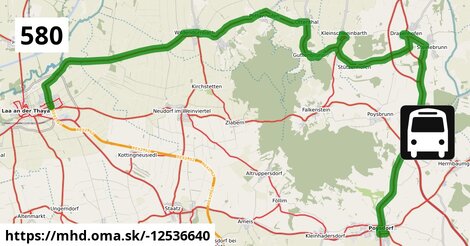
Cesta: OMA » Doprava » iná » bus » Bus 580 Laa/Thaya Bahnhof = > Poysdorf Mittelschule

Bus 580 Laa/Thaya Bahnhof = > Poysdorf Mittelschule

dĺžka 38 km , spravuje Dr. Richard NÖ, číslo trasy 580, názvy: Bus 580 Laa/Thaya Bahnhof => Poysdorf Mittelschule

Zastávky popri linke:

B po ¤, C po ¤, D po 43 m ¤, Wildendürnbach Ortsmitte po 10,4 km ¤, Wildendürnbach Ortsmitte po 10,5 km ¤, Neuruppersdorf Landesstraße po 11,7 km ¤, Neuruppersdorf Landesstraße po 11,7 km ¤, Pottenhofen Ortsmitte po 14,5 km ¤, Pottenhofen Ortsmitte po 14,5 km ¤, Ottenthal bei Mistelbach Volksschule po 17 km ¤, Ottenthal bei Mistelbach Volksschule po 17 km ¤, Ottenthal bei Mistelbach Süd po 18 km ¤, Ottenthal bei Mistelbach Süd po 18 km ¤, Guttenbrunn bei Ottenthal Ortsmitte po 19 km ¤, Guttenbrunn bei Ottenthal Ortsmitte po 19 km ¤, Kleinschweinbarth Landesstraße po 22 km ¤, Kleinschweinbarth Abzweigung Ort po 23 km ¤, Kleinschweinbarth Abzweigung Ort po 23 km ¤, Stützenhofen Obere Hauptstraße po 24 km ¤, Stützenhofen Obere Hauptstraße po 24 km ¤, Drasenhofen Schloss po 27 km ¤, Drasenhofen Schloss po 27 km ¤, Drasenhofen Hauptplatz po 28 km ¤, Drasenhofen Kirchenplatz po 28 km ¤, Drasenhofen Kirchenplatz po 28 km ¤, Steinebrunn Sportplatz po 29 km ¤, Steinebrunn Sportplatz po 29 km ¤, A1 po 38 km ¤, B1 po 38 km ¤, A2 po 38 km ¤, Poysdorf Wiener Straße po 38 km ¤, Poysdorf Mittelschule po 38 km ¤, Poysdorf Mittelschule po 38 km ¤

prestupné linky:

Bus 588: Laa an der Thaya Bahnhof = > Mistelbach Bahnhof (über Ungerndorf Kirche und Frättingsdorf Ortsmitte, nicht über Laa an der Thaya Gymnasium) po 23 m ¤, Bus 588: Laa an der Thaya Bahnhof = > Mistelbach Bahnhof (über Loosdorf bei Staatz Nr. 65) po 23 m ¤, Bus 593: Laa an der Thaya Kirchenplatz = > Hanfthal Ort (über Laa an der Thaya St.-Vitus-Heim) po 23 m ¤, Bus 591: Stronsdorf Hauptplatz = > Laa an der Thaya Stadtplatz (über Ungerndorf Kirche) po 23 m ¤, Bus 591: Laa an der Thaya Bahnhof = > Großharras Gemeindeamt po 23 m ¤, Bus 591: Patzenthal Ortsmitte = > Laa an der Thaya Anton-Bruckner-Straße (über Ungerndorf Kirche) po 23 m ¤, Bus 593: Laa an der Thaya Kirchenplatz = > Laa an der Thaya Stadtplatz po 23 m ¤, Bus 591: Laa an der Thaya Bahnhof = > Stronsdorf Hauptplatz (über Ungerndorf) po 23 m ¤, Bus 593: Laa an der Thaya St.-Vitus-Heim = > Laa an der Thaya Kellerhügel po 23 m ¤, Bus 588: Laa an der Thaya Bahnhof = > Mistelbach Bahnhof (über Laa an der Thaya Volksschule, Gaubitsch Ortsmitte, Loosdorf bei Staatz Nr. 65 und Mistelbach Alleegasse) po 23 m ¤, Bus 590: Mistelbach Bahnhof = > Altmanns bei Mistelbach Ortsmitte = > Asparn/Zaya Schulzentrum = > Laa/Thaya Gymnasium po 23 m ¤, Bus 590: Laa an der Thaya Bahnhof = > Mistelbach Bahnhof (über Zwentendorf an der Zaya Ort) po 23 m ¤, Bus 591: Patzenthal Ortsmitte = > Laa an der Thaya Anton-Bruckner-Straße po 23 m ¤, Bus 591: Laa an der Thaya Bahnhof = > Großharras Gemeindeamt (über Ungerndorf) po 23 m ¤, Bus 591: Laa an der Thaya Bahnhof = > Stronsdorf Hauptplatz (über Laa an der Thaya Volksschule und Kirchenplatz) po 23 m ¤, Bus 813: Laa an der Thaya Bahnhof = > Hollabrunn Bahnhof (über Peigarten bei Haugsdorf Ortsmitte) po 23 m ¤, Bus 593: Laa an der Thaya Kirchenplatz = > Laa an der Thaya Stadtplatz (über Laa an der Thaya Vorgartenstraße) po 23 m ¤, Bus 593: Laa an der Thaya Kirchenplatz = > Hanfthal Ort po 23 m ¤, Bus 591: Laa an der Thaya Bahnhof = > Stronsdorf Hauptplatz po 23 m ¤, Bus 588: Laa an der Thaya Bahnhof = > Mistelbach Bahnhof po 23 m ¤, Bus 588: Mistelbach Bahnhof = > Laa an der Thaya Stadtplatz (über Ernsdorf bei Staatz Kapellenstraße und Laa an der Thaya Volksschule) po 23 m ¤, Bus 590: Laa an der Thaya Bahnhof = > Mistelbach Bahnhof (über Hagendorf Fallbacher Straße und Zwentendorf an der Zaya Ort) po 23 m ¤, Bus 593: Laa an der Thaya Gymnasium = > Laa an der Thaya Kellerhügel po 23 m ¤, Bus 588: Laa an der Thaya Bahnhof = > Mistelbach Bahnhof (über Laa an der Thaya Kirchenplatz und Loosdorf bei Staatz Nr. 65) po 23 m ¤, Bus 582: Poysbrunn Feldstraße = > Laa an der Thaya Gymnasium po 23 m ¤, Bus 591: Laa an der Thaya Bahnhof = > Unterstinkenbrunn Stronsdorfer Straße (über Ungerndorf) po 23 m ¤, Bus 591: Laa an der Thaya Bahnhof = > Stronsdorf Hauptplatz (über Ungerndorf) po 23 m ¤, Bus 588: Mistelbach Bahnhof = > Laa an der Thaya Gymnasium (über Laa an der Thaya Volksschule) po 23 m ¤, Bus 590: Laa an der Thaya Bahnhof = > Mistelbach Bahnhof po 23 m ¤, Bus 588: Laa an der Thaya Bahnhof = > Mistelbach Bahnhof (über Laa an der Thaya Volksschule und Loosdorf bei Staatz Nr. 65) po 23 m ¤, Bus 591: Laa an der Thaya Bahnhof = > Stronsdorf Hauptplatz (über Laa an der Thaya Kirchenplatz) po 23 m ¤, Bus 582: Zlabern Antoniweg = > Laa an der Thaya Gymnasium po 23 m ¤, Bus 588: Laa an der Thaya Bahnhof = > Mistelbach Bahnhof (über Ungerndorf Kirche, nicht über Laa an der Thaya Gymnasium) po 23 m ¤, Bus 813: Laa an der Thaya Bahnhof = > Untermarkersdorf Gasthaus Pulkautaler po 23 m ¤, Bus 591: Zwingendorf Ortsmitte = > Laa an der Thaya Anton-Bruckner-Straße po 23 m ¤, Bus 584: Laa an der Thaya Bahnhof = > Ameis Kirche po 23 m ¤, Bus 593: Laa an der Thaya Vorgartenstraße = > Laa an der Thaya Gymnasium po 23 m ¤, Bus 588: Laa an der Thaya Bahnhof = > Mistelbach Bahnhof (über Ungerndorf Kirche und Frättingsdorf Ortsmitte, nicht über Laa an der Thaya Gymnasium) po 23 m ¤, Bus 588: Laa an der Thaya Bahnhof = > Mistelbach Bahnhof (über Laa an der Thaya Volksschule und Ungerndorf Kirche) po 23 m ¤, Bus 813: Laa an der Thaya Bahnhof = > Hollabrunn Kirchenplatz po 23 m ¤, Bus 813: Laa an der Thaya Bahnhof = > Guntersdorf Bahnhof po 23 m ¤, Bus 581: Laa/Thaya Stadtplatz = > Poysdorf Dreifaltigkeitsplatz po 23 m ¤, Bus 584: Waltersdorf bei Staatz Ortsmitte = > Laa an der Thaya Gymnasium po 23 m ¤, Bus 591: Laa an der Thaya Bahnhof = > Patzenthal Ortsmitte po 23 m ¤, Bus 582: Laa an der Thaya Bahnhof = > Zlabern Antoniweg po 23 m ¤, Bus 582: Laa an der Thaya Bahnhof = > Schrattenberg Kirchenplatz po 34 km ¤, Bus 582: Schrattenberg Kirchenplatz = > Laa an der Thaya Gymnasium po 34 km ¤, Bus 594: Kammersdorf Gemeindeamt = > Poysdorf Dreifaltigkeitsplatz po 38 km ¤, Bus 581: Laa an der Thaya Kirchenplatz = > Poysdorf Dreifaltigkeitsplatz (via Laa Gymnasium) po 38 km ¤, Bus 560: Poysdorf Dreifaltigkeitsplatz = > Bernhardsthal Bahnhof po 38 km ¤

Má spoločné úseky s linkami:

Bus 813: Guntersdorf Bahnhof = > Laa an der Thaya Therme (über Hanfthal Kirche) po 23 m ¤ , Bus 813: Laa an der Thaya Therme = > Guntersdorf Bahnhof po 23 m ¤ , Bus 813: Hollabrunn Kirchenplatz = > Laa an der Thaya Therme po 23 m ¤ , Bus 813: Guntersdorf Bahnhof = > Laa an der Thaya Therme po 23 m ¤ , Bus 813: Hollabrunn Hauptplatz = > Laa an der Thaya Therme po 23 m ¤ , Bus 813: Hollabrunn Hauptplatz = > Laa an der Thaya Therme (über Guntersdorf Bahnhof) po 23 m ¤ , Bus 813: Laa an der Thaya Therme = > Alberndorf im Pulkautal Gemeindeamt po 23 m ¤ , Bus 813: Laa an der Thaya Therme = > Hollabrunn Bahnhof po 23 m ¤ , Bus 104 po 23 m ¤ , Bus 813: Hollabrunn Hauptplatz = > Laa an der Thaya Therme po 23 m ¤ , Bus 813: Laa an der Thaya Therme = > Großkadolz Glockenturm po 23 m ¤ , Bus 580: Pottenhofen Ortsmitte = > Laa/Thaya Gymnasium po 0,92 km ¤ , Bus 580 Wildendürnbach Ortsmitte = > Mistelbach Bahnhof po 14,9 km ¤ , Bus 580: Poysdorf Mittelschule = > Laa/Thaya Stadtplatz po 14,9 km ¤ , Bus 580: Ottenthal Süd = > Staatz Bahnhof po 18 km ¤ , Bus 580 Staatz Bahnhof = > Ottenthal Süd po 18 km ¤ , Bus 580: Poysdorf Dreifaltigkeitsplatz = > Staatz Bahnhof po 21 km ¤ , Bus 580: Poysdorf Dreifaltigkeitsplatz = > Laa/Thaya Stadtplatz (Wochenendfahrten) po 26 km ¤ , Bus 151: Wien Floridsdorf = > Wildendürnbach Ortsmitte po 26 km ¤ , Bus 580 Laa/Thaya Stadtplatz = > Poysdorf Dreifaltigkeitsplatz (Wochenendfahrten) po 27 km ¤ , Bus 580 Laa/Thaya Bahnhof = > Poysdorf Dreifaltigkeitsplatz (via Laa Kirchenplatz, Gymnasium) po 29 km ¤ , Bus 580 Laa/Thaya Stadtplatz = > Poysdorf Dreifaltigkeitsplatz po 29 km ¤ , Flixbus 167: Halle(Saale) ZOB = > Wien Erdberg, Busterminal VIB po 31 km ¤ , Flixbus N1395: Gdynia, dworzec autobusowy = > Wien Erdberg, Busterminal VIB po 31 km ¤ , Flixbus 918: Dworzec autobusowy Warszawa Zachodnia = > Wien, Hbf. (International Busterminal) po 31 km ¤ , Flixbus N903: Praha, ÚAN Florenc = > Zagreb, autobusna stanica po 31 km ¤ , Flixbus N906: Praha, ÚAN Florenc = > Split, autobusna stanica po 31 km ¤ , Flixbus N66: Hamburg ZOB = > Wien, Flughafen Schwechat po 31 km ¤ , Flixbus 895: Brno, autobusové nádraží Hotel Grand = > Zagreb, autobusni kolodvor po 31 km ¤ , Flixbus 366: Praha, ÚAN Florenc = > Wien Erdberg, Busterminal VIB po 31 km ¤ , Flixbus N60: Berlin ZOB = > Zagreb, autobusna stanica po 31 km ¤ , Flixbus 916: Kraków, przystanek autobusowy MDA = > Wien Erdberg, Busterminal VIB po 31 km ¤ , Flixbus 060: Berlin ZOB = > Wien Erdberg, Busterminal VIB po 31 km ¤ , Flixbus 958: Praha, ÚAN Florenc = > Crikvenica, autobusna stanica po 31 km ¤ , Flixbus 919: Wrocław, dworzec autobusowy = > Wien, Flughafen Schwechat po 31 km ¤ , Flixbus N918: Dworzec autobusowy Warszawa Zachodnia = > Wien, Hbf. (International Busterminal) po 31 km ¤ , Flixbus N958: Berlin ZOB = > Rijeka, autobusna stanica po 31 km ¤ , Flixbus 919: Wien, Flughafen Schwechat = > Wrocław, dworzec autobusowy po 33 km ¤ , Flixbus N906: Split, autobusna stanica = > Praha, ÚAN Florenc po 33 km ¤ , Flixbus 958: Crikvenica, autobusna stanica = > Praha, ÚAN Florenc po 33 km ¤ , Flixbus 167: Wien Erdberg, Busterminal VIB = > Halle(Saale) ZOB po 33 km ¤ , Flixbus N60: Zagreb, autobusna stanica = > Berlin ZOB po 33 km ¤ , Flixbus 060: Wien Erdberg, Busterminal VIB = > Berlin ZOB po 33 km ¤ , Flixbus N66: Wien, Flughafen Schwechat = > Hamburg ZOB po 33 km ¤ , Flixbus N918: Wien, Hbf. (International Busterminal) = > Dworzec autobusowy Warszawa Zachodnia po 33 km ¤ , Flixbus 918: Wien, Hbf. (International Busterminal) = > Dworzec autobusowy Warszawa Zachodnia po 33 km ¤ , Flixbus N903: Zagreb, autobusna stanica = > Praha, ÚAN Florenc po 33 km ¤ , Flixbus N1395: Wien Erdberg, Busterminal VIB = > Gdynia, dworzec autobusowy po 33 km ¤ , Flixbus 895: Zagreb, autobusna stanica = > Brno, autobusové nádraží Hotel Grand po 33 km ¤ , Flixbus 916: Wien Erdberg, Busterminal VIB = > Kraków, przystanek autobusowy MDA po 33 km ¤ , Flixbus N958: Rijeka, autobusna stanica = > Berlin ZOB po 33 km ¤ , Flixbus 366: Wien Erdberg, Busterminal VIB = > Praha, ÚAN Florenc po 33 km ¤ , Bus 588 po 37 km ¤ , Bus 580 Wildendürnbach Ortsmitte = > Poysdorf Dreifaltigkeitsplatz po 37 km ¤ , Bus 580: Poysdorf Dreifaltigkeitsplatz = > Laa/Thaya Gymnasium (beschleunigt) po 37 km ¤ , Bus 580: Poysdorf Dreifaltigkeitsplatz = > Laa/Thaya Stadtplatz po 37 km ¤ , Bus 582: Laa an der Thaya Stadtplatz = > Poysdorf Mittelschule po 38 km ¤ , Bus 560: Bernhardsthal Bahnhof = > Poysdorf Mittelschule po 38 km ¤ , Bus 581: Altruppersdorf Ortsmitte = > Poysdorf Mittelschule po 38 km ¤ , Bus 581: Poysdorf Dreifaltigkeitsplatz = > Laa Stadtplatz po 38 km ¤ , Bus 582: Laa an der Thaya Bahnhof = > Poysdorf Dreifaltigkeitsplatz po 38 km ¤ , Bus 582: Falkenstein Dörfl = > Poysdorf Dreifaltigkeitsplatz po 38 km ¤ , Bus 582: Laa an der Thaya Stadtplatz = > Poysdorf Dreifaltigkeitsplatz po 38 km ¤ , Bus 582: Poysdorf Dreifaltigkeitsplatz = > Zlabern Antoniweg po 38 km ¤ , Bus 585: Hausbrunn Friedhofstraße = > Laa an der Thaya Gymnasium po 38 km ¤ , Bus 582: Poysdorf Dreifaltigkeitsplatz = > Staatz Bahnhof po 38 km ¤ , Bus 582: Poysdorf Dreifaltigkeitsplatz = > Laa an der Thaya Stadtplatz po 38 km ¤ , Bus 582: Staatz Bahnhof = > Poysdorf Dreifaltigkeitsplatz po 38 km ¤ , Bus 560: Bernhardsthal Bahnhof = > Mistelbach Bahnhof (via Bernhardsthal Kirche, Poysdorf Mittelschule) po 38 km ¤ , Bus 560: Poysdorf Dreifaltigkeitsplatz = > Mistelbach Bahnhof (via Poysdorf Mittelschule) po 38 km ¤ , Bus 583: Poysdorf Dreifaltigkeitsplatz = > Laa an der Thaya Stadtplatz po 38 km ¤ , Bus 583: Poysdorf Dreifaltigkeitsplatz = > Laa an der Thaya Gymnasium (über Staatz Burgring/Schulen) po 38 km ¤ , Bus 583: Laa an der Thaya Stadtplatz = > Poysdorf Dreifaltigkeitsplatz po 38 km ¤ , Bus 583: Laa an der Thaya Gymnasium = > Poysdorf Dreifaltigkeitsplatz po 38 km ¤ , Bus 569: Poysdorf Dreifaltigkeitsplatz = > Hohenau Bahnhof (via Poysdorf Mittelschule) po 38 km ¤ , Bus 569: Poysdorf Dreifaltigkeitsplatz = > Walterskirchen Großkruter Straße (via Poysdorf Mittelschule) po 38 km ¤ , Bus 151: Wildendürnbach Ortsmitte = > Wien Floridsdorf po 38 km ¤ , Bus 582: Neudorf im Weinviertel Hauptplatz = > Mistelbach Bahnhof po 38 km ¤ , Bus 568: Zistersdorf Kaiserstraße = > Poysdorf Dreifaltigkeitsplatz po 38 km ¤ , Bus 569: Hohenau Bahnhof = > Poysdorf Dreifaltigkeitsplatz (via Wetzelsdorf Feuerwehr, Poysdorf Schulen) po 38 km ¤ , Bus 581: Poysdorf Volksschule = > Laa Stadtplatz po 38 km ¤ , Bus 585: Hausbrunn Friedhofstraße = > Laa an der Thaya Gymnasium po 38 km ¤ , Bus 582: Poysdorf Volksschule = > Laa an der Thaya Stadtplatz po 38 km ¤ , Bus 582: Poysdorf Mittelschule = > Falkenstein Dörfl po 38 km ¤ , Bus 569: Hohenau Bahnhof = > Poysdorf Dreifaltigkeitsplatz po 38 km ¤ , Bus 560: Mistelbach Bahnhof = > Poysdorf Dreifaltigkeitsplatz po 38 km ¤ , Bus 581: Poysdorf Volksschule = > Altruppersdorf Ortsmitte po 38 km ¤ , Bus 569: Poysdorf Dreifaltigkeitsplatz = > Hohenau Bahnhof po 38 km ¤ , Bus 560: Poysdorf Dreifaltigkeitsplatz = > Mistelbach Bahnhof po 38 km ¤ , Bus 569: Großkrut Schulen = > Poysdorf Dreifaltigkeitsplatz po 38 km ¤ , Bus 150: Bernhardsthal Bahnhof = > Wien Floridsdorf po 38 km ¤ , Bus 583: Walterskirchen Großkruter Straße = > Laa an der Thaya Gymnasium po 38 km ¤ , Bus 560: Mistelbach Bahnhof = > Bernhardsthal Bahnhof (via Bernhardsthal Kirche (Volksschule)) po 38 km ¤ , Bus 560: Schrattenberg Kirchenplatz = > Mistelbach Bahnhof po 38 km ¤ , Bus 560: Mistelbach Bahnhof = > Bernhardsthal Bahnhof po 38 km ¤ , Bus 560: Poysdorf Volksschule = > Bernhardsthal Bahnhof po 38 km ¤ , Bus 560: Bernhardsthal Bahnhof = > Mistelbach Bahnhof po 38 km ¤ , Bus 568: Poysdorf Dreifaltigkeitsplatz = > Zistersdorf Kaiserstraße po 38 km ¤ , Bus 560: Bernhardsthal Bahnhof = > Mistelbach Bahnhof (via Mistelbach Alleegasse) po 38 km ¤ , Bus 581: Poysdorf Mittelschule = > Laa Stadtplatz po 38 km ¤ , Bus 582: Poysdorf Mittelschule = > Laa an der Thaya Stadtplatz po 38 km ¤ , Bus 150: Wien Floridsdorf = > Bernhardsthal Bahnhof po 38 km ¤ , Bus 568: Zistersdorf Schloßplatz = > Poysdorf Dreifaltigkeitsplatz po 38 km ¤

Trasa vedie cez obce

Gemeinde Drasenhofen: 10,3 km (26.9 %), Gemeinde Poysdorf: 8,8 km (22.8 %), Gemeinde Wildendürnbach: 6,2 km (16.2 %), Gemeinde Ottenthal: 4,9 km (12.7 %), Gemeinde Neudorf bei Staatz: 4,3 km (11.2 %), Gemeinde Laa an der Thaya: 3,5 km (9.1 %),

Podobné linky 580:

ine: Bus 580: Pottenhofen Ortsmitte = > Laa/Thaya Gymnasium, , ine: Bus 580 Laa/Thaya Bahnhof = > Poysdorf Dreifaltigkeitsplatz (via Laa Kirchenplatz, Gymnasium), , ine: Bus 580: Ottenthal Süd = > Staatz Bahnhof, , ine: Bus 580 Wildendürnbach Ortsmitte = > Mistelbach Bahnhof, , ine: Bus 580: Poysdorf Dreifaltigkeitsplatz = > Laa/Thaya Stadtplatz, , ine: Bus 580 Staatz Bahnhof = > Ottenthal Süd, , ine: Bus 580: Poysdorf Dreifaltigkeitsplatz = > Laa/Thaya Stadtplatz (Wochenendfahrten), , ine: Bus 580 Wildendürnbach Ortsmitte = > Poysdorf Dreifaltigkeitsplatz, , ine: Bus 580: Poysdorf Dreifaltigkeitsplatz = > Staatz Bahnhof, , ine: Bus 580 Laa/Thaya Stadtplatz = > Poysdorf Dreifaltigkeitsplatz (Wochenendfahrten), , ine: Bus 580: Poysdorf Dreifaltigkeitsplatz = > Laa/Thaya Gymnasium (beschleunigt), , ine: Bus 580: Poysdorf Mittelschule = > Laa/Thaya Stadtplatz, , ine: Bus 580 Laa/Thaya Stadtplatz = > Poysdorf Dreifaltigkeitsplatz,
Viac info: aktualizovať mapu, uprav v JOSM (pokročilé), -12536640,
Súradnice: 48°44'21"N, 16°33'43"E
stiahni GPX, najbližšia MHD, route: bus, to: Poysdorf Mittelschule, from: Laa an der Thaya Bahnhof, network: VOR, osm uid: 0, route name: Bus 580 Laa/Thaya Bahnhof => Poysdorf Mittelschule, osm version: 10, osm changeset: 0, osm timestamp: 2024 02 25T21:54:16Z, Q2516485, 2, dlzka: 38418, pocet seg: 1, lon: 16.5621, lat: 48.7394, povodna farba: dr. richard no,
Bus 580 Laa/Thaya Bahnhof = >  Poysdorf Mittelschule

Viac o nás

Podpor projekt OMA:

QR kód na túto stránku mhd.oma.sk -12536640

Spojte sa s nami na facebooku, zdieľajte túto stránku na Facebooku, na Twittri, alebo umiestnite odkaz na svoju stránku.

Ale hlavne doplňte dáta do Openstreetmap, články do wikipédie, ...

Zdroj dát

Mapové údaje pochádzajú z www.OpenStreetMap.org, databáza je prístupná pod licenciou ODbL. OMA logoMapový podklad vytvára a aktualizuje Freemap Slovakia (www.freemap.sk), šíriteľný pod licenciou CC-BY-SA. Fotky sme čerpali z galérie portálu freemap.sk, autori fotiek sú uvedení pri jednotlivých fotkách a sú šíriteľné pod licenciou CC a z wikipédie. Výškový profil trás čerpáme z SRTM. Niečo vám chýba? Pridajte to. Sme radi, že tvoríte slobodnú wiki mapu sveta.