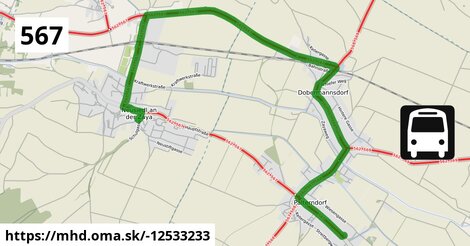
Zastávky na linke
Palterndorf Dobermannsdorfer Straße ¤, Neusiedl an der Zaya Bahnstraße ¤, Dobermannsdorf Viertelstraße ¤, Dobermannsdorf Friedhofsgasse ¤, Palterndorf Feldgasse ¤, Neusiedl an der Zaya Kirche/Schulen ¤, Dobermannsdorf Viertelstraße ¤, Dobermannsdorf Kirche ¤, Dobermannsdorf Volksschule ¤Zastávky popri linke:
Neusiedl an der Zaya Bahnstraße ¤, Palterndorf Dobermannsdorfer Straße ¤, Neusiedl an der Zaya Gemeindeamt ¤, Neusiedl an der Zaya Bahnstraße ¤, Dobermannsdorf Viertelstraße ¤, Neusiedl an der Zaya Gemeindeamt ¤, Dobermannsdorf Friedhofsgasse ¤, Palterndorf Feldgasse ¤, Neusiedl an der Zaya Kirche/Schulen ¤, Dobermannsdorf Viertelstraße ¤, Dobermannsdorf Volksschule ¤, Dobermannsdorf Kirche ¤, Neusiedl an der Zaya Hauptstraße/Schulgasse ¤, Dobermannsdorf Kirche ¤, Dobermannsdorf Volksschule ¤Má spoločné úseky s linkami:
Bus 567: Neusiedl an der Zaya Kirche/Schulen = > Neusiedl an der Zaya Bahnstraße ¤ , Bus 567: Neusiedl an der Zaya Kirche/Schulen = > Dobermannsdorf Viertelstraße ¤ , Bus 567: Mistelbach Bahnhof = > Zistersdorf Hauptstraße ¤ , Bus 567: Mistelbach Bahnhof = > M-City = > Zistersdorf Hauptstraße ¤ , Bus 567: Mistelbach Bahnhof = > Kettlasbrunn = > Zistersdorf Hauptstraße ¤ , Bus 567: Hauskirchen Schulgasse = > Neusiedl an der Zaya Kirche/Schulen ¤ , Bus 567: Hauskirchen Schulgasse = > Neusiedl/Zaya Kirche/Schulen (ohne St. Ulrich Ortsmitte) ¤ , Bus 567: Zistersdorf Schloßplatz = > Wilfersdorf bei Mistelbach Marktplatz ¤ , Bus 567: Zistersdorf Kaiserstraße = > Prinzendorf Sinngasse ¤ , Bus 567: Zistersdorf Kaiserstraße = > Mistelbach Bahnhof ¤ , Bus 567: Zistersdorf Kaiserstraße = > Mistelbach Bahnhof (via St. Ulrich Ortsmitte, ohne M-City) ¤ , Bus 567: Zistersdorf Kaiserstraße = > Mistelbach Bahnhof (via Neusiedl Kirche/Schulen, St. Ulrich Ortsmitte, ohne M-City) ¤ , Bus 567: Zistersdorf Hauptstraße = > Mistelbach Bahnhof ¤ , Bus 567: Neusiedl an der Zaya Kirche/Schulen = > Rannersdorf Abzw Ginzersdorf ¤ , Bus 567: Neusiedl an der Zaya Kirche/Schulen = > Hauskirchen Schulgasse ¤ , Bus 568: Poysdorf Dreifaltigkeitsplatz = > Zistersdorf Kaiserstraße ¤ , Bus 568: Zistersdorf Kaiserstraße = > Poysdorf Dreifaltigkeitsplatz ¤ , Bus 568: Zistersdorf Schloßplatz = > Poysdorf Dreifaltigkeitsplatz ¤ , Bus 569: Poysdorf Dreifaltigkeitsplatz = > Hohenau an der March Bahnhof ¤ , Bus 569: Poysdorf Dreifaltigkeitsplatz = > Poysdorf Mittelschule = > Hohenau an der March Bahnhof ¤ , Bus 569: Hohenau an der March Bahnhof = > Poysdorf Dreifaltigkeitsplatz ¤ , Bus 569: Hohenau an der March Bahnhof = > Wetzelsdorf Feuerwehr = > Poysdorf Schulen = > Poysdorf Dreifaltigkeitsplatz ¤ , Bus 569: Hohenau an der March Bahnhof = > Dobermannsdorf Friedhofsgasse ¤ , Bus 562: Rannersdorf an der Zaya Abzweigung Ginzersdorf = > Hohenau an der March Bahnhof ¤ , Bus 562: Mistelbach Bahnhof = > Hohenau an der March Bahnhof ¤ , Bus 562: Mistelbach Bahnhof = > Mistelbach Hauptplatz = > Hohenau an der March Bahnhof ¤ , Bus 562: Hohenau an der March Bahnhof = > Rannersdorf an der Zaya Abzweigung Ginzersdorf ¤ , Bus 562: Hohenau an der March Bahnhof = > Mistelbach Bahnhof ¤ , Bus 562: Hohenau an der March Bahnhof = > Mistelbach Hauptplatz = > Mistelbach Bahnhof ¤ , Bus 562: Hohenau an der March Bahnhof = > Dobermannsdorf Kirche = > Mistelbach Bahnhof ¤ , Bus 562: Hohenau an der March Bahnhof = > Mistelbach Bahnhof (ohne Halt in Ebersdorf, Bullendorf) ¤ , Bus 562: Hohenau an der March Bahnhof = > Hauskirchen Mühlstraße ¤ , Bus 562: Hauskirchen Mühlstraße = > Hohenau an der March Bahnhof ¤Trasa vedie cez obce
Gemeinde Palterndorf-Dobermannsdorf: 4,2 km (59.6 %), Gemeinde Neusiedl an der Zaya: 2,8 km (40.4 %),

Podobné linky 567:
ine: Bus 567: Hauskirchen Schulgasse = > Neusiedl/Zaya Kirche/Schulen (ohne St. Ulrich Ortsmitte), , ine: Bus 567: Poštorná, Valtická, točna = > Autobusové nádraží, , ine: Bus 567: Autobusové nádraží = > Poštorná, Valtická, točna, , ine: Bus 567: Zistersdorf Kaiserstraße = > Mistelbach Bahnhof, , ine: Bus 567: Neusiedl an der Zaya Kirche/Schulen = > Dobermannsdorf Viertelstraße, , ine: Bus 567: Mistelbach Bahnhof = > Kettlasbrunn = > Zistersdorf Hauptstraße, , ine: Bus 567: Zistersdorf Kaiserstraße = > Prinzendorf Sinngasse, , ine: Bus 567: Gösting Palterndorfer Straße = > Zistersdorf Kaiserstraße, , ine: Bus 567: Zistersdorf Schloßplatz = > Wilfersdorf bei Mistelbach Marktplatz, , ine: Bus 567: Neusiedl an der Zaya Kirche/Schulen = > Neusiedl an der Zaya Bahnstraße, , ine: Bus 567: Zistersdorf Schloßplatz = > Ringelsdorf Obere Hauptstraße, , ine: Bus 567: Neusiedl an der Zaya Kirche/Schulen = > Rannersdorf Abzw Ginzersdorf, , ine: Bus 567: Mistelbach Bahnhof = > Zistersdorf Hauptstraße, , ine: Bus 567: Zistersdorf Kaiserstraße = > Mistelbach Bahnhof (via Neusiedl Kirche/Schulen, St. Ulrich Ortsmitte, ohne M-City), , ine: Bus 567: Zistersdorf Hauptstraße = > Mistelbach Bahnhof, , ine: Bus 567: Mistelbach Bahnhof = > M-City = > Zistersdorf Hauptstraße, , ine: Bus 567: Neusiedl an der Zaya Kirche/Schulen = > Hauskirchen Schulgasse, , ine: Bus 567: Hauskirchen Schulgasse = > Neusiedl an der Zaya Kirche/Schulen, , ine: Bus 567: Zistersdorf Kaiserstraße = > Mistelbach Bahnhof (via St. Ulrich Ortsmitte, ohne M-City),Viac info: aktualizovať mapu, uprav v JOSM (pokročilé), -12533233, stiahni GPX, route: bus, to: Neusiedl an der Zaya Kirche/Schulen, from: Palterndorf Feldgasse, network: VOR, route name: Bus 567: Palterndorf Feldgasse => Neusiedl an der Zaya Kirche/Schulen, osm version: 6, osm changeset: 0, osm timestamp: 2023 10 09T16:50:28Z, Q2516485, 2, dlzka: 7040, pocet seg: 2, lon: 16.8086, lat: 48.6031, povodna farba: gschwindl,