Má spoločné úseky s linkami:
Bus 886: Horn Bahnhof = > Horn Stadtsee = > Drosendorf Schulen ¤ ,
Bus 886: Horn Bahnhof = > Drosendorf Schulen ¤ ,
Bus 886: Horn Hauptplatz = > Drosendorf Schulen (alle Stationen) ¤ ,
Bus 886: Horn Bahnhof = > Dallein Kapelle = > Drosendorf Schulen (nicht über Oberhöflein bei Geras Schloss) ¤ ,
Bus 886: Horn Bahnhof = > Drosendorf Schulen (nicht über Dallein Kapelle, Oberhöflein bei Geras Schloss) ¤ ,
Bus 886: Horn Hauptplatz = > Drosendorf Schulen (nicht über Dallein Kapelle, Oberhöflein bei Geras Schloss und Wolfsbach bei Drosendorf Ort) ¤ ,
Bus 886: Drosendorf Schulen = > Horn Hauptplatz ¤ ,
Bus 886: Drosendorf Schulen = > Wolfsbach bei Drosendorf Ort = > Kottaun Ortsmitte = > Dallein Kapelle = > Horn Bahnhof ¤ ,
Bus 886: Drosendorf Schulen = > Wolfsbach bei Drosendorf Ort = > Horn Bahnhof ¤ ,
Bus 886: Drosendorf Schulen = > Geras Berufsschule = > Horn Bahnhof ¤ ,
Bus 886: Drosendorf Schulen = > Horn Bahnhof ¤ ,
Bus 886: Drosendorf Schulen = > Hötzelsdorf-Geras Bahnhof ¤ ,
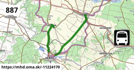
Bus 887: Geras Volksschule = > Hötzelsdorf Pulkaubrücke = > Geras Volksschule ¤ ,
Bus 875: Retz Bahnhof = > Merkersdorf/Hardegg Ortsmitte = > Drosendorf Schulen ¤ ,
Bus 875: Retz Bahnhof = > Drosendorf Schulen ¤ ,
Bus 875: Retz Bahnhof = > Hardegg Burg = > Drosendorf Schulen ¤ ,
Bus 875: Drosendorf Schulen = > Retz Bahnhof ¤ ,
Bus 875: Drosendorf Schulen = > Hardegg Burg = > Retz Bahnhof ¤ Viac info:
aktualizovať mapu,
uprav v JOSM (pokročilé),
-11224170,
stiahni GPX, route: bus, to: Geras Hauptstraße/Stift, via: Hötzelsdorf Pulkaubrücke, from: Geras Volksschule, network: VOR, duration: 01:02, route name: Bus 887: Geras Volksschule => Hötzelsdorf Pulkaubrücke => Geras Hauptstraße/Stift, osm version: 10, osm changeset: 0, osm timestamp: 2025 11 11T15:34:50Z, Q2516485, 2, dlzka: 14630, pocet seg: 2, lon: 15.6910, lat: 48.8146, povodna farba: osterreichische postbus a,
Zdroj dát
Mapové údaje pochádzajú z
www.OpenStreetMap.org, databáza je prístupná pod licenciou
ODbL.

Mapový podklad vytvára a aktualizuje
Freemap Slovakia (www.freemap.sk), šíriteľný pod licenciou CC-BY-SA. Fotky sme čerpali z galérie portálu freemap.sk, autori fotiek sú uvedení pri jednotlivých fotkách a sú šíriteľné pod licenciou CC a z wikipédie. Výškový profil trás čerpáme z
SRTM. Niečo vám chýba?
Pridajte to. Sme radi, že tvoríte slobodnú wiki mapu sveta.